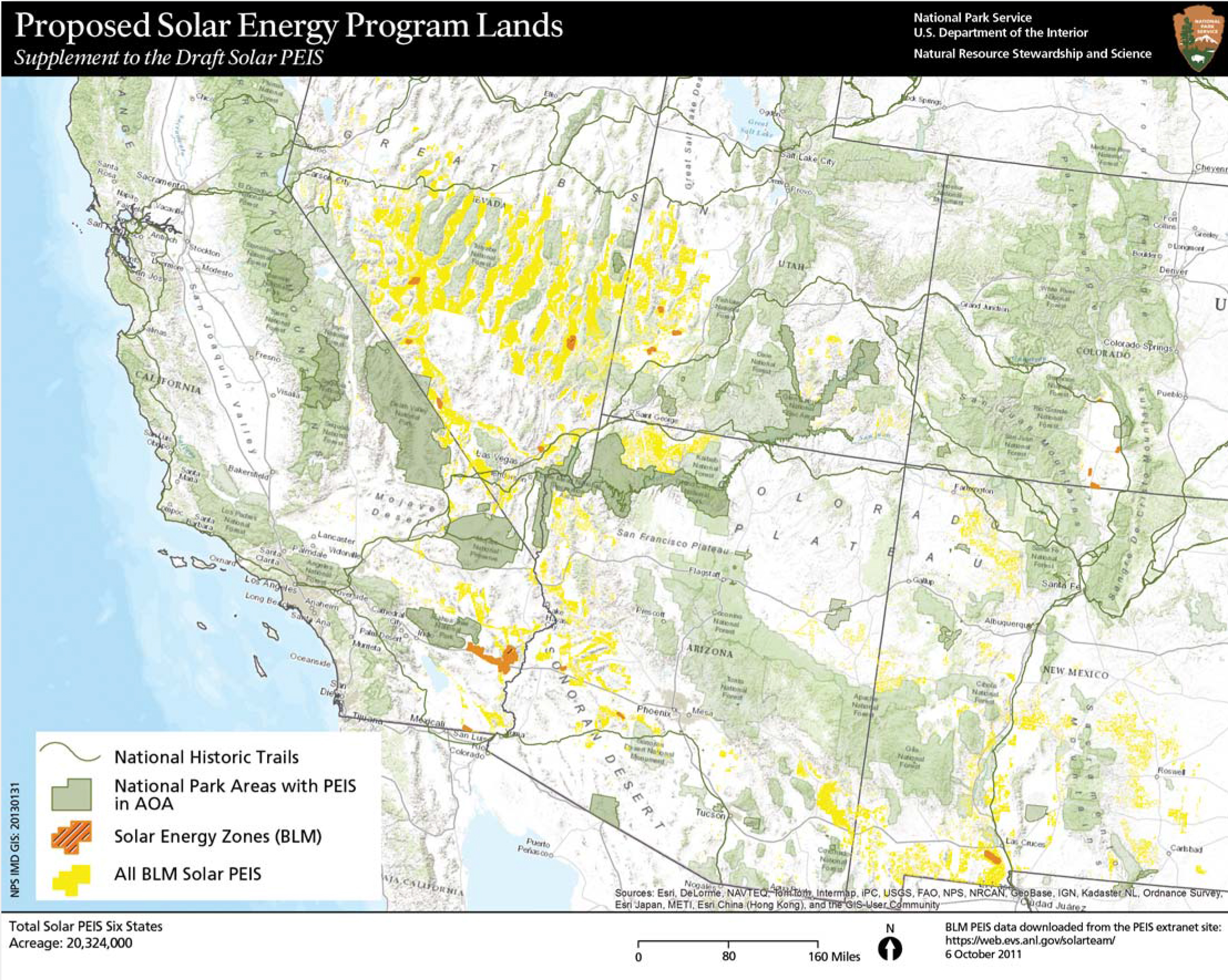
The NPS collaborates with other agencies to identify potential resource conflicts with proposed renewable energy generation. A recent example was a 2011 study with the Bureau of Land Management (BLM) and the Department of Energy (DOE) to review impacts of utility-scale solar energy development in six southwestern states.
Traditionally the NPS assesses the implications of adjacent land use development on a site-specific basis. However, within a park-centered geographic context, this analysis was able to provide broader assessment tools. The Programmatic Environmental Impact Statement for Solar Energy Development in Six Southwestern States (Solar PEIS), evaluates a broad range of potential environmental, social and economic effects on public lands. However, the Solar PEIS is not designed to analyze site-specific impacts, causing the NPS to conduct additional research and analysis to identify solar energy program lands that represent high potential for conflict with natural, visual, and cultural resources administered by the NPS. Given the significant land areas and resource consumption requirements of the broad-scale solar energy development included in the Solar PEIS, the NPS became a cooperating agency to advise the BLM of cross-boundary conflicts with NPS-administered values and resources.
To ensure consistent and systematic response to cumulative impacts from solar energy development across park and regional boundaries, the NPS piloted the geospatial resource conflict analysis (RCA) project. The RCA engaged multiple levels within the NPS and used available geospatial data to assess potential risks of proposed external land use actions included in the Solar PEIS. Utility-scale solar energy projects are often located where conditions are most ideal to capture the sun's energy, including remote areas near national parks and monuments, and other special places administered by the NPS. For this reason, the NPS developed a process to identify specific areas with proposed solar projects that pose a high potential for conflict with NPS-administered natural, visual, and cultural resources.
Analysis and Results
The RCA involves two primary processes: examination of specific resource conditions and determination of potential resource conflicts. The RCA determined that within the 20.3 million-acre footprint of the proposed solar energy program, 5.6 million-acres (28%) of the proposed solar program lands were within the NPS-defined area of analysis. The proximity of solar program lands to these special status places raised concerns about the potential direct and cumulative adverse effects in these areas. This led the NPS to request the BLM to exclude 3.8 million acres of proposed program lands from the Solar PEIS. The BLM response to NPS research and analysis resulted in the exclusion of more than 800,000 acres of program lands that coincided with NPS-identified areas of high potential for conflict. The remaining 3.02 million acres of lands potentially available for solar energy development were identified by the BLM as areas of high potential for resource conflict.
Last updated: September 21, 2016