Skip down the page to view the completed vulnerability assessments
Climate change impacts, including sea level rise, storm surge, and shoreline erosion, present unique hazards for coastal units of the National Park System. Visitor centers, roads, utilities, and other park facilities that support visitor use, along with historic structures, are of particular concern, as they are often fixed in place, provide important services, and represent significant investments.
The National Park Service partnered with the Program for the Study of Developed Shorelines at Western Carolina University to create a Coastal Hazards and Sea-Level Rise Asset Vulnerability Assessment Protocol (2022), which built on the previous 2016 protocol document. This protocol establishes a standard methodology and set of best practices for conducting vulnerability assessments for coastal facilities that considers exposure and sensitivity. Standardizing the methodologies and data utilized in these assessments allows managers to compare the vulnerability of coastal park assets across local, regional, and national levels.
The assessments are currently focused on assets at risk to coastal hazards and sea-level rise within coastal parks. Coastal vulnerability was chosen as a starting point in the development of park-specific vulnerability assessments because of the availability of natural hazards data in digital format and a solid understanding of the trends in the major climate stressors (e.g., sea level).
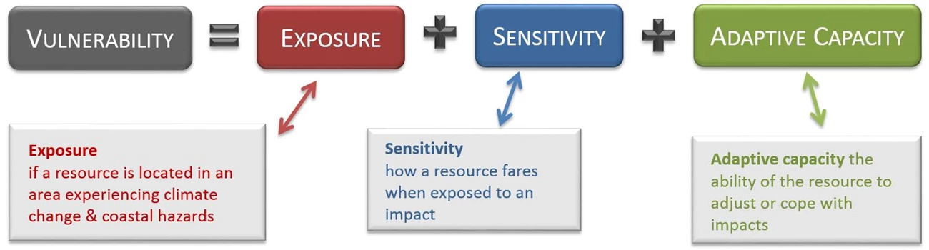
While vulnerability assessments have been successfully developed for natural systems, some aspects are less appropriate for application in the built environment (e.g., buildings, roads, etc.). For example, structures cannot inherently adapt to climate change or other hazards, while natural resources sometimes can. Therefore, the methodology and formula has been modified for conducting vulnerability assessments of assets within national parks.

The adaptive capacity of an asset is evaluated separately and is not included in the vulnerability score. However, the adaptive capacity of an asset is still important to understand to inform appropriate management actions. Identifying and assessing the range of adaptation strategies or options available for key vulnerable assets within a national park is the final and perhaps most important step in the overall analysis. Adaptation actions should be taken that help reduce an asset's exposure and/or sensitivity, which results in reduced vulnerability.
One of the primary goals of this protocol is to standardize methods for evaluating the exposure of NPS assets to coastal hazards and sea-level rise. This includes the standardization of data inputs (this protocol uses widely available, established data) that will allow the application of a consistent methodology among parks to provide comparable outputs. Another goal is to create a more complete and effective set of factors or indicators for assessing the sensitivity of assets to coastal hazards (e.g., is the asset elevated? has there been historical damage? is there protective engineering?). The current focus for this protocol is on structures and transportation assets within the NPS asset database (Facilities Management Software System; FMSS), however, it would be valuable to include other resources such as utilities in future work once data becomes available.
One of the primary goals of this protocol is to standardize methods for evaluating the exposure of NPS assets to coastal hazards and sea-level rise. This includes the standardization of data inputs (this protocol uses widely available, established data) that will allow the application of a consistent methodology among parks to provide comparable outputs. Another goal is to create a more complete and effective set of factors or indicators for assessing the sensitivity of assets to coastal hazards (e.g., is the asset elevated? has there been historical damage? is there protective engineering?). The current focus for this protocol is on structures and transportation assets within the NPS asset database (Facilities Management Software System; FMSS), however, it would be valuable to include other resources such as utilities in future work once data becomes available.
Current coastal facilities vulnerability assessments
- Acadia National Park [2017]
- Assateague Island National Seashore [2023]
- Big Cypress National Preserve [2015]
- Biscayne National Park [2015]
- Boston National Historical Park [2024]
- Boston Harbor Islands National Recreation Area [2025]
- Cabrillo National Monument [2017]
- Canaveral National Seashore [2016]
- Cape Cod National Seashore [2023]
- Cape Lookout National Seashore (pre-Dorian) [2017]
- Cape Lookout National Seashore (post-Dorian) [2023]
- Castillo de San Marcos National Monument and Fort Matanzas National Monument [2022]
- Charles Pinckney National Historic Site [2023]
- Colonial National Historical Park [2017]
- Cumberland Island National Seashore [2022]
- De Soto National Memorial [2022]
- Dry Tortugas National Park [2023]
- Everglades National Park [2022]
- Fire Island National Seashore [2018]
- Fort Frederica National Monument [2022]
- Fort McHenry National Monument And Historic Shrine [2023]
- Fort Monroe National Monument [2023]
- Fort Pulaski National Monument [2023]
- Fort Sumter National Monument [2016]
- George Washington Birthplace National Monument [2023]
- George Washington Memorial Parkway & Theodore Roosevelt Island [2017]
- Golden Gate National Recreation Area, Presidio of San Francisco, and Fort Point National Historic Site [2025]
- Gulf Islands National Seashore [2024 update]
- Gulf Islands National Seashore [2015]
- Independence National Historical Park, Edgar Allen Poe National Historic Site, Thaddeus Kosciuszko National Memorial, and Gloria Dei Church National Historic Site [2023]
- Jean Lafitte National Historical Park & Preserve [2017]
- Manhattan Sites [2023]
- Moores Creek National Battlefield [2022]
- National Mall & Memorial Parks [2017]
- New Bedford Whaling National Historical Park & Roger Williams National Memorial [2019]
- Olympic National Park [2017]
- Outer Banks Group: Cape Hatteras National Seashore, Fort Raleigh National Historic Site, & Wright Brothers National Memorial [2018]
- Padre Island National Seashore [2017]
- Pearl Harbor National Memorial [2025]
- Petersburg National Battlefield [2023]
- Redwood National Park [2025]
- Sagamore Hill National Historic Site [2023]
- Saint Croix Island International Historic Site [2023]
- Salem Maritime National Historic Site [2023]
- San Francisco Maritime National Historical Park [2025]
- San Juan National Historic Site [2023]
- Saugus Iron Works National Historic Site [2023]
- Sitka National Historical Park [2017]
- Sleeping Bear Dunes National Lakeshore [2025]
- St. Croix Parks: Buck Island Reef National Monument, Christiansted National Historic Site, and Salt River Bay National Historical Park & Ecological Preserve [2023]
- Statue of Liberty National Monument [2022]
- Timucuan Ecological and Historic Preserve and Fort Caroline National Memorial [2022]
- Virgin Islands National Park [2023]
- War in the Pacific National Historical Park [2017]
Last updated: August 29, 2025