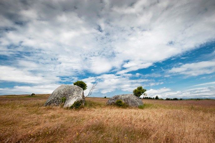
Gary Tarleton The San Juan Islands lay directly in the path of a Pleistocene glaciers that formed and advanced south from the mountains of western British Colombia. The Fraser glaciation, 18,500 to 10,000 years ago, was the last and its effects are readily visible today. The islands were covered by glacial ice up from one to to one half mile thick. It is unclear what the islands looked like before the first glaciation. However, the powerful eroding force of the glaciers definitely smoothed and rounded the landscape of the islands and deepened channels such as Haro and Rosario straits, which run parallel to the direction of glacial advance. The San Juan Islands are composed of more resilient rocks than the rocks found below the waters of the straits. The islands resisted erosion from the glaciers while the channels were carved to a far greater degree. Glaciers scoured and deepened Puget Sound, the Georgia, Haro and Rosario straits. Look for glacial striations, (grooves scratched, etched and scraped in bedrock). Glaciers melt faster in salt water than on land. As the Fraser glacier melted starting about 15,000 years ago, it deposited materials on San Juan Island. Mount Finlayson and the bluffs along South Beach are a glacial moraine comprised of outwash sands and clays. The moraine along South Beach directly below Cattle Point Road varies in height from 30 to 100 feet. Mt Finlayson, which can be reached by hiking trail (see Geologic Formations page), rises 290 feet above sea level. Glacial erratics, rocks and boulders deposited as glaciers melted, can be viewed in the park, especially at American Camp. Some granite erratics on San Juan Island have traveled 200 to 300 miles from the north. After glaciation, sea levels rose to 175 meters higher than they are today as water formerly locked in glacial ice returned to the sea. Sea levels also appeared higher because the land was compressed by the immense weight of the glaciers. As the ice sheets melted, the tremendous weight on the land was removed and the land began to slowly rebound (rise). This is isostatic rebound, which continues today. Isostatic rebound slowed considerably by 6,600 years ago. By 5,000 years ago eustatic (worldwide sea level) increase leveled off to a point where sea levels stabilized to their present level. Although sea levels rose after glaciation the rate of isostatic rebound was greater, thus forming a succession of former beaches that today are viewed as terraces above South Beach. |
Last updated: March 16, 2015