Last updated: June 29, 2021
Place
The Falls of Great Falls
"Ryan dam" by footloosiety is licensed under CC BY 2.0
Quick Facts
Location:
Great Falls, MT
MANAGED BY:
Amenities
3 listed
Parking - Auto, Scenic View/Photo Spot, Trailhead
Lewis and Clark NHT Visitor Centers and Museums
This map shows a range of features associated with the Lewis and Clark National Historic Trail, which commemorates the 1803-1806 Lewis and Clark Expedition. The trail spans a large portion of the North American continent, from the Ohio River in Pittsburgh, Pennsylvania, to the mouth of the Columbia River in Oregon and Washington. The trail is comprised of the historic route of the Lewis and Clark Expedition, an auto tour route, high potential historic sites (shown in black), visitor centers (shown in orange), and pivotal places (shown in green). These features can be selected on the map to reveal additional information. Also shown is a base map displaying state boundaries, cities, rivers, and highways. The map conveys how a significant area of the North American continent was traversed by the Lewis and Clark Expedition and indicates the many places where visitors can learn about their journey and experience the landscape through which they traveled.
In 1804, The Corps of Discovery, a specialized Military Unit, set out under orders from President Thomas Jefferson to explore the Louisiana Purchase. The expedition arrived in present day Montana on April 27, 1805 and on June 13, Captain Meriwether Lewis was witnessing:
“…the grandest sight I ever beheld…whin my ears were saluted with the agreeable sound of a fall of water and advancing a little further; I saw the spray arise above the plain like a collumn of smoke . . . which soon began to make a roaring too tremendous to be mistaken for any cause short of the great falls of the Missouri…”
-Captain Meriwether Lewis
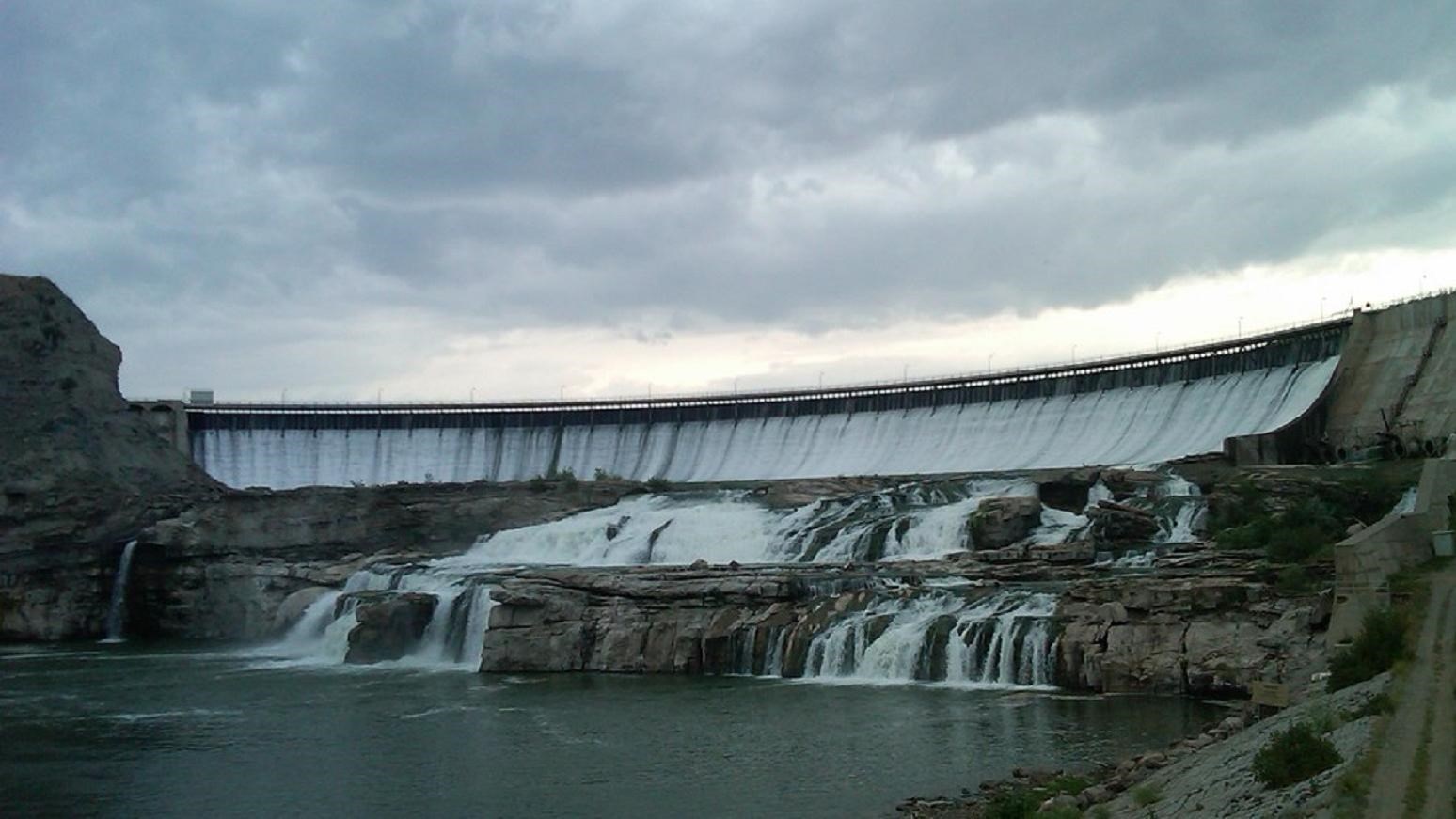
The Great Falls | Ryan Dam
The best view of The Great Falls is done from the highest peak at Ryan Island Park, which is accessed from a suspension bridge across the Missouri River. After traveling a two-lane road that provides views of the expansive high plains and agricultural land, you will arrive at the viewing point of the Great Falls, located at 160 Ryan Dam Road.
There are few hints given along the way of the canyon or the river contained at the end of the road. The roar of the falls is best witnessed in the Spring, just like Captain Lewis experienced. The canyon walls show the arduous task of portaging around the Falls that laid ahead of the Expedition. Although Ryan Dam, constructed in 1915, controls the flow of the water over the falls, the enormity of The Great Falls is still impressive. The dam follows the natural break in the landscape that created the falls and was more than 80 feet high when first seen by Captain Lewis. Today, The Great Falls stand 148 feet due to the dam.
Crooked Falls
Upstream 7 miles from the Great Falls, Crooked Falls flows over an irregular shelf, 19 feet high and 300 yards across. Untouched by a dam, and inaccessible by vehicle, Crooked Falls can be witnessed today just as the Expedition saw it in 1805.
Rainbow Falls | Rainbow Dam
Recorded by Captain Lewis as “Beautifull Cascade” in his journal, Rainbow Falls’ “cascade of about fifty feet perpendicular” was untouched when the dam was constructed in 1910. You can see the magnificent Rainbow Falls at 6401 Giant Springs Road.
Colter Falls
A half mile upstream from Rainbow Falls, the smaller, 6 foot Colter Falls could be found. Set behind Rainbow Dam, these falls are now submerged.
Black Eagle Falls | Black Eagle Dam
Nearest to Great Falls’ city limits, Black Eagle Falls are 2.5 miles above Rainbow Falls. At 26 feet high and 600 yards, these falls were the first to be dammed in 1890. From the top of these falls, the confluence of the Missouri River with the Sun River is visible and from the bottom, Black Eagle Memorial Island Park gives you the closest breathtaking vantage possible. These dramatic falls are located at 5401 River Drive North.
The Dams
Morony Dam
The old town site of Morony still stands and offers a glimpse into where present-day Great Falls almost was. Below Morony Dam is great fishing and a natural spring, Sulphur Springs, accessible by foot or bicycle on River’s Edge Trail.
Cochrane Dam
Cochrane is the newest dam, constructed in 1958, between The Great Falls and Crooked Falls and is only seen along the River’s Edge Trail while walking or biking.