Last updated: June 7, 2019
Place
Tavern Cave
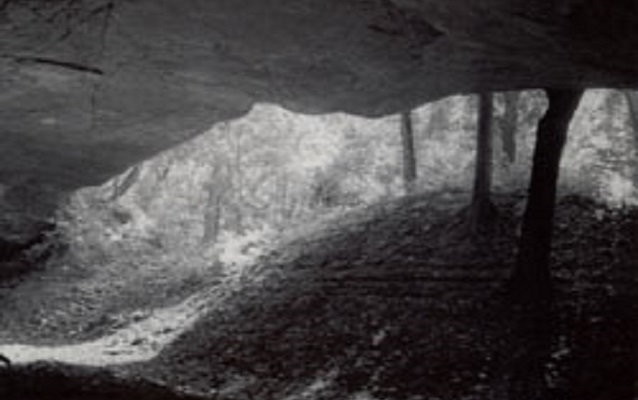
Photo by H. Roger Grant/Missouri State Park Board
Quick Facts
Location:
2 mi northeast of St. Albans, MO
Designation:
National Register of Historic Places
OPEN TO PUBLIC:
No
On May 23, 1804, two days after leaving St. Charles, the Lewis and Clark Expedition visited Tavern Cave. It's located at the south bank of the Missouri River at the base of a huge sandstone bluff called Tavern Rock. This landmark, well known to the Indians, French and Spanish trappers and traders, was first described by Lewis and Clark as:
“. . . a large cave called by the French the Tavern - about 120 feet wide 40 feet deep & 20 feet high. Many different immages are painted on the rock. At this place the Ind. & French pay omage. Many names are wrote on the rock. Stoped about one mile above for Capt. Lewis who had assended the clifts which is at the said cave 300 fee[t] high, hanging over the waters..Capt. Lewis near falling from the pinecles of rocks 300 feet. He caught at 20 foot. Saved himself by the assistance of his knife . . .”
On September 21, 1806, the explorers once again passed Tavern Cave on their journey home. Today, Tavern Cave sits approximately 250 feet from the edge of the Missouri River and is 20 feet smaller in width than when Lewis and Clark visited here.
Tavern Cave is a High Potential Historic Site on the Lewis and Clark National Historic Trail.
On May 23, 1804, two days after leaving St. Charles, the expedition visited Tavern Cave, located on the south bank of the Missouri River at the base of a huge sandstone bluff called Tavern Rock. This landmark, well known to indigenous tribes and European trappers and traders, was first described by Clark as “…an endented part of a Rock which juted over the water, Called by the french the tavern which is a Cave 40 yds. long with the river 4 feet Deep & about 20 feet high, this is a place the India[ns] & french Pay omage to, many names are wrote up on the rock Mine among others…” Clark also wrote that “Capt Lewis' assended the hill which has peninsulis projecting in raged points to the river, and was near falling from a Peninsulia […]Saved himself by the assistance of his Knife…” On September 21, 1806, the expedition once again passed Tavern Cave on their journey home.
Tavern Cave is one of the best known surviving landmarks of early Missouri River exploration, and has likely provided shelter to humans for thousands of years. During the 18th and 19th centuries, it served as a stopover for both Native American bands and European-American travelers. Tavern Cave is noted on the Evans- Mackay map of circa 1795-1797, which Thomas Jefferson provided to Lewis and Clark. Today, the Missouri River channel has shifted to about 250 feet west of the cave mouth. Much of Tavern Rock, the bluff above the cave, was blasted away during the construction of a railroad. As a result, a large mound of debris now largely obscures the mouth of Tavern Cave.