Last updated: October 10, 2024
Place
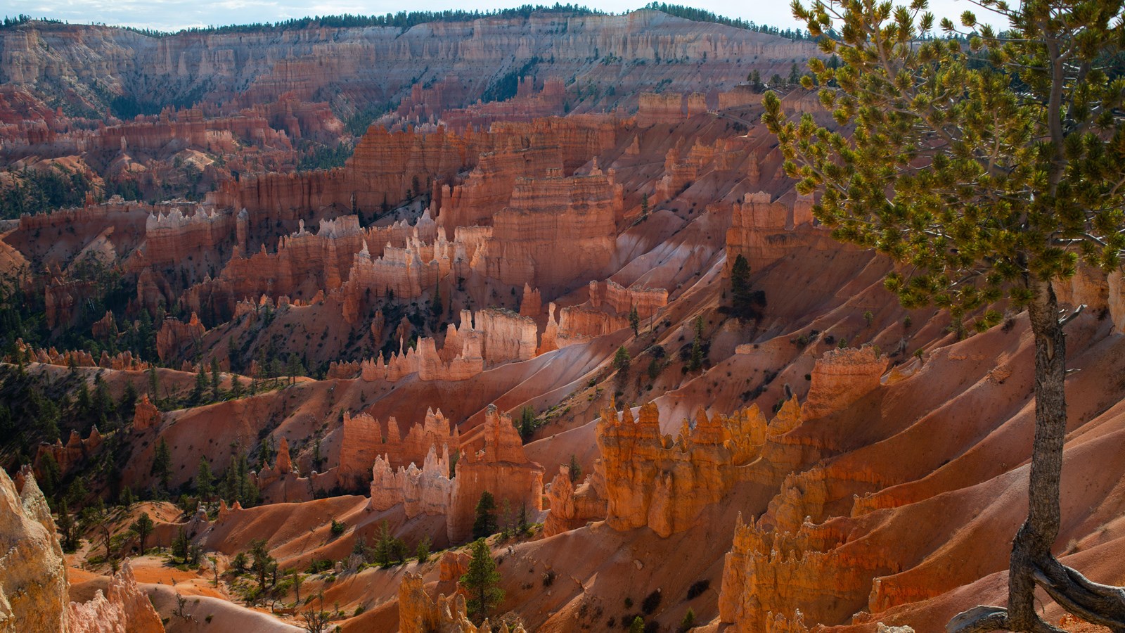
Sunrise Point
NPS Photo / Peter Densmore
Quick Facts
Location:
Northernmost view of the Bryce Amphitheater, north of Sunset Point
Significance:
One of the park's first viewpoints
Designation:
Fully Accessible: Test
Sunrise Point is the northernmost of the four major viewpoints that overlook the iconic Bryce Amphitheater. Though this point along with Sunset Point was named to entice early Lodge visitors to easily accessible points along the rim at both times of day, this view is equally spectacular at daybreak and day's end. At an elevation of 8,100 feet (2,469 m), Sunrise Point is just slightly higher than the Rim Trail and the ponderosa forest to the west. This provides one with a 360 degree view, making it a great choice for stargazers, and those hoping to see the sun's final light along the western horizon. The view of the rock formations (hoodoos) within the Bryce Amphitheater is exceptional as well. Here one can clearly see the full process of hoodoo formation as the plateau rim erodes back exposing walls or fins of layered rock, which are then broken by frost-wedging with windows (arches) that expand to eventually form the isolated columns of stone known as hoodoos. Further east, the eye traces to see these hoodoos' final state: colorful badlands of sediment spotted with vegetation, including bristlecone pines. The popular Queen's Garden trail provides an unforgettable journey down a ridgeline that provides views of every stage of this process.
Trails
The 5.5 mile (8.9 km) Rim Trail connects this view to Sunrise and Fairyland Points further north and Inspiration and Bryce Points further south. The most popular section is the 0.5 mile (0.8 km) section between here and Sunrise Point. This section is paved (and therefore permits leashed pets) and has minimal elevation changes. The Queen's Garden Trail also descends from this viewpoint area.
Landscape Features
To the Northeast
See the flat-topped feature of Boat Mesa and the angled slope of Sinking Ship set against the stark Pink Cliffs of the Table Cliff Plateau 17.5 miles (28 km) distant. The roughly 30 degree slope of Sinking Ship is evidence of the Paunsaugunt fault line, which travels north-south roughly along the eastern edge of the park. This fault, along with large fields of volcanic rock north of the park, were created as part of the tectonic events that elevated the Colorado Plateau region to its present day elevations and later produced the Basin and Range region to the west. The fault is a normal fault, which means that it was formed by extension--the ground you're standing upon moving down and away from the opposite side of the valley. This movement accounts for the 2,000 foot (610 m) difference in elevation between the Bryce Amphitheater and the Table Cliff plateau, despite these being formed of the same rock layer. Sinking Ship is slightly caught upon this fault, explaining its tilted appearance. Though once a site of intense movement, little activity has been recorded along the fault in the last 9 million years.
To the East
The large crown-shaped feature in the middle of the Bryce Amphitheater is known as Bristlecone Point. If you have some binoculars, you may be able to see their scraggly forms upon the white layers of the Claron formation capping Bristlecone Point. You can see that between here and Bristlecone Point is a series of colorful badlands that continue to the north, but steeply drop off into more forested areas to the south. One can see this as a north/south dividing line within the Bryce Amphitheater, where areas south have been eroded more deeply and undercut cliffs to the south (a trend that increases the further south in the park you travel), while erosion has been gentler and less dramatic further north. Beyond Bristlecone Point is the broad Paria Valley, which has been formed over the last 6 million years by the Paria River. The Paria River ultimately joins the Colorado River not too far from Navajo Mountain, visible on the southeastern horizon.
To the South
To the south, one can also see Sunset, Inspiration, and Bryce Points along the forested rim of the Paunsagunt Plateau. If you have an especially good eye (and know what you're looking for) you can spot Thor's Hammer along the Two Bridges side of the Navajo Loop below Sunset Point.
Nature
The Limber Pine at Sunrise Point (known as "Stilts"), roots exposed by erosion of the rim, serves as a reminder of the resilience and ability of life to adapt to adverse conditions, and also of the rapidity with which the scene before us is disappearing. Geologists have calculated that the rim of the canyon is eroding at a rate of one to four feet every century and that in approximately three million years, Bryce Canyon will be gone forever. The hoodoos of Bryce Canyon's main amphitheater appear as a snapshot in the rapid process of erosion on the Paunsaugunt Plateau. This rapidly eroding land creates a harsh environment for any living thing, and like this limber pine, all creatures which live here, from people to animals to plants, must adapt to the conditions in order to survive.