Last updated: July 27, 2022
Place
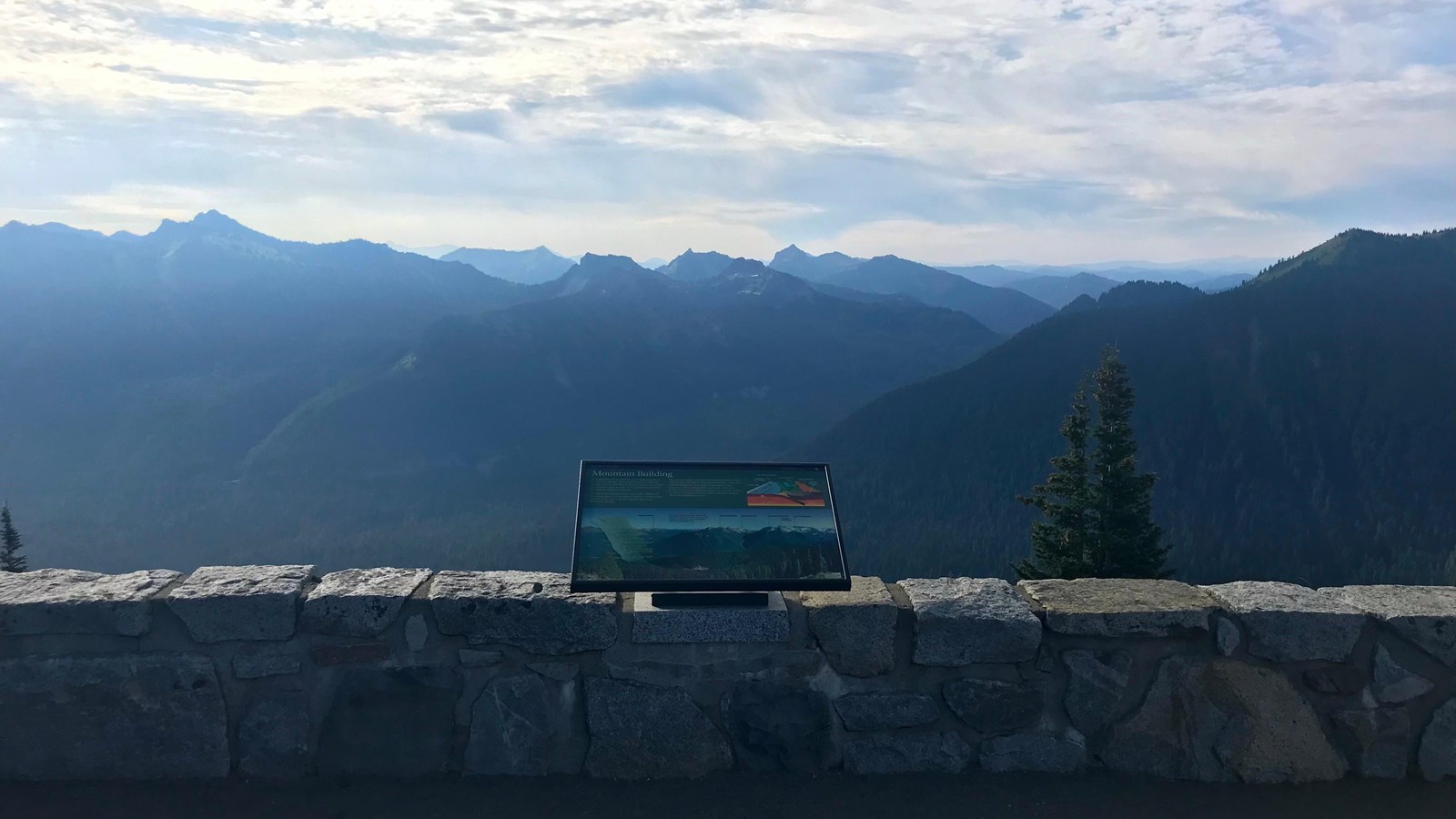
Sunrise Point South Exhibit Panel
NPS Photo
Quick Facts
Location:
South side of Sunrise Point, which is located 7.4 miles up the Sunrise Road from the White River Campground wye.
Amenities
3 listed
Historical/Interpretive Information/Exhibits, Parking - Auto, Scenic View/Photo Spot
Title: Mountain Building
Main Text
At 14,410 feet, Mount Rainier is the highest peak in the Cascade Range. Along with Mount St. Helens, Mount Adams, and Mount Baker, it is part of a chain of volcanoes that extends from northern California to southern British Columbia. The Cascade volcanoes arise from the collision of enormous sheets of the planet's surface. These large slabs of rock, called tectonic plates, float atop the Earth's mantle. Here in the Pacific Northwest, the Juan de Fuca Plate plunges beneath the North American Plate, a process called subduction. The high temperatures and pressures of the subduction zone melt solid rock. Some of the newly-formed magma rises to the surface to erupt, forming volcanoes such as Mount Rainier above the subduction zone.
Secondary Text
On a clear day, you can see three other Cascade volcanoes: Mount Adams to the south; Glacier Peak and Mount Baker behind you looking north.
Exhibit Panel Description
The main text stretches across the top third of the exhibit panel on the left side against a green background. To the right of the main text is a small illustration of a subduction zone. In the illustration, a cross-section of the earth shows how the Juan De Fuca Plate is pushed under the North American Plate, where it melts into magma under the earth's surface. The magma bubbles up a magma conduit under the Cascade Range and Mount Rainier. Stretching across the bottom two-thirds of the panel is a photo of the Cascade Range as viewed from the panel's location at Sunrise Point. Numerous mountain peaks are visible above deep, forested valleys. From left to right the peaks are labeled: Seymour Peak, Governors Ridge, Mount Adams, Tamanos Mountain, and Cowlitz Chimneys. Glaciers below the Cowlitz Chimneys are labeled the Sarvant Glaciers. The secondary text is in the center of the photo. A semi-transparent map of the west coast of North America overlays the left side of the photo with triangles representing the locations of volcanoes along the Cascade Range. From north (top) to south (bottom), the volcanic peaks are labeled: Mount Baker, Glacier Peak, Mount Rainier, Mount Adams, Mount St. Helens, Mount Hood, Mount Jefferson, Three Sisters, Newberry Caldera, Crater Lake, Mount McLoughlin, Medicine Lake, Mount Shasta, and Lassen Peak. A small box in the lower right corner of the panel reads "User Fee Project. Your Fee Dollars at Work. Entrance fees were used to produce this exhibit".
Visit This Exhibit Panel
This is one of three exhibit panels located at Sunrise Point along the Sunrise Road. The panel looks south over the Cascade Range and the White River Valley. Sunrise Road is open to vehicles during the summer, typically from early July to September.