Last updated: December 9, 2025
Place
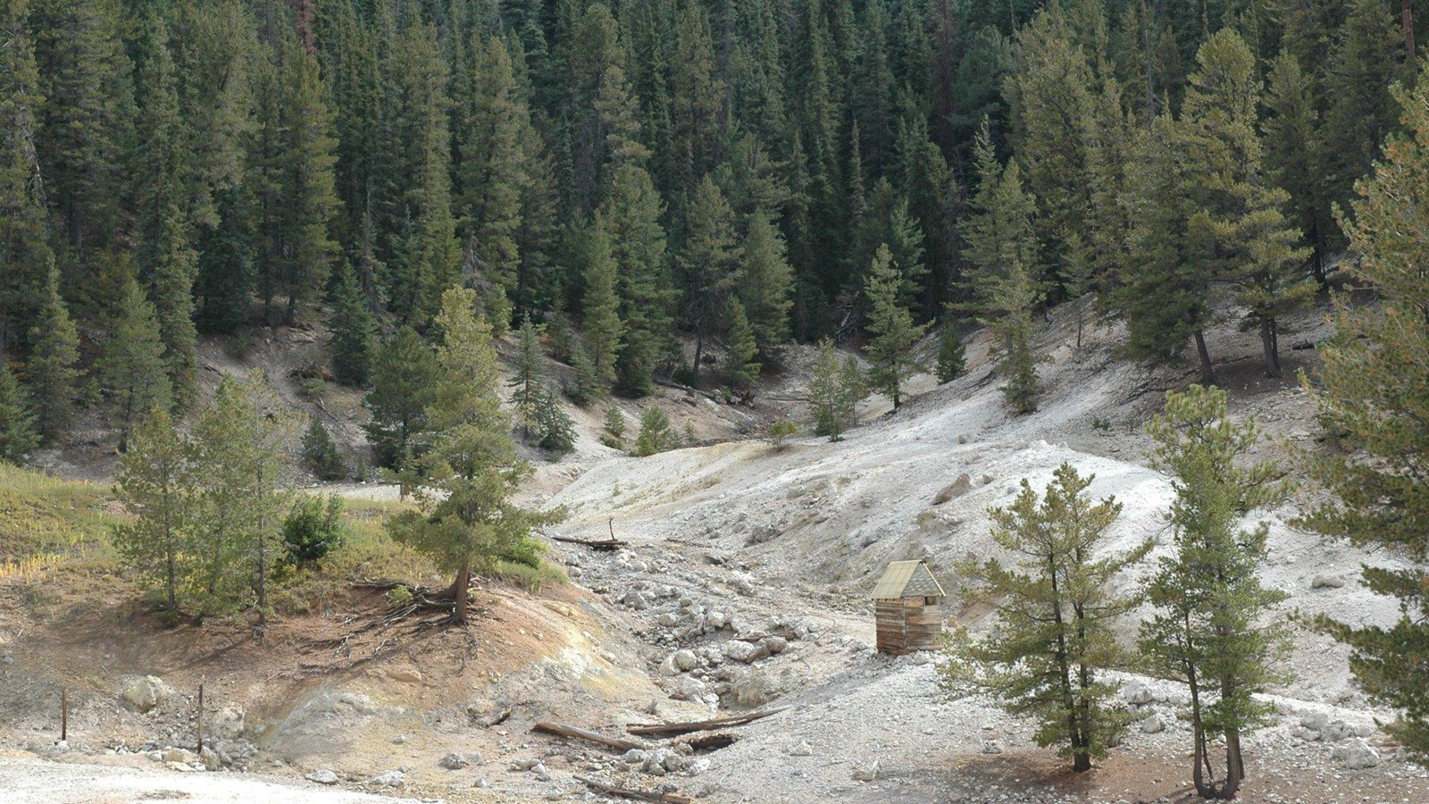
Stop 3: Sulphur Springs
NPS/Dan Kish
Quick Facts
Amenities
1 listed
Scenic View/Photo Spot
You have arrived at Sulphur Springs. You likely smell a “rotten egg” smell. This is hydrogen sulfide gas escaping from the springs, mudpots, and fumaroles. Valles Caldera is a dormant, but not extinct, volcano, and hydrogen sulfide and carbon dioxide gasses escape from the partly crystallized magma that lies about 4 to 6 miles below the surface. You will see bubbles of gas escaping from the water or mud as you walk around the area.
The hydrogen sulfide and carbon dioxide gases react with groundwater and oxygen to form carbonic acid and sulfuric acid. That is how the water becomes acidic. The geologic definition of a spring is where groundwater flows onto the Earth’s surface. Here, rainwater and melted snow sink into the ground, encounter hot rock, are heated and then return to the surface as warm and hot springs. Some of the water at Sulphur Springs does not travel deep enough to warm but still encounters the gas and becomes acidic. The rising water and gas come to the surface where there are pathways between and inside rocks. Here, at Sulphur Springs, the water and gas are coming up along faults, where rocks have been broken apart by tectonic stresses in the earth.
Rocks in the area are altered to clay minerals by the acidic nature of the water. This is what creates the bleached, washed-out colors and the thick muddy material that you will see bubbling in the special, water restricted springs, called mudpots.
This area has been used for many things over the years. Sulphur Springs is located along an ancestral route where indigenous people have long procured medicinal plants and undertaken pilgrimage runs into the healing Jemez Mountains. Maríano Otero and family operated a sulfur mine here from 1900 to 1904. A total of about 200,000 pounds of sulfur was extracted during this time.
Later there was a spa and hotel here. The hotel was built in the early 1900s by the Otero family and burned sometime in the 1970s. Historical photos show that it was likely located partway up the hill to your right.
Other buildings and weathered lumber scattered around are what remains of the spa and of a later settlement of people that occupied the area into the early 2000s.
Sulphur Springs has also been studied for geothermal energy potential. In preparation for the geothermal power plant, several test wells were drilled, an Environmental Impact Statement was written, and permitting was pursued to develop the area. Environmental groups and the Pueblos were against the development because the power plant would have adverse effects on the water supply. Additionally, the Pueblos objected to the adverse impact it would have on their religious sites. Lawsuits and counter lawsuits dragged on for years, and eventually the developers figured out that the area wasn’t suitable for a geothermal site and the whole thing was dropped. It isn’t a good candidate for geothermal energy production because although the water is very hot, especially a few thousand feet down, and would easily flash to steam when brought to the surface, there is not enough of it to maintain the flow needed to drive a turbine for electricity generation. The wells that were drilled as part of the study for geothermal energy potential provided a lot of information about the structure of the rocks in Valles Caldera as well as information about groundwater flow. Additional wells were drilled into the area later as part of the Continental Scientific Drilling Program. The goal of the program was to understand the geologic structure and history better and it was successful.
The National Park Service acquired the Sulphur Springs area in 2020. Many individuals, charitable organizations, and foundations contributed and facilitated the purchase. If you are interested in more information about the acquisition, check out this news release.
To the right (south) of the path where the creek crosses under the road is a cold, bubbling spring commonly called Laxative Spring. It may appear milky blue. There are a few other cold springs nearby, mostly located north (left) of the road. Even though they are cold, with temperatures around 59 degrees F in late May, they are acidic with pH values of around 3. For comparison, drinking water has a pH around 7. They are likely cold because the water source does not go deep in the earth and warm. Future investigations may tell us more about these interesting features.
Ha llegado a Sulphur Springs. Probablemente perciba un olor a «huevo podrido». Se trata de gas sulfhídrico que se escapa de los manantiales, los pozos de lodo y las fumarolas. Valles Caldera es un volcán inactivo, pero no extinto, y los gases de sulfuro de hidrógeno y dióxido de carbono se escapan del magma parcialmente cristalizado que se encuentra a unos 6 a 10 km por debajo de la superficie. Verá burbujas de gas escapándose del agua o del lodo mientras camina por la zona.
Los gases de sulfuro de hidrógeno y dióxido de carbono reaccionan con el agua subterránea y el oxígeno para formar ácido carbónico y ácido sulfúrico. Así es como el agua se vuelve ácida. La definición geológica de un manantial es el lugar donde el agua subterránea fluye hacia la superficie de la Tierra. Aquí, el agua de lluvia y la nieve derretida se hunden en el suelo, encuentran rocas calientes, se calientan y luego regresan a la superficie en forma de manantiales cálidos y termales. Parte del agua de Sulphur Springs no llega a calentarse al descender a suficiente profundidad, pero sí entra en contacto con el gas y se vuelve ácida. El agua y el gas ascendentes llegan a la superficie, donde hay pasajes entre las rocas y dentro de ellas. Aquí, en Sulphur Springs, el agua y el gas ascienden a lo largo de fallas, donde las rocas se han fracturado por las tensiones tectónicas de la Tierra.
Esta zona se ha utilizado para muchos fines a lo largo de los años. Sulphur Springs se encuentra en una ruta ancestral por la que los indígenas han obtenido plantas medicinales y han realizado peregrinaciones a las montañas curativas de Jemez. Maríano Otero y su familia explotaron una mina de azufre aquí entre 1900 y 1904. Durante ese tiempo se extrajeron un total de unas 200 000 libras de azufre.
Más tarde, se construyó aquí un balneario y un hotel. El hotel fue construido a principios del siglo XX por la familia Otero y se incendió en algún momento de la década de 1970. Las fotos históricas muestran que probablemente estaba situado a mitad de la colina, a la derecha.
Otros edificios y madera desgastada esparcida por los alrededores son lo que queda del balneario y de un asentamiento posterior de personas que ocuparon la zona hasta principios de la década de 2000.
Sulphur Springs también ha sido objeto de estudios para determinar su potencial geotérmico. Como preparación para la central geotérmica, se perforaron varios pozos de prueba, se redactó una declaración de impacto ambiental y se solicitaron los permisos para desarrollar la zona. Los grupos ecologistas y los pueblos indígenas se opusieron al proyecto porque la central eléctrica tendría efectos adversos en el suministro de agua. Además, los pueblos indígenas se opusieron al impacto negativo que tendría en sus lugares religiosos. Las demandas y contrademandas se prolongaron durante años y, finalmente, los promotores se dieron cuenta de que la zona no era adecuada para una central geotérmica y se abandonó todo el proyecto. No es un buen candidato para la producción de energía geotérmica porque, aunque el agua es muy caliente, especialmente a unos mil metros de profundidad, y se convertiría fácilmente en vapor al llegar a la superficie, no hay suficiente para mantener el caudal necesario para impulsar una turbina para la generación de electricidad.
Los pozos que se perforaron como parte del estudio sobre el potencial geotérmico proporcionaron mucha información sobre la estructura de las rocas en Valles Caldera, así como sobre el flujo de las aguas subterráneas. Posteriormente se perforaron pozos adicionales en la zona como parte del Programa Continental de Perforación Científica. El objetivo del programa era comprender mejor la estructura y la historia geológicas, y fue un éxito.
El Servicio de Parques Nacionales adquirió la zona de Sulphur Springs en 2020. Muchas personas, organizaciones benéficas y fundaciones contribuyeron y facilitaron la compra. Si te interesa obtener más información sobre la adquisición, consulta este comunicado de prensa.
A la derecha (sur) del camino, donde el arroyo cruza por debajo de la carretera, hay un manantial frío y burbujeante comúnmente llamado Laxative Spring. Puede parecer de color azul lechoso. Hay otros manantiales fríos en las cercanías, la mayoría situados al norte (izquierda) de la carretera. Aunque son fríos, con temperaturas en torno a los 15 °C a finales de mayo, son ácidos, con valores de pH en torno a 3. A modo de comparación, el agua potable tiene un pH en torno a 7. Probablemente sean fríos porque la fuente de agua no se adentra en la tierra y se calienta. Las investigaciones futuras nos darán más información sobre estas interesantes características.