Last updated: November 28, 2023
Place
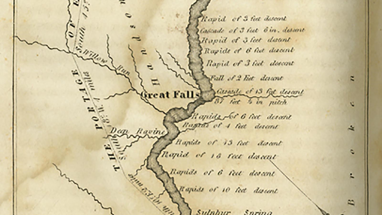
Portage Route
University of Montana Library
Quick Facts
Location:
4201 Giant Springs Rd, Great Falls, MT 59405
Significance:
The Lewis and Clark Expedition portaged for eighteen miles around these waterfalls on the Upper Missouri River.
Designation:
Lewis and Clark National Historic Trail, National Historic Landmark, U.S. Forest Service
MANAGED BY:
Amenities
14 listed
Elevator, Gifts/Souvenirs/Books, Historical/Interpretive Information/Exhibits, Information, Information - Ranger/Staff Member Present, Parking - Auto, Parking - Bus/RV, Picnic Table, Restroom, Restroom - Accessible, Scenic View/Photo Spot, Trailhead, Trash/Litter Receptacles, Wheelchair Accessible
Mandan people had told Meriwether Lewis and William Clark about the Great Falls on the Missouri River. They explained that these falls were on the way to the Shoshone people.
When the Lewis and Clark Expedition arrived here, they knew they were on the right path—a path laid out for them by the Indigenous people who had long known this spot.
Blackfeet, Shoshone, and other Indigenous people often visited these falls, but no one was there when Lewis and Clark’s party needed to portage around these (in contrast to falls along the Columbia River, where Lewis and Clark paid locals to help them get their boats around).
What is a portage? The term was common in 1805, but we do not use it very often today. A portage is when you take your boat out of the water and carry it overland for period, usually to get around dangerous waterfalls, shallow water, or pass between two separate bodies of water.
This portage was exceptionally difficult because it involved an eighteen-mile overland trek that required going up and down “several deep ravines.”253 Men in the expedition double-soled their moccasins to protect their feet from prickly pear cactus needles and sharp points of earth caused by bison trampling on it after heavy rains.
One day during the portage, a thunderstorm blew through with huge hail. Sacagawea lost her baby’s cradle, and she and her husband almost drowned. York was stranded on the plains during the torrent, and several other men, who wore no hats and few clothes, were left bruised and bloodied by the massive hailstones.
The weather continued to be extreme, and unrelenting heat exhausted them. Everyone complained about the mosquitos. On easier days, they caught fish, hunted bison, and repaired their guns.
They built wheeled carts to tow their canoes and luggage over those steep ravines and unforgiving ground. They left behind some boats, and Clark led some men to carve new dugout canoes above the falls. They dug another cache to lighten their load. At one point, the wind blew so hard at their back that they hoisted the sail of the canoe. “this is Saleing on dry land in everry Since of the word,” wrote John Ordway.
On July 15, over a month after they arrived at this stretch of river, they loaded up the canoes and set off again. This was the hardest portage that they experienced. And perhaps related, it was one of the only portages where they received no help from Indigenous people.
About this article: This article is part of a series called “Pivotal Places: Stories from the Lewis and Clark National Historic Trail.”
Lewis and Clark NHT Visitor Centers and Museums
This map shows a range of features associated with the Lewis and Clark National Historic Trail, which commemorates the 1803-1806 Lewis and Clark Expedition. The trail spans a large portion of the North American continent, from the Ohio River in Pittsburgh, Pennsylvania, to the mouth of the Columbia River in Oregon and Washington. The trail is comprised of the historic route of the Lewis and Clark Expedition, an auto tour route, high potential historic sites (shown in black), visitor centers (shown in orange), and pivotal places (shown in green). These features can be selected on the map to reveal additional information. Also shown is a base map displaying state boundaries, cities, rivers, and highways. The map conveys how a significant area of the North American continent was traversed by the Lewis and Clark Expedition and indicates the many places where visitors can learn about their journey and experience the landscape through which they traveled.