Last updated: April 23, 2026
Place
Missouri: Meramec River U.S. 66 Bridge
NPS Photo
Quick Facts
Location:
Old U.S. Hwy 66 Eureka, MO 63025
Significance:
Historic bridge along Route 66
Designation:
National Register of Historic Places
MANAGED BY:
Amenities
1 listed
Historical/Interpretive Information/Exhibits
After its designation in 1926, the course Route 66 took from Illinois to California did not remain static. As practical and political concerns arose, authorities rerouted it to meet them. Meramec River U.S. 66 Bridge resulted from this rerouting. The bridge and the road it supported helped to transform the surrounding area from a wealthy retreat center to a working-class town. More recently, the bridge has become a centerpiece of a state park devoted to Route 66.
Local government mostly funded and maintained highways and bridges before the late 19th century. Boats and trains were the preferred means of transportation before that time, and roads were expensive. In the late-19th and early-20th centuries, bicycle and automobile enthusiasts began establishing good roads associations to lobby for highway infrastructure, and the States and Federal government responded with funding for transportation.
A combination of state and federal actions developed Missouri’s 20th-century road system. In response to good roads pressure, Missouri established a state highway system in 1909 and an inter-county network road system in 1913. In 1916, the United States passed the Federal Highways Act to begin funding interstate roads. Missouri responded in 1917 by creating a state road fund, State Highway Board, and State Highway Engineer to supplement federal funding. The most far-reaching state legislation occurred in 1921, when the Centennial Road Law made the state solely responsible for road building. Missouri established a Bureau of Bridges the same year to deal solely with the issue of crossings.
Bridge building increased dramatically in Missouri during the 1920s. In 1918, the state funded a mere 35 new bridges. By 1931, the Bureau of Bridges had prepared designs for 2,465 additional bridges. When the United States designated Route 66 as a federal highway in 1926, Missouri’s existing infrastructure enabled its routing across the state.
Route 66 initially bypassed the lower Meramec River, which late 19th-century hotel and railroad operators had made a destination for well-off area residents. The grandest resort was the Meramec Highlands, established in 1895 ten miles upriver from the eventual bridge site. The 1904 World's Fair in St. Louis introduced a new audience to the area as well. In 1925, a working-class resort called Times Beach opened there.
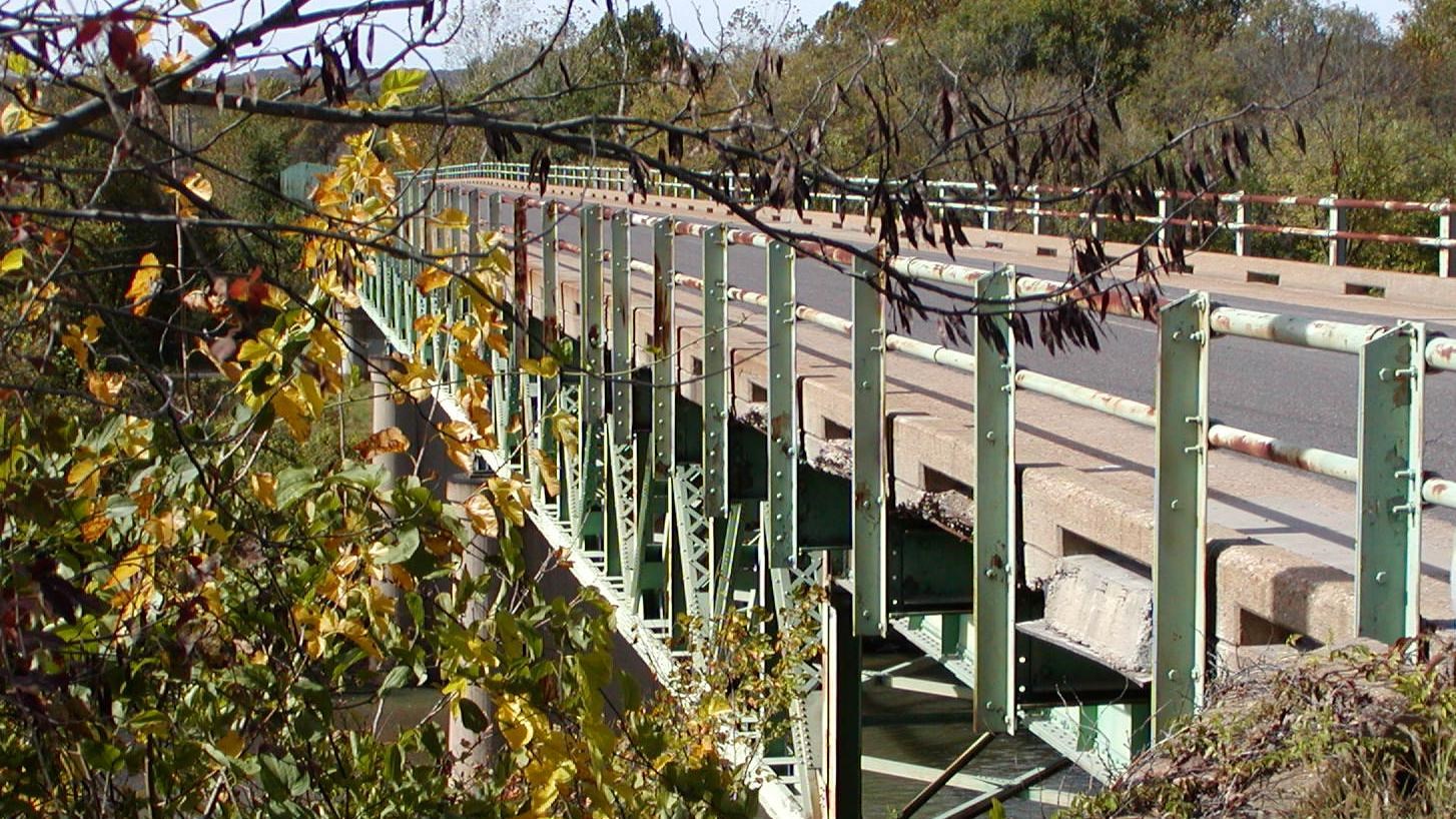
Route 66 was rerouted from Gravois Road to Chippewa in southern St. Louis in 1931, requiring a Meramec River crossing. The Meramec River U.S. 66 Bridge that resulted is a 1009-foot-long 30-foot-wide steel structure, and the Bureau of Bridge engineers employed a Warren deck truss type in its design. Truss bridges use a triangular placement of beams to stiffen and strengthen the roadbed.
Horizontal “chords” at the top and bottom of the bridge’s sides are connected by vertical posts and diagonals. Abutments are used to provide additional support. Truss patterns work very well with metal materials, and the type became popular in the middle of the 1800s, when iron was commonly used in bridge construction. James Warren and Theobald Manzani patented the Warren truss, defined by its placement of the chords to create equilateral triangles, in 1848. The bridge’s type makes it a rarity in Missouri, whose flat rivers often provide insufficient clearance for this type of structure. Most of Missouri’s few deck truss bridges were constructed in the 1920s and 1930s and all were designed by the state highway department. Only four rigid-connected Warren deck truss bridges remain in the state, including the Meramec River U.S. 66 Bridge, which builders completed in 1932.
The bridge supported subsequent development of the area. During the Depression, Times Beach transitioned into a permanent community because of the relative affordability of its small homes. In the 1940s, as commuting supported by the bridge became a popular option and river-based recreation developed further, more people moved to this section of shoreline. Times Beach incorporated in 1954, and the state added an auxiliary bridge for eastbound traffic two years later. By the late 1960s, construction of Interstate 44 had begun and traffic was permanently rerouted to the 1956 bridge relegating the Meramec River U.S. 66 Bridge to local traffic. By 1985 Route 66 was entirely decommissioned in the state. Interest in the road remained, however, and sparked Missouri's 1999 creation of the Route 66 State Park. The 419-acre park interprets and showcases the surrounding environment and portions of Route 66 within its boundary, including the Meramec River U.S. 66 Bridge. Although listed on the National Register of Historic Places in 2009. That same year, the bridge was closed to all traffic by the Missouri Department of Transportaton (MoDOT). In 2010, the bridge decking was removed to preserve the support structure by taking the weight off the aging truss. MoDOT) had plans to demolish the remaining bridge structure if a viable redevelopment plan was not in place by the end of 2016. Thanks to a collaborative effort and financial gifts from donors, Landmarks Association and Philip and Judith Stupp, fundraising efforts are underway to explore options to rehabilitate the bridge. Missouri State Parks is now the owner of the bridge.
The Meramec River U.S. 66 Bridge is located approximately two miles east of Eureka, MO, within the Route 66 State Park along the historic alignment of Route 66. The Meramec River separates the visitor center and east side of the bridge from the bulk of the park and the west side of the bridge. To access the east side of the bridge, take Interstate 44 exit 266/Lewis Rd. and follow the signs to the park. To access the west side of the bridge, take Interstate 44 exit 265/Williams Rd. and follow signs to the park. Exit 265 is accessible only to eastbound traffic, so cars traveling west will need to first take exit 264 to reverse direction.
Call 636-938-7198 or visit the Route 66 State Park website or savethisbridge.org for more information.
Site Information
Location (Old U.S. Hwy 66 Eureka, MO 63025)