Last updated: October 5, 2022
Place
Los Alamos Wayside: Hispano Communities
NPS
Quick Facts
Location:
Kwage Mesa Trail
MANAGED BY:
Amenities
1 listed
Historical/Interpretive Information/Exhibits
Main Text
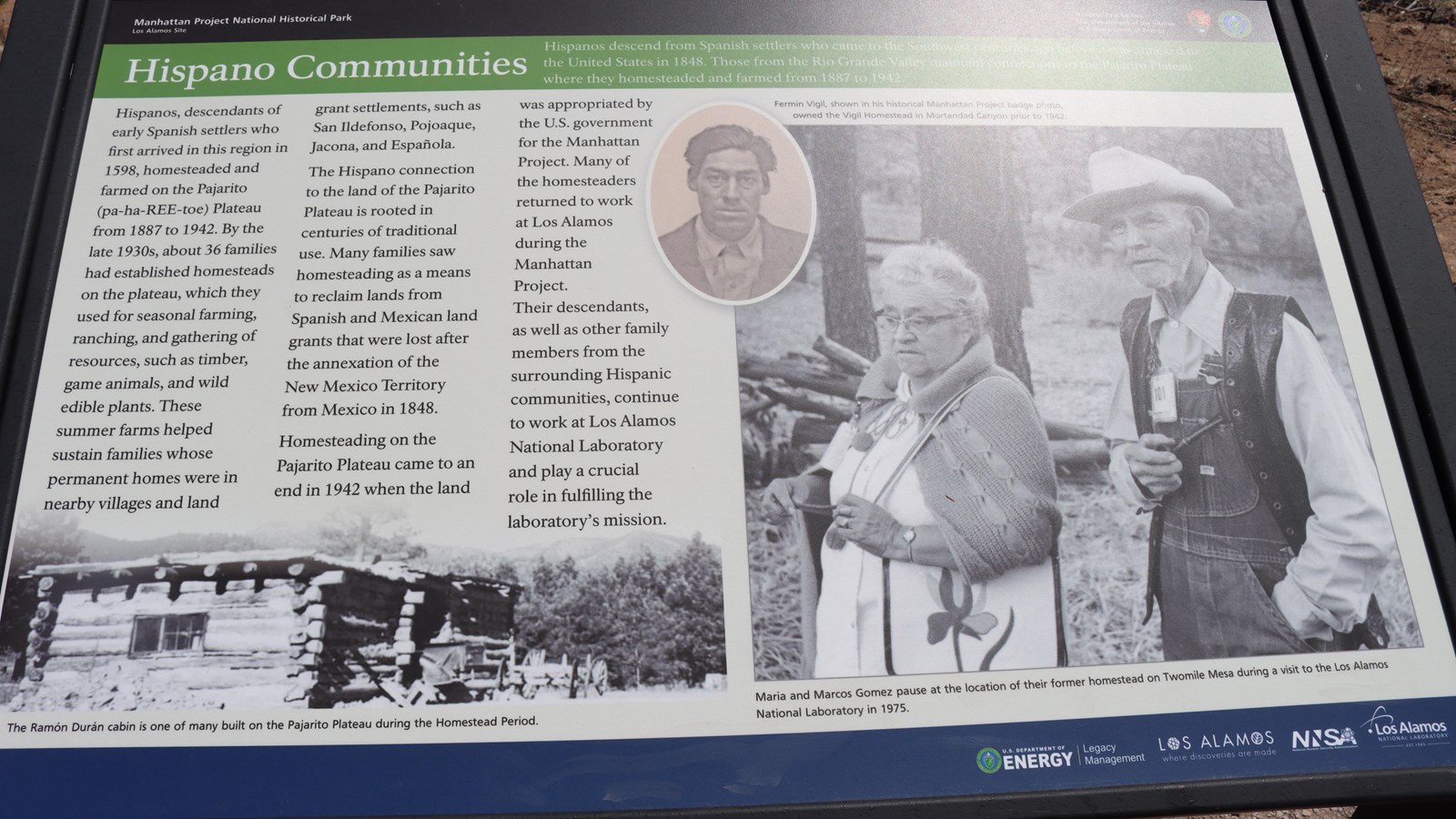
Hispano Communities – Hispanos descend from Spanish settlers who came to the Southwest centuries ago before it was annexed to the United States in 1848. Those from the Rio Grande Valley maintain connections to the Pajarito Plateau where they homesteaded and farmed from 1887 to 1942.
Hispanos, decedents of early Spanish settlers who first arrived in this region in 1598, homesteaded and farmed on the Pajarito (pa-ha-ree-toe) Plateau from 1887 to 1942. By the late 1930s about 36 families had established homesteads on the plateau, which they used for seasonal farming, ranching, and gathering of resources, such as timber, game animals, and wild edible plants. These summer farms helped sustain farms helped sustain families whose permanent homes were in nearby villages and land grant settlements, such as San Ildefonso, Pojoaque, Jacona, and Española. The Hispano connection to the land of the Pajarito Plateau is rooted in centuries of traditional use. Many families saw homesteading as a means to reclaim lands from Spanish and Mexican land grants that were lost after the annexation of the New Mexico Territory from Mexico in 1848. Homesteading on the Pajarito Plateau came to an end in 1942 when the land was appropriated by the U.S. government for the Manhattan Project. Many of the homesteaders returned to work at Los Alamos during the Manhattan Project. Their descendants, as well as other family members from the surrounding Hispanic communities, continue to work at Las Alamos National Laboratory and play a crucial role in fulfilling the laboratory’s mission.
Exhibit Panel Description
A black band at the top of the wayside says, “Manhattan Project National Historical Park Los Alamos, New Mexico” On the right of the black band is the National Park Service log o and the U.S. Department of Energy logo. Below the black band a green band has the title of this wayside, “Hispano Communities.” At the bottom left a black and white image of a rustic, log cabin. Text below the image says, “The Ramón Durán cabin is one of the many built on the Pajarito Plateau during the Homestead Period.” At the top of the right side of the wayside in an oval is a photo of a man with dark hair in a suit jacket. Text to the right of the oval reads, “Fermin Vigil, shown in his historical Manhattan Project badge photo, owned the Vigil Homestead in Mortandad Canyon prior to 1942.” Also, on the right side of the wayside is a lage black and white photo of a woman with glasses in a sweater and a man wearing a cowboy hat and overalls with a vest. Text below the image reads, “Maria and Marcos Gomez pause at the location of their former homestead on Twomile Mesa during a visit to the Los Alamos National Lab in 1975.” A blue bar at the bottom has “U.S. Department of Energy | Legacy Management, Los Alamos Where Discoveries Are Made, NNSA, and Los Alamos National Laboratory.”
Visit This Exhibit Panel
This wayside is located along the Kwage Mesa Trail. The Kwage Mesa stretches out on the north side of Los Alamos. To get to the trailhead from 15th Street and Central Avenue in downtown Los Alamos, head west (towards the Jemez Mountains) on Central. In 0.8 miles (1.28 km), past Ashley Pond, and the Aquatic Center, turn right onto Diamond Drive. Pass the Los Alamos High School and the Los Alamos Golf Course to the San Ildefonso roundabout located 2.4 miles (3.86 km) from the intersection of Central and Diamond. Bear right on San Ildefonso. Head south, then east on this road, passing the Los Alamos Middle School. About 0.1-mile (0.16 km) past North Mesa Road on the left, turn left onto an unnamed road heading toward the stable area. The road swings to the right and ends at a parking area at the North Mesa Tennis Courts. The trailhead is on the left of the playlot.