Last updated: May 31, 2024
Place
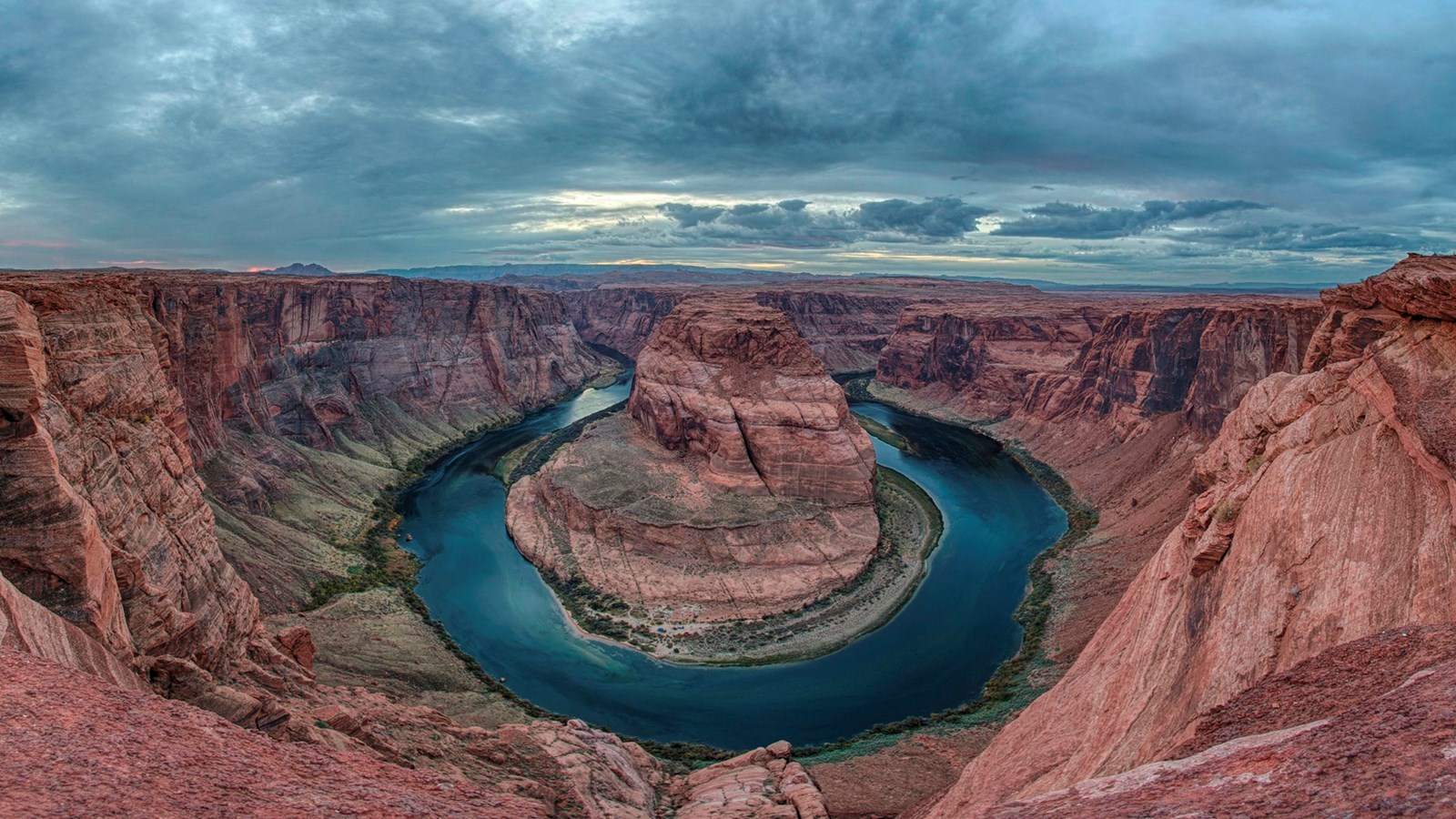
Horseshoe Bend on the Colorado River
NPS / Brent&Dawn Davis
Quick Facts
Location:
US Highway 89 in Arizona, between mile markers 545 and 544.
Significance:
Geologic wonder
Amenities
10 listed
Parking - Auto, Parking - Boat Trailer, Parking - Bus/RV, Restroom, Restroom - Accessible, Scenic View/Photo Spot, Toilet - Vault/Composting, Trailhead, Trash/Litter Receptacles, Wheelchair Accessible
A social media darling, Horseshoe Bend has become one of the most recognized and visited places in Glen Canyon National Recreation Area. The parking lot and trailhead is located off US Highway 89, approximately 5 miles (8 km) south of the Carl Hayden Visitor Center.
Changes are underway in this busy and beautiful place, including expanded parking and trail maintenance. Please respect construction closures. Much of the rim remains exposed, so watch your footing and keep track of children.
Hiking
The hike to the overlook is 1.5 miles (2.4 km) round-trip over a hardened path. The trail is accessible under the regulations of the Americans with Disabilities Act. There are two shade strctures along the length of the trail, but not at the overlook. There are railings at the edge of the overlook's viewing platform, but not along the trail.
As with any hike, be prepared with plenty of water, sturdy footwear, sunscreen, and other basic hiking essentials. Know that there is little shade along the Horseshoe Bend Trail. Avoid hiking during the hottest part of the day.
Where Am I?
Horseshoe Bend has been featured as a landmark for Glen Canyon National Recreation Area, Grand Canyon National Park, the Cities of Page AZ, Kanab UT, St George UT, and the Navajo Nation. Boundary lines are very close in some places. Horseshoe Bend itself, and that part of the Colorado River, are a part of Glen Canyon National Recreation Area. About nine miles downstream is where Grand Canyon National Park begins. US Highway 89, the land north of the trail to the Horseshoe Bend overlook, and the parking area for the trailhead are in the City of Page. The land south of the parking area and the trail and overlook are on the Navajo Nation. This mixture of jurisdictions provides a unique opportunity in the management of this magnificent trail and overlook.
An Entrenched Meander
Below the rim, the Colorado River makes a wide sweep around a sandstone escarpment. On its long downward journey to the sea, the river meandered, sometimes making wide bends, but always seeking the path of least resistance. Around 5 million years ago, the Colorado Plateau uplifted and the meandering rivers that crossed the ancient landscape were trapped in their beds. Over time, the rivers cut through the uplifted layers of sandstone.
Here at Horseshoe Bend, the Colorado River created a roughly 1,000 ft (305 m) deep, 270º horseshoe-shaped bend in Glen Canyon.
Parking Fees
Horseshoe Bend itself is in the park, but the parking lot is on city land. The City of Page requires visitors to pay for parking at the Horseshoe Bend trailhead. National Park Service passes do not apply for the parking lot. Contact the City of Page for questions about the parking at Horseshoe Bend at their website here.
PLEASE NOTE: On Holidays and busy weekends, the City of Page may require all visitors to use a shuttle to visit once the parking lot is full. Check with them if you plan to visit during busy times.