Last updated: March 12, 2026
Place
California: Foothill Boulevard Milestone (Mile 11)
Photo/TheCatalyst31
Quick Facts
Location:
1320 E Colorado Blvd Pasadena, CA 91106
Significance:
Historic marker along Route 66
Designation:
National Register of Historic Places
Amenities
1 listed
Historical/Interpretive Information/Exhibits
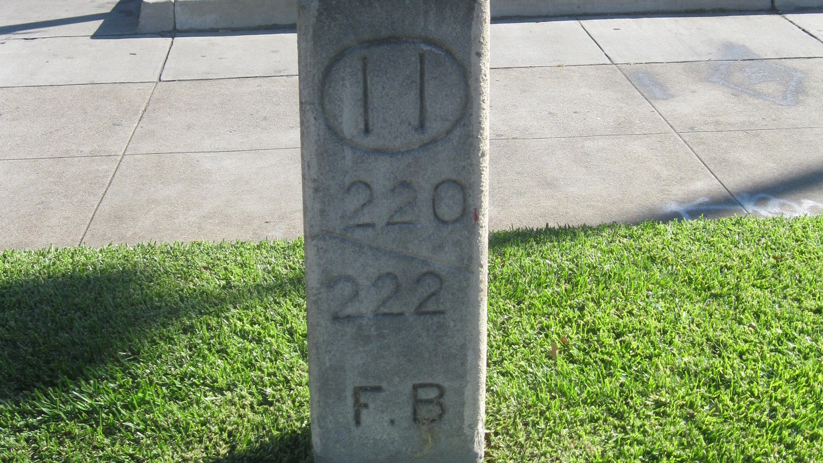
That is not a gravestone in the grass between the street and the sidewalk, though many motorists are fooled at first glance. At 12 inches wide, six inches thick, and three and a half feet high, the concrete tablet with its rounded top would not look out of place in a cemetery. This cement sign never marked a place of rest though, rather, it marked a city on the move. The Foothill Boulevard Milestone, also known as the Bancroft Marker, is one of Pasadena’s earliest mileposts.
The milepost’s block numbers distinguish it as part of the Bancroft system. Albert Bancroft wanted to help motorists locate residences, businesses, property boundaries, and postal delivery addresses, so he developed a system to divide road miles into 10 conceptual blocks with variations of block numbers as addresses (e.g. 220, 220a, 220b, 220c, etc.). Bancroft envisioned that the system would be used for maintaining voting records, taking censuses, and calculating mileage and gasoline consumption. The Bancroft system debuted in Contra Costa County in 1892. In Pasadena, the old Los Angeles County Courthouse was the system’s locus, and the Foothill Boulevard Milestone’s circled “11” told motorists how many miles they were from it. The block numbers beneath the circle, in this case 220 and 222, indicate how far along mile 11 they had driven.
Workers placed the markers as part of a turn-of-the-century road improvement project of the Highway Commission of Los Angeles County. At the beginning of the 1900s, civic promoters and advocates of the “Good Roads” movement recognized modern road systems as the key to commerce and tourism. Road improvements were hot topics, including road markers, signage, pavement, streetlights, lane width, and bridges. Founded in 1899, the Pasadena Better Road Society and the Pasadena Auto Club advocated locally for roadway improvements. Between 1902 and 1908, the Highway Commission of Los Angeles responded to the demand by measuring six routes within Los Angeles County and marking them with the Bancroft milestones. Pasadena abandoned the system in 1908 however, just two years after its implementation. Today, the milestone at the junction of Holliston Avenue and East Colorado Boulevard on the Foothill Boulevard route is the only marker that remains. The National Park Service listed the milestone in the National Register of Historic Places in 1996.
The Foothill Boulevard Milestone is just south of 1308 East Colorado Blvd., west of the intersection with Holliston Ave. in Pasadena, CA.
Site Information
Location (1320 E Colorado Blvd Pasadena, CA 91106)