Last updated: July 8, 2020
Place
Dana Common
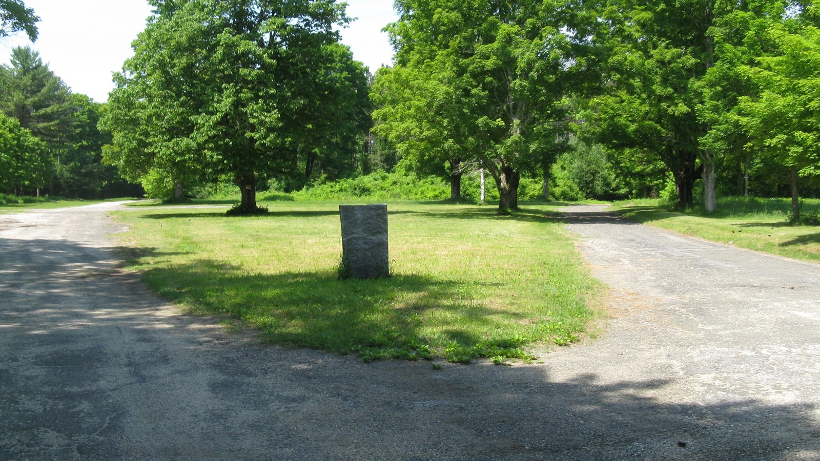
Photo by John Phelan, CC BY 3.0, https://commons.wikimedia.org/w/index.php?curid=9569575
Quick Facts
Location:
Route 32A in Petersham, MA
Significance:
Dana Common is a preserved archaeological landscape reflecting the 19th century organization and land uses of a Swift River Valley town before the development of the Quabbin Reservoir in the 1930s.
Designation:
National Register of Historic Places
Dana Common is a preserved archaeological landscape reflecting the 19th century organization and land uses of a Swift River Valley town before the development of the Quabbin Reservoir in the 1930s. Although no buildings remain at Dana Common, extant foundations and cellar holes, granite steps, fragments of paving, stone fenceposts, walls, and a metal safe too big and heavy to relocate survive, all reflecting a world that is now gone.
Dana Common was formerly the institutional center of the once-vibrant town of Dana. The Commonwealth of Massachusetts acquired the town of Dana along with three adjacent central Massachusetts towns—Enfield, Greenwich, and Prescott—to create the Quabbin Reservoir, which, by the mid 20th century, would become the major source of drinking water for about two million people in and around Boston. Dana was among the four towns disincorporated, leveled, and flooded by the damming of the Swift River in 1939. The Dana Common area, on the East Branch of the Swift River, was above the reservoir flow line in the watershed and so was never inundated. Today the Quabbin Reservoir is the largest inland body of water in the Commonwealth, and said to be one of the world’s largest domestic water supplies. Dana Common is the best-preserved and most easily accessible of the former villages that made up the pre-Quabbin, Swift River Valley towns.
When first settled in the mid 18th century, largely agrarian Dana was part of the towns of Hardwick and Petersham. Dana became a separate town in 1801, and at first, Dana town meetings alternated between sites in three small village settlements: Doubleday, North Dana, and, in the very south of the town, the future Dana Center. In 1842, a fourth village was annexed to the new town, Storrsville to the southeast, which suddenly made Dana Center less an outlier village and thus encouraged institution building. Dana Center now was truly near the town’s geographic core, and its period of growth began. Dana Common also marked the intersection of five roads, which led to Barre and Petersham to the east, North Dana to the north, Greenwich to the southwest, and Hardwick to the south.
Most of Dana’s earliest buildings were constructed around the small, triangular Common in the decade and a half between 1840 and 1855. The town store and post office, the former Baptist meetinghouse purchased and relocated from Petersham to become Dana’s town hall and first school room, and the hotel and tavern all brought commercial activity to the village. There were also the Congregational Church, two cemeteries, several smaller stores and workshops, and about two dozen modest and high-style residences and barns. This growth was mirrored in the town’s population, which increased 18% between 1830 and 1860, reaching its all-time high of 876 people. Beginning in the second half of the19th century, Dana was also a popular destination for summer visitors and retirees from more urban areas who were drawn to the picturesque rural village. But development at the center was brief, slowing with the arrival of the railroad at North Dana in 1873. Although a school was built next to the town hall in 1892, very little new construction occurred in the vicinity of the Common after 1870. The village that was present when preparations for the creation of the Quabbin began was physically little changed from that which had developed in the middle decades of the 19th century.
While the work of forming the Quabbin Reservoir began in the 1920s, the taking of the Swift River to supply Metropolitan Boston’s vast water needs had been discussed as early as 1896 by the Massachusetts legislature. Water became more urgent after several particularly dry years during World War I. The first serious investigation of the potential of central Massachusetts’ rivers was ordered in 1918, and by 1919, it was apparent that the towns of the Swift River Valley faced a real possibility of at least partial inundation. After a decade of arguments and counterarguments, surveys and resurveys, the Massachusetts legislature adopted a plan that would take water from the rivers to fuel the needs of metropolitan Boston, and created the Metropolitan District Water Supply Commission to oversee the project. Some residents left town at the beginning of the discussions, quickly selling their homes and moving elsewhere. Others stayed as long as possible.
As part of the Quabbin’s creation, all buildings were to be removed. The cemeteries were recorded and then emptied, with remains reinterred in the new Quabbin Cemetery in the nearby town of Ware. An important aspect of the preparations was the documentation that took place between 1927 and 1930. As part of the project, all buildings and structures were mapped, photographed, and catalogued before their removal, with the result being a remarkable record of an area that would soon be obliterated.
Dana’s last town meeting was held in March 1938 and the school closed that June after a final graduation ceremony. By the end of the year, the last resident had moved away. The Swift River, diverted during the construction of the great Winsor Dam, a key component of the Quabbin, between 1935 and 1939, began to fill the reservoir in August 1939. Quabbin reached its full capacity in 1946.
The Metropolitan District Water Supply Commission was abolished in 1947 and its functions transferred to the Metropolitan District Commission (MDC), which would guide the management of the Quabbin for another half century. Management included planting and clearing of forest lands to control erosion and water runoff. The MDC itself would be abolished in 2003 and its functions transferred to the Massachusetts Department of Conservation and Recreation (DCR).
The Dana Common Historic and Archaeological District was listed in the National Register in 2013. The district designation recognizes an area whose buildings are gone, but whose landscape, with its foundations, cellar holes, stone walls, fenceposts, and open spaces, continues to reflect the town’s history.
The area today is characterized by woods, fields, brooks, stone walls, and a network of dirt and paved roads, and includes the sites of approximately thirty former buildings. The area around Dana Common is the best-preserved village site in the four towns and the most easily accessed. The cemetery site and common, as well as the sites of the former buildings, are kept open to interpret and memorialize Dana Center and the towns taken by the state. DCR manages the Quabbin Reservoir lands, which are open to the public for hiking, cycling, and fishing, and other recreational and educational activities. Dana Common remains a place whose landscape provides an evocative and moving record of its past history.
Dana Common is located 1.7 miles down the road from Gate 40, off Route 32A in Petersham. The Quabbin Visitor Center is located at 485 Ware Road (Route 9) Belchertown, MA 01007.
For more information on Dana Common and on the history of the water supply system in Massachusetts, visit the Massachusetts Department of Conservation and Recreation website.
To discover more Massachusetts history and culture, visit the Massachusetts Conservation Travel Itinerary website.