Last updated: December 30, 2021
Place
Clark’s Canoe Camp on the Yellowstone
Quick Facts
Location:
Montana
OPEN TO PUBLIC:
No
Lewis and Clark NHT Visitor Centers and Museums
This map shows a range of features associated with the Lewis and Clark National Historic Trail, which commemorates the 1803-1806 Lewis and Clark Expedition. The trail spans a large portion of the North American continent, from the Ohio River in Pittsburgh, Pennsylvania, to the mouth of the Columbia River in Oregon and Washington. The trail is comprised of the historic route of the Lewis and Clark Expedition, an auto tour route, high potential historic sites (shown in black), visitor centers (shown in orange), and pivotal places (shown in green). These features can be selected on the map to reveal additional information. Also shown is a base map displaying state boundaries, cities, rivers, and highways. The map conveys how a significant area of the North American continent was traversed by the Lewis and Clark Expedition and indicates the many places where visitors can learn about their journey and experience the landscape through which they traveled.
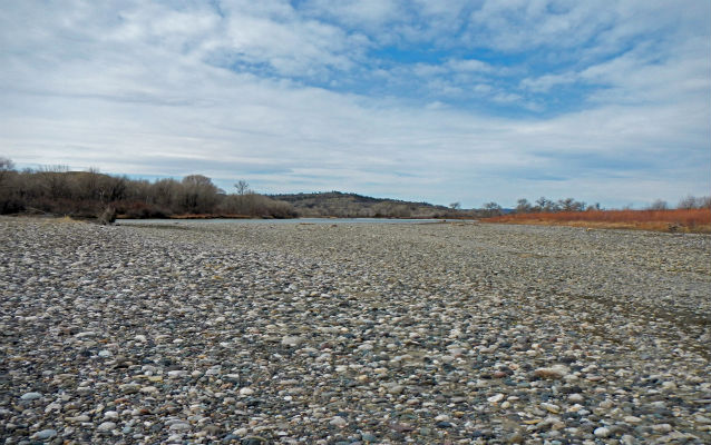
On the return journey, Clark’s party traveled about 100 miles down the Yellowstone River before they finally found cottonwood trees large enough for building canoes and made camp on July 19, 1806. George Gibson had suffered a serious thigh injury after being thrown from his horse, making land travel for him all but impossible. Clark wrote that they “found some large timber near which the grass was tolerably good I Encamped under a thick grove of those trees which was not Sufficiently large for my purpose.” However, there were no better trees in the vicinity to be found. The next day Clark “deturmined to have two Canoes made out of the largest of those trees and lash them together which will Cause them to be Study and fully Sufficient to take my Small party & Self with what little baggage we have down this river.” The party remained at the camp until July 24 building the canoes, hunting, and stitching new clothing from deer and elk skins. One night half of their horses disappeared. While Clark suspected it to be the work of an element from the Crow Tribe, no Crows were ever encountered and the missing horses were never recovered.
Based on geographical analysis and an archeological study conducted between 2011 and 2014, Clark’s Canoe Camp site is likely located near present day Park City, Montana. The published report identified – among other things – a fire feature, localized mercury deposits, and a lead ball consistent with the type available to the expedition.