Last updated: October 10, 2024
Place
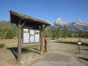
Taggart Lake Trailhead
Quick Facts
Amenities
3 listed
Historical/Interpretive Information/Exhibits, Restroom, Wheelchair Accessible
Location: Access the Taggart Lake trailhead from the Teton Park Road three and a half miles northwest from Moose Junction.
Notes: Visitor services include a modest-sized parking lot, a vault toilet, map brochure box, bike rack and a trailhead sign. Remember to bring water with you. Bears may be active any place and at any time-travel in groups, make noise and carry bear spray. Backcountry camping requires a permit-pick one up at a backcountry permits office.
Destinations
The Taggart Lake area offers several loop trail options. Head west toward the mountains, climb a glacial moraine mantled in aspen and lodgepole pines and descend to Taggart Lake. This glacial lake lies at the mouth of Avalanche Canyon.
From Taggart Lake, you may continue north to reach Bradley Lake, another glacial lake at the mouth of Garnet Canyon. To complete the loop, continue south along the Valley Trail. If you venture beyond Bradley Lake you can intersect the Lupine Meadows trail.
Taggart Lake
3.0 miles RT, 2 hours, 350 ft total climbing, Easy.
Out-and-back trail traverses sagebrush flats and forests to a lake with views of the Grand Teton.
Taggart Lake-Beaver Creek Loop
3.9 miles RT, 2 hours, 500 ft total climbing, Moderate.
Hike this trail to the lake, climb the glacial moraine and return along Beaver Creek.
Taggart Lake-Bradley Lake
5.9 miles RT, 3 hours, 800 ft total climbing, Moderate.
Loop hike visits two lakes dammed by glacial moraines.
Name Origin
Named for W. Rush Taggart, the assistant geologist with the 1872 Hayden Expedition. Taggart first came to Jackson Hole in 1860 with Captain W.F. Raynolds and the army engineers.