Last updated: October 10, 2024
Place
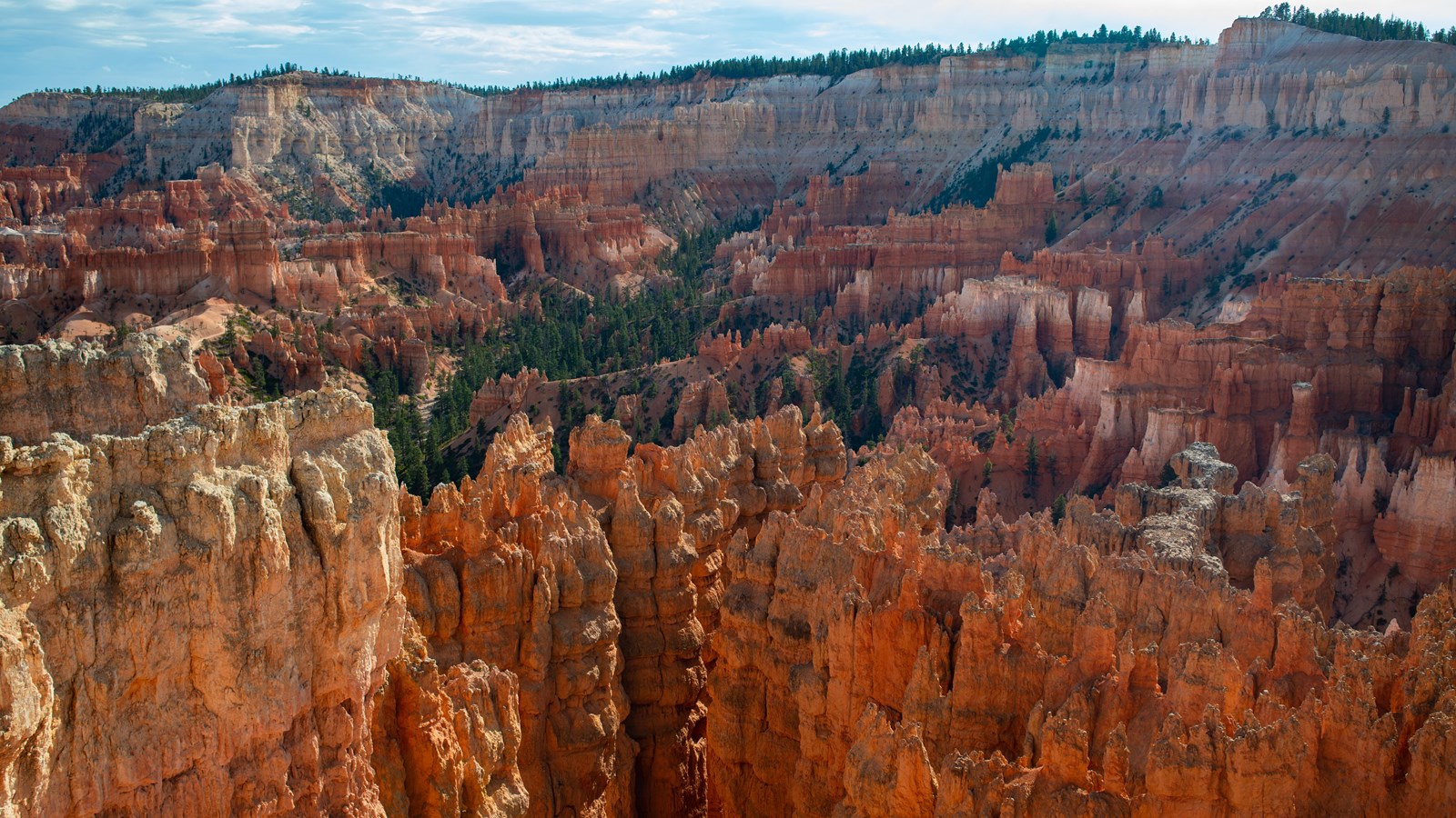
Sunset Point
NPS Photo / Peter Densmore
Quick Facts
Location:
Mile 2.25 of the 18 mile main park road
Significance:
One of 4 major viewpoints of the Bryce Amphitheater
Amenities
8 listed
Bicycle - Rack, Historical/Interpretive Information/Exhibits, Picnic Table, Restroom, Trailhead, Trash/Litter Receptacles, Water - Drinking/Potable, Wheelchair Accessible
Sunset Point offers vistas of some of the most famous and breathtaking of Bryce Canyon's hoodoos. Few places are the colors of Bryce Canyon's rock better displayed than from Sunset Point. Called the Claron Formation, this unique rock is primarily composed of limestone deposited approximately 50 million years ago in a large freshwater lake, known to geologists as Lake Claron. Iron oxide minerals supply the vibrant red, oranges, and yellows of the lower half of the cliffs which geologists call the Pink Member. As its geologic names suggest, here too patches of pink and purple caused by manganese oxides add to the rainbow of color. The change from orange to white marks the beginning of the Upper Member. This section of limestone is purer; its lack of color is caused by the absence of mineral impurities.
Trails
The 5.5 mile (8.9 km) Rim Trail connects this view to Sunrise and Fairyland Points further north and Inspiration and Bryce Points further south. The most popular section is the 0.5 mile (0.8 km) section between here and Sunrise Point. This section is paved (and therefore permits leashed pets) and has minimal elevation changes. The Navajo Loop Trail also descends from this viewpoint area.
Landscape Features
To the North
A 0.5 mile (0.8 km) walk away, Sunrise Point rises gently along the rim, and Boat Mesa extends beyond the ridgeline of the Queen's Garden Trail's gentle descent from it.
To the East
The horizon is graced with the grandeur of the Table Cliff plateau, whose notched southern end (known as Powell Point) stands 13 miles distant and 2,000 ft (607 m) above you. Further off to the south, the rounded dome of Navajo Mountain rises 80 miles distant. Within the boundary of the park, the tilted layers of Sinking Ship reveal the location of the Paunsaugunt fault. See the Geology section for more information. Nearly directly below the viewpoint, the park's most famous hoodoo, Thor's Hammer stands. It is perhaps best seen along the Two Bridges side of the Navajo Loop. To the south, the rim rises toward Inspiration and Bryce Points. Below stands the fantastic maze of the Silent City, into which the Navajo Loop descends. Nowhere are the colors of Bryce Canyon's rock better displayed than from Sunset Point. Called the Claron Formation, this unique rock is primarily composed of limestone deposited approximately 50 million years ago in a large freshwater lake, known to geologists as Lake Claron. Iron oxide minerals supply the vibrant red, oranges, and yellows of the lower half of the cliffs which geologists call the Pink Member. As its geologic names suggest, here too patches of pink and purple caused by manganese oxides add to the rainbow of color. The change from orange to white marks the beginning of the Upper Member. This section of limestone is purer; its lack of color is caused by the absence of mineral impurities.