Last updated: November 29, 2022
Place
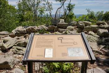
Information Panel: Stone Fort
Quick Facts
Amenities
1 listed
Historical/Interpretive Information/Exhibits
To command Maryland Heights' highest point, the Federals built this massive foundation, called the Stone Fort, in the winter of 1862-1863.
Union engineers designed this defense as an infantry blockhouse to ward off Confederate attack along the crest. The Northerners completed the blockhouse foundation but never constructed a superstructure. By September, 1863, the Union garrison had transformed the Stone Fort into a commissary and storage area.
During an inspection by Brig. Gen. Max Weber in April 1864, the Stone Fort was described as "surrounded with a wall of solid stone, containing rations for five thousand men, [and] only covered with boards." - a practical but unfitting use for this imposing structure.
Illustration Caption: The original plan for the Stone Fort, October 10, 1862, designed by military engineer Lt. Charles Suter.
Illustration Caption: In plan view, as drawn by archaeologists, the Stone Fort consists of a rectangular stone foundation, 100' x 40', flanked by two stone bastions. The soil-filled fort contrasts with the exposed bedrock along the nearby crest.
Map Caption: An 1863 sketch, by George Kaiser, of the military fortifications around Harpers Ferry. The Stone Fort complex is identified as a red rectangle, dominating the crest of Maryland Heights.