Last updated: October 10, 2024
Place
Signal Mountain Trailhead
Location: Access the Signal Mountain trail through the Signal Mountain campground or drive up the Signal Mountain Summit Road about one mile. Park near the pond and backtrack down the road to cut around the pond to the south.
Notes: This trail is lightly traveled. If you park near the Signal Mountain Lodge or Campground, you will have access to restrooms, water and a store. If you drive up the Signal Mountain Road to begin your hike, there are no facilities. Bears may be active any place and at any time-travel in groups, make noise and carry bear spray. This trail does not access backcountry camping areas.
Destination
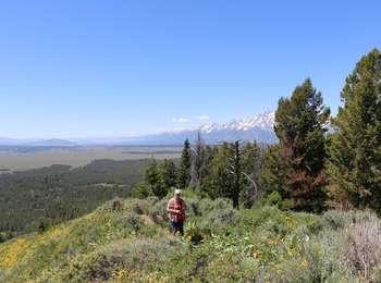
While most visitors drive to the summit, a moderate hiking trail will allow you to avoid the crowds!
6.8 miles RT loop, 4 hours, 850 ft total climbing, Moderate.
Traverse forests to viewpoint. Park at Signal Mountain Lodge and walk on park road to trail or cut through the campground to reach the trailhead.
Name Origin
In 1891, Robert Ray Hamilton went missing while hunting in Jackson Hole. Searchers agreed to light a signal fire on the summit of this mountain when he was found. Seven days later, Hamilton's drowned body was found in the Snake River two miles below Jackson Lake Dam. His partner, John D. Sargent, was a suspect in Hamilton's demise.