Last updated: February 17, 2021
Place
SCA Trailhead
NPS
Quick Facts
Amenities
1 listed
Trailhead
A hike along the SCA Trail will provide a breathless vista of the Golden Gate Bridge and the surrounding Bay. When the sun is shining and the fog is lifted, hiking along this trail will make memories that will last a lifetime. Experience what the Golden Gate Bridge looks like from this north side!
The well-maintained trail is cut into the side of the mountain and faces westward.
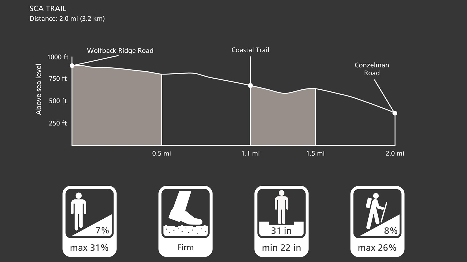
SCA Trail Overview
Distance: 2.0 miles (3.2 km, one-way)
Time: 1 hour
Trailhead: SCA Trail
Slope: Avg 8%, Max 26%
Side Slope: Avg 7%, Max 31%
Width: Avg 31 in., Min 22 in.
Trail Surface: Firm
Safety
- Stay on the established trail. Keep an eye out for poison oak.
- Observe warning signs and railings-these exist for your safety.
- Dress in layers and be prepared for varying weather conditions. Sunny days along the coast can turn windy, foggy, and cold very fast.
- Do not climb on the coastal bluffs or edges, the sand and rocks are loose and eroding and dangerous!
- People have fallen from these cliffs -- and died!
Parking
There is parking at the southern trailhead, along Conzelman Road.
Dog and Trail Etiquette
Dog walking is allowed in areas for on-leash or voice/sight control. Off-trail travel harms plants and causes erosion. Keep your food within arm's reach at all times and do not feed the wildlife. Carry out all trash and food waste (fruit peels, shells, etc.).
The well-maintained trail is cut into the side of the mountain and faces westward.
SCA Trail Overview
Distance: 2.0 miles (3.2 km, one-way)
Time: 1 hour
Trailhead: SCA Trail
Slope: Avg 8%, Max 26%
Side Slope: Avg 7%, Max 31%
Width: Avg 31 in., Min 22 in.
Trail Surface: Firm
Safety
- Stay on the established trail. Keep an eye out for poison oak.
- Observe warning signs and railings-these exist for your safety.
- Dress in layers and be prepared for varying weather conditions. Sunny days along the coast can turn windy, foggy, and cold very fast.
- Do not climb on the coastal bluffs or edges, the sand and rocks are loose and eroding and dangerous!
- People have fallen from these cliffs -- and died!
Parking
There is parking at the southern trailhead, along Conzelman Road.
Dog and Trail Etiquette
Dog walking is allowed in areas for on-leash or voice/sight control. Off-trail travel harms plants and causes erosion. Keep your food within arm's reach at all times and do not feed the wildlife. Carry out all trash and food waste (fruit peels, shells, etc.).