Last updated: May 21, 2024
Place
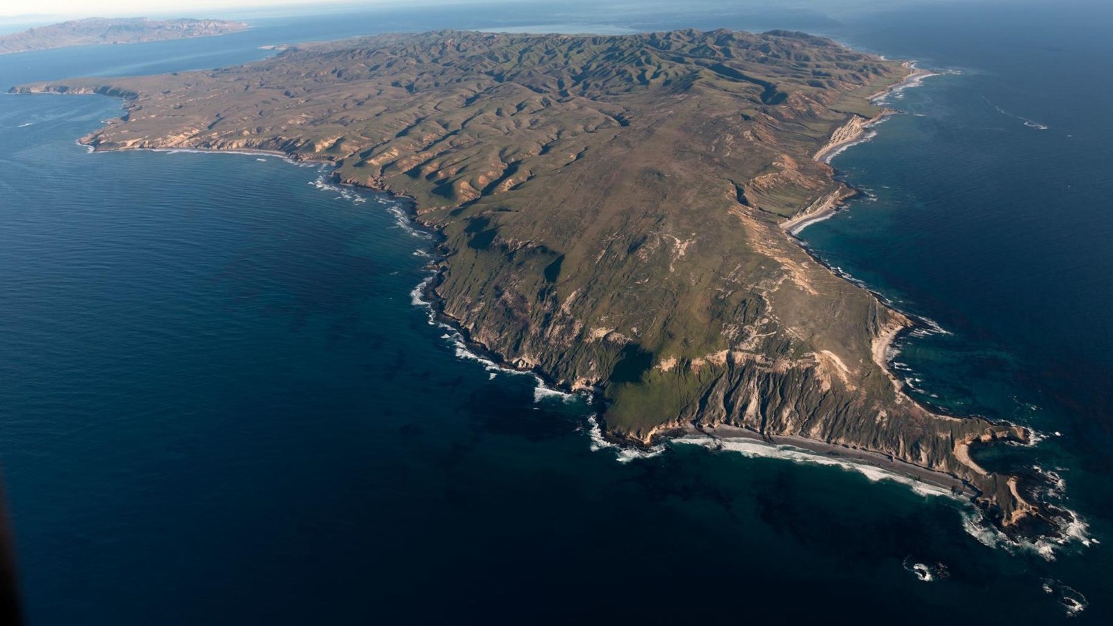
Santa Rosa Island — wima
Carol M Highsmith,
wima is the Chumash word for Santa Rosa Island It means redwood, specifically Sequoia Pino Colorado. helwaškuy is another name for the island as well as a village on the island. It means 'something in the middle of two other things,' as wima is between tuqan and limuw.
Please see "Ethnographic Island Place Names" below for more information on island place names.
Santa Rosa Island was included as part of Channel Islands National Park upon the park's inception on March 5, 1980. However, it wasn't until December 1986 that the island came under the ownership of the National Park Service.
Located 40 nautical miles from the Channel Islands National Park visitor center in Ventura, Santa Rosa is the second largest island in California at approximately 53,000 acres in size. The island's relatively low profile is broken by a high, central mountain range, rising 1,589 feet at its highest point. Its coastal areas are variable, ranging from broad, sandy beaches gently sloping toward a dynamic ocean to sheer cliffs plunging toward the turmoil of a sea intent on changing the contour of the land.
As on its larger neighbor, Santa Cruz Island, these varied landforms support a diverse array of plant and animal species. About 500 plant species can be found within nine plant communities, including six plant species found only on Santa Rosa and nowhere else in the world. One of these species, the Santa Rosa Island subspecies of Torrey pine, is considered one of the rarest pines in the world-the last enduring members of a once widespread Pleistocene forest. A remnant, mainland subspecies of Torrey pine also can be found near La Jolla, California, at Torrey Pines State Reserve. Santa Rosa Island also hosts over 100 bird and three mammal species (including the island's largest native mammal, the endemic island fox); two amphibian and three reptile species; and colonies of seabirds, seals, and sea lions.
Remains of an ancient endemic species, the pygmy mammoth, have been uncovered on Santa Rosa, along with Santa Cruz and San Miguel Islands. These miniature mammoths, only four to six feet tall, once roamed island grasslands and forests during the Pleistocene. The fossil skeleton discovered on Santa Rosa Island in 1994 is the most complete specimen ever found.
Along with extensive paleontological resources, Santa Rosa Island has rich archeological resources. Home to the Island Chumash until approximately 1820, wima (as the Chumash refer to the island) contains thousands of significant and federally protected archeological sites. Archeological investigations on the island have enabled scientists to construct a more complete picture of Chumash life on the islands. Radiocarbon dating on some of these sites indicates that humans have been using the island for more than 13,000 years.
Others have come to the island during more recent centuries to exploit its rich resources, sometimes making it their home. In addition to the native Chumash, European explorers, Aleut sea otter hunters, Chinese abalone fishermen, Spanish missionaries, Mexican and American ranchers, and the US military all have left their mark on the Santa Rosa landscape. Visitors can see relics of these occupations in remnants of fishing camps, water troughs and fence lines, the pier where cattle were loaded and unloaded, buildings and equipment of the historic Vail and Vickers ranch at Bechers Bay, and remains of the military installations.
Surrounding the island are cold, nutrient- rich waters that sustain a diverse web of marine life, including pelagic fish, a variety of marine mammals, and extensive kelp forests.
As on the other islands, the National Park Service has made great efforts to preserve and protect these island resources, including enforcement of marine protected areas, stabilization of cultural sites, rehabilitation of historic buildings, removal of nonnative plants and animals, recovery of island foxes, and reestablishment of bald eagles.
Island Facts
- Located in Santa Barbara County.
- Forty miles from Ventura; 26.5 miles from the nearest mainland; three miles east of San Miguel Island and six miles west of Santa Cruz Island.
- Santa Rosa is the second largest island in California. Approximately 15 miles wide by 10 miles long; 84 square miles; 53,000 acres.
- Average rainfall-15 inches.
- Radar Mountain is island's tallest peak at 1,589 ft.
- Six endemic plant species occur only on Santa Rosa Island.
- Santa Rosa Island is home to only three native terrestrial mammals-the island fox, island spotted skunk, and island deer mouse. They are all endemic to the Channel Islands.
- Reptiles and amphibians include the alligator lizard, Baja California tree frog, and three endemic species-the island gopher snake, island fence lizard, and Channel Islands slender salamander.
Things To Do
Santa Rosa Island may be visited on a one-day trip, multi-day boat trip, or an overnight camping trip. However, getting to this island is more challenging and the weather can be windy anytime of year-30-knot winds are not uncommon. Therefore, visitors must be prepared for adverse weather. As with all the Channel Islands, visiting Santa Rosa Island is an exercise in preparation and self-reliance. Since there are no services on the islands, there are no remedies for poor planning once you have arrived.
Boat Transportation
Island Packers offers trips spring through fall. Travel time is about three hours. Strong winds and rough seas are possible. Landing is at Bechers Bay via a pier. Multi-island, overnight boat trips frequently visit Santa Rosa Island as well.
Plane Service
Channel Islands Aviation offers trips year round. Travel time is about 45 minutes Landing is at a graded dirt airstrip in Bechers Bay.
Goods and Services
There are no goods, services, or accommodations (lodging) available on the island. Visitors must bring all their own food and supplies. Public phones are not available.
Water
There is water available in Bechers Bay at two locations-Water Canyon campground and the public bathrooms in the historic ranch area.
Picnicking
In Bechers Bay, picnic tables are available at Water Canyon Beach (by the road cut at the end of the airstrip) and on the grass area of the historic ranch house.
Visitor Center
There is no visitor center on the island. For information, check with island staff or the visitor center in Ventura.
Interpretive Programs
On days that the concessionaire boats or planes travel to Bechers Bay, guided hikes may be offered by national park volunteers or concessionaire naturalists. If they are not available to lead hikes, self-guided interpretive trail booklets are available. Hikes generally begin 30 minutes after the concession boats or planes arrive on the island. A variety of guided hikes may also be offered during weekends that Island Packers drops off campers.
Hiking
Several trails and roads traverse the island, providing visitors with spectacular hiking opportunities, including the relatively flat route to Water Canyon Beach to the rugged, mountainous path to Black Mountain.
Camping
Primitive camping is available at Water Canyon campground (15 sites; $15 per night per site; reservations required). Picnic table, food storage box, windbreak, pit toilet, and water are provided. The campground is a flat 1 ½-mile hike from the pier and a ¼-mile from the airstrip and Water Canyon Beach. Due to the boat schedule, minimum stay is generally three days. Backcountry camping on Santa Rosa Island is currently limited to certain beaches between August 15th and December 31st. Hiking is along the beach and rugged, unsigned dirt roads or unmaintained animal paths. The closest beach for camping is 10 miles from the boat/plane drop-off location in Bechers Bay. Backcountry camping beaches can also be accessed via kayak or boat. Water is available year round in some of the island's canyons. All campers should be prepared for a variety of weather conditions. Thirty-knot winds are not uncommon. Sturdy, low-profile tents, stakes, and line for securing tents are recommended.
Watersports
Due to the strong, persistent wind,swimming, snorkeling, diving, and kayaking are limited and recommended for the experienced visitor only. Despite the wind, Santa Rosa Island offers exceptional beach walking on white sand beaches. Access to one of the best beaches, Water Canyon Beach, is just over a mile from the pier in Bechers Bay and just down canyon from the campground. Beach access is also available near the pier. Surfing can be done at several locations on Santa Rosa Island. Generally, the north shore is best during the northwest swells of winter/spring and the south shore is best during the south swells of summer/fall. However, all surf spots are remote and are best accessed by private boat or by backcountry beachcamping due to the hiking distance from Bechers Bay.
Fishing
No fishing is allowed within the three marine reserves located around the island. Fishing is allowed outside of these areas. To fish in the park, possession of a valid California state fishing license with an ocean enhancement stamp is required and all California Department of Fish and Game regulations apply.
Wildlife/Wildflower Viewing
There is limited accessible wildlife viewing on Santa Rosa Island. A variety of common seabirds and shorebirds (cormorants, brown pelicans, gulls) can be seen throughout the year in Bechers Bay, but there is better viewing on the boat ride over. Tell boat staff you are interested in seeing seabirds and they will help keep a lookout. Given the wind, landbirds are best spotted in the canyons such Cherry and Water Canyons. Pinniped viewing is limited to remote locations on the island. Backcountry camping is required to access these spots. Island foxes and other terrestrial species are often seen. During a normal year of rainfall, wildflowers are best viewed in late winter and spring. In addition, some plants like gumplant, buckwheat, poppies, and verbena continue to bloom during the summer. Good tidepooling spots are located within Bechers Bay, including just east of the pier, the east end of Southeast Anchorage, and near East Point. Other tidepooling areas are located throughout the island but require backcountry camping to reach these areas.
History and Culture Overview
Introduction
Societal values about people, places, cultures, and our landscapes shift over time. Santa Rosa Island has a deep history that illustrates this phenomenon.
For more than 13,000 years Native American people were here, hunting, fishing, gathering, managing, and treasuring the island. The Island Chumash's economy collapsed during the Spanish Mission era and they were forced from wima (Chumash name for Santa Rosa Island) into the mission lifeways on the California mainland. Nevertheless, the Chumash people of today maintain strong cultural, spiritual, and historical ties to the island and their legacy is still embedded in the land.
Within a single generation of Island Chumash departure, the island had been granted by the governor of Alta California to the Carrillo brothers. Thus began a 150-year period of ranching, during which first sheep and then cattle roamed and grazed the island.
When Congress considered whether or not to include Santa Rosa Island as part of Channel Islands National Park, the open and undeveloped landscape perpetuated by ranching was a key determining factor in their decision. Four generations of the Vail family and their extended ranching "family" managed and cared for the island, preserving intact the last original and consistently operational Mexican land grant. The Vail family descendants of today have personal and vital connections to the island landscape and its ranching history.
Santa Rosa Island is now managed by the National Park Service on behalf of the public for its natural, cultural, historical, and wilderness values. We encourage you explore the island and experience its full complexity, as a landscape that has been loved and lived in for thousands of years and continues to provide recreation, respite, and renewal for current and future generations.
Overview
Located 26.5 miles from the closest mainland point, Santa Rosa Island is the second largest of the eight Channel Islands, with over 53,000 acres of sandy beaches, grasslands, steep canyons and occasional groves of trees, including the rare Torrey pine grove above Bechers Bay. Called wimal by the Chumash, the island's native inhabitants, Santa Rosa Island has a history of human occupation stretching back at least 13,000 years. Following the Chumash came European explorers, Chinese abalone fishers, sea mammal hunters and fisherman, as well as ranchers, sport hunters, oil companies and the military, all of them leaving traces of their use of the island
Chumash on Santa Rosa Island and European Contact
Archaeologist Phil Orr's discovery of human bones in 1959 at Arlington Springs provided evidence of the oldest known habitation of the island. Recently radio-carbon dated to 13,000 years before present, these are among the oldest securely-dated human remains in North America. The age of the Arlington remains and a host of archeological sites on the Channel Islands that date to the late Holocene (10,000-6,500 years before present) indicate an early migration route from the Old World into North America along the West Coast.
Santa Rosa Island and the other Channel Islands provided rich resources for seafaring peoples to thrive by hunting seabirds, sea mammals, fish and shellfish. With extensive trade networks on the mainland, the island Chumash were able to trade marine resources with mainland peoples for goods they could not harvest or produce on the island. With plentiful food and fresh water, the island supported several villages at the time of European contact.
Juan Rodriguez Cabrillo sailed up the coast of California in 1542, the first European to visit the Channel Islands, and documented three villages on Santa Rosa Island. A half-century later, Sebastian Rodriguez Cermeño wrote about his interaction with the Chumash on the south side of the island on December 13, 1595, as he sailed southward along the coast:
...and there came alongside a small boat like a canoe, with two Indians in it rowing. And having arrived at the launch, they brought some eighteen fish and a seal and gave them to us, for which we gave them some pieces of taffeta and cotton cloth in order that they should bring more. They went on shore and returned in the same boat with three Indians and brought nothing, At this island we went fishing with lines and caught some thirty fishlike cabrillas [sea bass], which we soon ate on account of our great hunger....On both [Santa Rosa Island and Santa Cruz Island] the land is bare and sterile, although inhabited by Indians, there are no ports or coves in them in which to take shelter.
Maritime Commerce
Following the removal of the Chumash from the island, there were no permanent island residents for the next twenty years. Passing mariners, fishermen and otter hunters visited Santa Rosa Island to exploit its marine resources.
Desires for fine furs in China and Europe encouraged otter hunting along the Pacific coast in the late 1700s and early 1800s. English, Russian and American companies exploited this trade, employing Aleut and Hawaiian hunters to slaughter the animals. George Nidever, an American otter hunter, used a cave on the island at Bechers Bay as a headquarters for his two recorded hunting expeditions on the island. On his second trip Nidever and his crew collected sixty otter skins, but encountered armed conflict on the island. Nidever tells a legendary story of being victorious after an attack by a group of otter-hunting northwestern Indians working for an English company while he and his crew were hunting at Santa Rosa Island. Read Nidever's story here.
Introduction of Ranching
Mexico gained its independence from Spain in 1821, coming into possession of Alta California and the Channel Islands. In 1838, in response to the foreign otter hunting depredations, the government ordered the distribution of land grants to Mexican citizens to prevent incursions by foreign interests. This resulted in the grant of Santa Rosa Island to the Carrillo brothers, who were prominent residents of Santa Barbara. In October of 1843 Jose Antonio and Carlos Barrelo Carrillo gained ownership of the island but ended up selling it a month later.
The Carrillo brothers sold the island to Carlos' married daughters and their husbands, Alpheus Thompson and John C. Jones, who had engaged in the otter trade and other entrepreneurial endeavors along the coast. According to the land grant, improvements had to be made on the island in order to maintain possession. Consequently, in December of 1843 Thompson had materials shipped to the island for a house and corrals, which were built in 1844. The first structures on the island were located between Skunk Point and East Point in an area now called Rancho Viejo or "Old Ranch."
Thompson and Jones brought the first livestock to the island in 1844: 270 head of cattle, 51 ewes, two rams, and nine horses. Thompson's employees took up residence on the island and supervised the grazing cattle, sheep and horses. During the following decade, numerous livestock, horseback and wagon trails were developed across the island. In 1855 the owners constructed a house and corral at Bechers Bay, which was more reliable for shipping conditions and provided more level land for ranching and agricultural activities. Drought and litigation between the two partners over control of the island led to the removal of most of the cattle and sheep by 1859.
The More Era
In 1859, T. Wallace More purchased part of Jones's interest in Santa Rosa Island. That year, spurred by drought and litigation between the partners over control of the island, most of the sheep and cattle were removed from the island. More and two of his brothers began purchasing Thompson's shares in the island ranch until A.P. More acquired the last of the shares in 1870.
Following a disastrous drought that devastated California's cattle industry during 1863-1864, the Mores commenced development of a huge sheep ranch on the island, eventually owning between 40,000 and 80,000 head. They erected miles of redwood fences and planted crops. The Mores abandoned the East Point ranch site, developing their headquarters at Bechers Bay. By 1873, they had constructed a wharf at Bechers Bay, a two-story house and barns at the ranch site. They reported that 40,000 sheep were sheared that year.
As a result of a severe drought in 1876-78, the Mores were forced to slaughter tens of thousands of sheep, but managed to profit from the situation by installing two large boilers in one of the barns, which were used to render the carcasses for fat. The Santa Barbara Press reported on the matanzas (killings) saying that "25,000 sheep are to be killed, which will leave from 15,000 to 20,000 on the island. The matanza works erected by the firm are said to be among the largest and most complete on the coast."
A.P. More acquired full interest in the island in 1881 and continued to increase the number of sheep on the island. A contemporary writer claimed that 80,000 sheep grazed on the island in 1888. During an 1892 visit to the island, a reporter from Overland Monthly described the island's shearing operations. He noted that sheep at the More ranch were clipped by about forty seasonal shearers who bunked in the loft of the horse barn. During the shearing process, each shearer would place his fleece on a table to be collected and call out his tally number. An experienced shearer could produce up to 100 fleeces every day.
The death of A.P. More in 1893 led to litigation and the eventual sale of Santa Rosa Island. More's heirs began to sell their shares to Vail & Vickers Co. in 1901. By 1902 Vail & Vickers owned the entire island.
The Vail & Vickers Ranch
Walter L. Vail and J.V. Vickers were both prominent cattle ranchers in Arizona. By the turn of the century, they had developed a partnership and expanded their operations to southern California. Vail & Vickers began introducing more cattle to Santa Rosa Island while removing the sheep, running a large "stocker" operation where young cattle were brought to feed on the island grass for one or two years, and then sold to buyers on the mainland.
The ranch headquarters in Bechers Bay comprised the ranch house, bunkhouse and two barns, dating to the 1860s or '70s. A small schoolhouse and other outbuildings were added in the 1900s. Vail & Vickers purchased a new boat, repaired buildings and fences, and built additional fences and corrals. They used the old sheep pasture divisions, enhancing them for cattle use and avoided overgrazing by moving the cattle from pasture to pasture and regulating numbers according to the amount of available feed and water. All pastures, roundups and perennial streams were identified by name, most of which were place names that carried over from the nineteenth century.
Vail & Vickers stocked the island on a double season strategy, giving cattle two full feed seasons for growth. Depending on the season and forage quality, between 3,000 and 7,000 head of cattle grazed on the island at any given time. Round-up corrals were located at Arlington, Las Cruces and China Camp by 1929. Vail & Vickers owned the cattle boat Vaquero to transport their cattle to and from the island. When the government confiscated the boat for use in World War II, Vail & Vickers replaced her with the Vaquero II in 1959. The boats were equipped with pens to hold the cattle and the island pier had a loading chute allowing the cattle to be loaded and unloaded on the boat. Cattle leaving the island were held in the ranch corrals at the head of the pier and were run down the pier and loaded onto the boat before sunrise.
Vail & Vickers did not develop many roads on the island until the late 1940s. Ranch superintendent C. W. Smith blasted out a road along a cattle trail into the steep canyons on the north side of the island during the 1920s and 30s. Oil companies constructed roads in 1932 and the 1940s for exploratory drilling. The military built roads during the 1950s.
Members of the Vail family managed the ranch operations from Los Angeles and later Santa Barbara, and regularly visited the island. After Walter Vail's death in 1906, his son N.R. managed the ranch. In 1943 N.R.'s brother Edward took over management until 1962, when his nephew Al succeeded him. Al Vail, the third generation of Vails to manage the ranch, continued ranch operations until the ranch shut down in 1998. The Vail & Vickers cattle operation ended in 1998 with the removal of the last herds of cattle, nearly 100 years after they purchased the island ranch.
Other Uses of Santa Rosa Island
The Vails began importing deer and elk to the island for sport hunting around 1910, although there are accounts of deer and elk on the island prior to that date. Elk were reportedly shipped from the San Joaquin Valley, Yellowstone National Park, and the Rocky Mountains. Deer were introduced in 1929 and came from several sources, primarily the Kaibab National Forest. Until the 1970s, hunting was primarily done by the cowboys, Vail & Vickers family members, friends and guests, and included active efforts to rid the island of the feral pig population. Commercial hunting began in 1977 and ended in 2011 with the end of the Vail's reservation of use and occupancy on the island.
When the Santa Barbara area was discovered to be a rich source of oil, oil companies sought to drill exploratory wells on the islands. Standard Oil Company developed a well in the high elevations of the island in 1932, but was unsuccessful. Signal Oil and its partners also drilled for oil in a number of locations and were not successful. The oil companies constructed roads to their wells that became important routes on the island in later days.
After the United States joined World War II, the military negotiated a lease with Vail & Vickers in 1943 to set up an early warning radar facility on the south side of the island. The Army Corps of Engineers built a radar system at a location now called Signal Hill and a cantonment about three miles away. The site was closed as the war ended and the buildings and materials were left to be used by the ranch.
As a consequence of the Cold War, in 1950 the Air Force leased 336 acres on the south side of the island to house the 669th Aircraft Control and Warning Squadron. They constructed an advanced technical outpost on a high peak and established a residential, maintenance and administrative area for over 200 personnel, along with a pier, at Johnson's Lee. The Navy added missile-tracking facilities on Navy Hill in 1952. The Air Force base closed in 1963 when advancing technology made it redundant. The buildings and materials again were left for the use of the ranch, which made use of the guardrails for corral construction and windows, doors and building materials for new buildings around the ranch.
Channel Islands National Park
Legislation creating Channel Islands National Park in 1980 expanded the boundaries of the 1938 National Monument to encompass Santa Rosa, Santa Cruz and San Miguel islands. In December 1986, the National Park Service purchased the island from Vail and Vickers. Vail & Vickers retained a twenty-five year reservation of use and occupancy of about seven acres in Bechers Bay and negotiated a special use permit to continue their cattle ranching and commercial deer and elk hunting on the island.
The Park Service set up its island operations at Johnson's Lee and began improvements to the island's water and wastewater systems. The park established a campground, constructed a generator facility and photovoltaic system, improved the pier at Bechers Bay and opened the island to visitor use. In the mid-1990s the park moved its operations to the ranch area and constructed park housing and a maintenance facility on a hill above Bechers Bay.
Cattle ranching ended on Santa Rosa Island with the last of the cattle being shipped to the mainland in 1998. The twenty-five-year use and occupancy reservation expired in 2011, leaving the entire island under the management of the National Park Service. Approximately 20,000 visitors come to Santa Rosa Island each year to explore the world of the native Chumash, walk the shores where European explorers landed, visit the island ranch complex, and see coastal California as it might have been hundreds of years ago.
Ethnographic Island Place Names
Ethnographic island place names aid in native language revitalization, illustrate cultural values, and provide tangible connections to cultural landscapes and seascapes.
Many of these place names were recorded by ethnographers and anthropologists in the late 1800 and early 1900s. J.P. Harrington was an ethnographer who worked for the Smithsonian Institution in Washington, D.C., from 1915 to 1955. He interviewed American Indian consultants, including Chumash and Gabrielino Tribal members, and recorded information about native languages and culture.
Chumash Indians Fernando Librado (Kitsepawit) and Juan Estevan Pico were the main sources for island place names. They were both born and raised in Ventura. They learned of the island places from Chumash elders, most notably Ursula (of wima) and Martina (of limuw.) Pico's interviews of Martina resulted in a list of island place names given in order from east to west (or vice/versa,) to anthropologist, H.W. Henshaw. Anthropologists have cross-referenced Pico's list with the archeological record, baptismals, and marriage patterns.
Twenty-six new place names were recently identified and mapped by Matthew Vestuto (Barbareño/Ventureño Band of Mission Indians; Advocates for Indigenous California Language Survival) with assistance from Kristin Hoppa (Archeologist, Channel Islands National Park) and the Chumash community. These names reference island peaks, water, landforms, islets, trails, caves, and beaches.
Please note that lowercase is used because capitalization is a convention in English which poses problems in the writing of native languages.
More Information on the Chumash Name wima
Fernando Librado stated that "It is here, where the wim̓a does not grow and is hard to get, that the Indians made good board canoes. wim̓a is driftwood, mostly redwood, which floats down the coast after a storm on the sea and comes from the west into the channel... Redwood was the best of the wim̓a from which to make a board canoe."
Harrington noted that wim̓a was essentially synonymous with redwood, and the usages described here are confidently attributed to Sequoia. The Spanish term Pino Colorado may sometimes refer to at least one kind of pine and perhaps to other coniferous trees as well.