Last updated: May 21, 2024
Place
Santa Barbara Island — siwotʰ
Tim Hauf, timhaufphotography.com
Quick Facts
Amenities
1 listed
Scenic View/Photo Spot
siwotʰ is the Tongva word for Santa Barbara Island. It means 'captain.'
Please see "Ethnographic Island Place Names" below for more information on island place names.
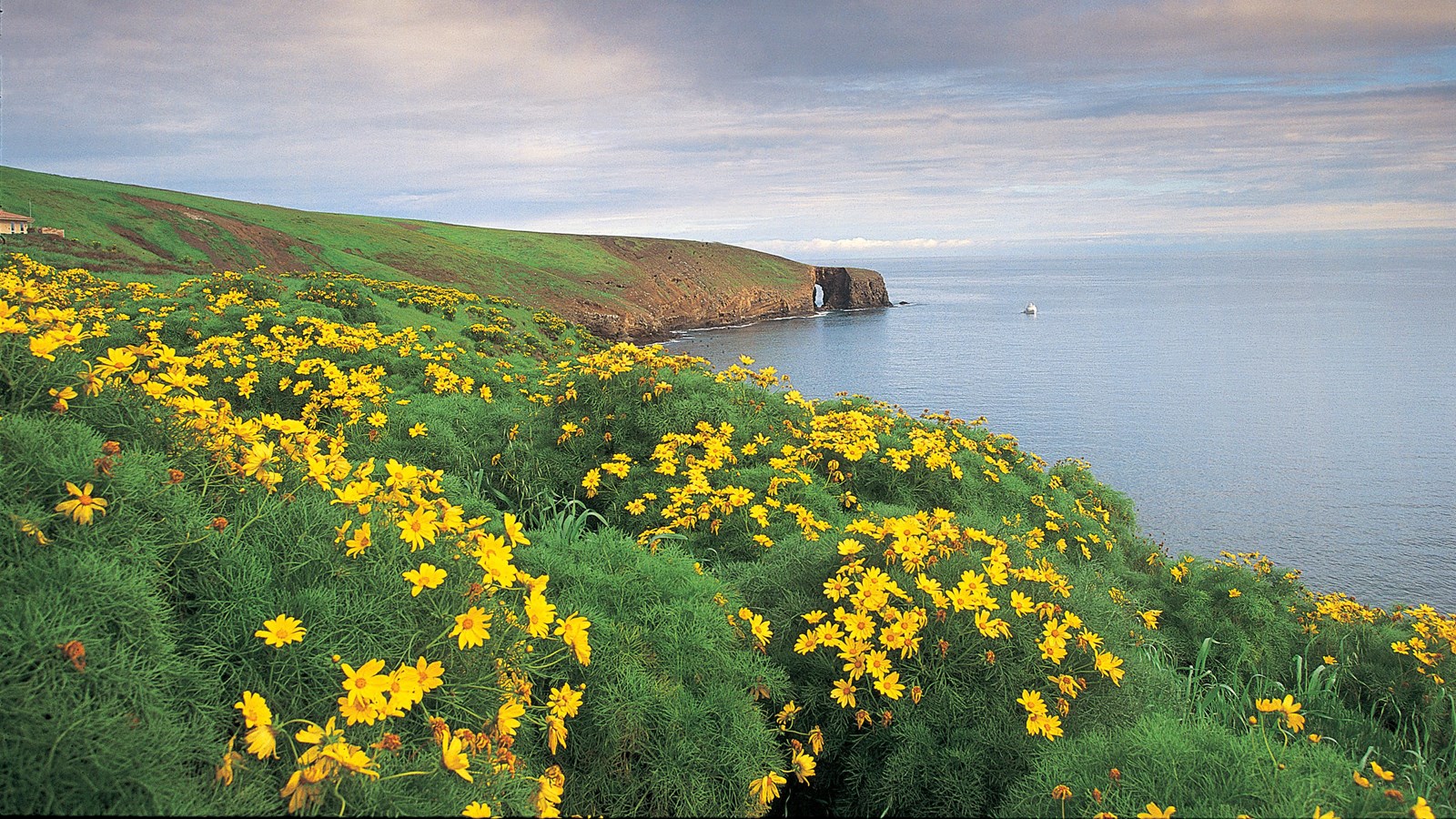
The smallest of the Channel Islands is deceptive. From a distance, this one-square-mile island may look a bit barren. Upon closer examination, the island offers more than one would expect-an island of resting elephant seals, blooming yellow flowers, tumbling Scripps's murrelet chicks, and rich cultural history. Santa Barbara Island is the center of a chain of jewels, a crossroads for people and animals.
Santa Barbara Island is 38 miles from the closest point on the mainland. The smallest of the California Channel Islands, it is only one square mile in size, or 639 acres. Formed by underwater volcanic activity, the island is roughly triangular in outline and emerges from the ocean as a giant, twin-peaked mesa with steep cliffs. In 1602 explorer Sebastian Vizcaino named the island in honor of the saint whose day is December 4th, the day he arrived.
Visitors can witness the incredible recovery of the island's plant life and wildlife after years of habitat and species loss due to ranching and farming activities, including the introduction of nonnative plants, rabbits, and cats. Although nonnative grasses still dominate the landscape, native vegetation is recovering slowly with the help of the National Park Service's restoration efforts. After winter rains, the native plants of the island come alive with color. The strange tree sunflower, or coreopsis, blossoms with bright yellow bouquets. Other plants, like the endemic Santa Barbara Island live-forever, shrubby buckwheat, chickory, and cream cups, add touches of color to the island's palette.
This recovery of native vegetation, along with the removal of nonnative predators, has aided in the reestablishment of nesting land birds. Today there are 14 landbirds that nest annually on the island. Three of these, the horned lark, orange-crowned warbler, and house finch, are endemic subspecies found only on Santa Barbara Island.
Unfortunately, the island's recovery did not come soon enough for the endemic Santa Barbara Island song sparrow. The destruction of this sparrow's sagebrush and coreopsis nesting habitat and the presence of feral cats led to the extinction of this species in the 1960s. This sparrow, which was found only on Santa Barbara Island and is now lost forever, was one of the smallest forms of song sparrow, differentiated by its very gray back.
Seabird colonies have also benefited from the recovery of Santa Barbara Island. The island is one of the most important seabird nesting sites within the Channel Islands, with 11 nesting species. Thousands of western gulls nest every year on the island, some right along the trailside. Fluffy chicks hatch in June and mature to fly away from the nest in July. The steep cliffs also provide nesting sites for the endangered California brown pelicans, three species of cormorants, three species of storm-petrels, and one of the world's largest colonies of Scripps's murrelets.
The rocky shores of Santa Barbara Island also provide resting and breeding areas for California sea lions, harbor seals, and northern elephant seals. These marine mammals feed in the rich kelp forests surrounding the island. The raucous barking of sea lions can be heard from most areas of the island. Overlooks, such as Sea Lion Rookery, Webster Point, and Elephant Seal Cove, provide excellent spots to look down on seals and sea lions. Visitors can also jump in the water to see what lies beneath the ocean surface. Snorkeling in the Landing Cove, visitors can see bright sea stars, spiny sea urchins, and brilliant orange Garibaldi fish. California sea lions and occasional harbor seals frequent the Landing Cove waters and the surrounding rocky ledges.
Island Facts
- Located in Santa Barbara County.
- Fifty-four miles from Ventura; 38 miles from the nearest mainland (San Pedro); 24 miles from Santa Catalina Island.
- Approximately 1.5 miles wide by one mile long; one square mile; 639 acres.
- Average rainfall-12 inches.
- Tallest peak-Signal Peak, 634 ft.
- Home to 14 endemic plant species and subspecies that occur only on the Channel Islands. Forms of buckwheat, dudleya, cream cups, and chicory are found only on Santa Barbara Island.
- The endemic, threatened island night lizard occurs only on Santa Barbara, San Nicolas, and San Clemente Islands.
- The island's cliffs offer perfect nesting habitat for one of the world's largest breeding colonies of Scripps's murrelets, rare seabirds.
- Absence of freshwater led the Tongva and Chumash to use the island on a seasonal basis and as a stopover between Santa Catalina and San Nicolas Islands.
Things To Do
One-day trips and overnight camping are options when visiting Santa Barbara Island. However, this island is more challenging to get to due to the limited transportation schedule. As with all the Channel Islands, visiting Santa Barbara Island is an exercise in preparation and self-reliance. Since there are no services on the islands, there are no remedies for poor planning once you have arrived.
Boat Transportation
Island Packers offers trips April through October. Travel time is about three hours. Landing is at the Landing Cove where visitors step from the boat onto a ladder to a small dock. From the dock, visitors must climb 200 feet along a ¼-mile trail to the top of the island. More...
Goods and Services
There are no goods, services, or accommodations (lodging) available on the island. Visitors must bring all their own food and supplies. Public phones are not available.
Water
There is no water available on the island. Visitors must bring all their water with them.
Picnicking
Picnic tables are available at the visitor center.
Visitor Center
A small visitor center is located on the island. Features include displays on the natural and cultural resources of the island.
Interpretive Programs
On days that the concessionaire boats run to the islands, guided hikes may be offered by national park volunteers or concessionaire naturalists. If they are not available to lead hikes, self-guided interpretive trail booklets are available. Hikes generally begin 30 minutes after the concession boats arrive on the island. A variety of guided hikes may also be offered during weekends that Island Packers drops off campers.
Hiking
Once visitors have scaled the rugged cliffs using the steep trail from the Landing Cove, they will find just over five miles of trails that meander over gentle slopes and low mountain tops to dramatic overlooks and magnificent coastal views. All hikers must stay on the trails for visitor safety and to protect fragile vegetation and nesting seabirds. No off- trail hiking is allowed. Portions of trails are subject to closure when pelicans are nesting from January through August.
Camping
Primitive camping is available (10 sites; $15 per night per site; reservations required). Picnic table, food storage box, and pit toilet are provided. No water is available. Distance from landing to campground is a quarter-mile and includes a 200-foot climb. Due to the boat schedule, minimum stay is generally three days.
Watersports
Santa Barbara Island is an ideal place for swimming, diving, snorkeling, and kayaking, but there are no lifeguards on the island. Since Santa Barbara Island is a cliff island, access to the water is only at the Landing Cove via a dock. There are no other accessible beaches unless you have a watercraft. Excellent watersports can be experienced at the Landing Cove. The underwater visibility is usually very good and the water is teeming with life. Kayaking north towards Arch Point or south towards the Sea Lion Rookery provides great wildlife viewing, sea caves, and arches. Experienced kayakers can circumnavigate the island's five-mile coastline.
Fishing
No fishing is allowed within the marine reserves located around the island. Fishing is allowed outside of these areas. To fish in Channel Islands National Park, possession of a valid California state fishing license with an ocean enhancement stamp is required and all California Department of Fish and Game regulations apply.
Wildlife/Wildflower Viewing
There is excellent wildlife viewing on Santa Barbara Island. A variety of seabirds can be seen throughout the year, including brown pelicans, cormorants, pigeon guillemots, and western gulls (gull nesting and chicks can be observed from the end of April through July). Seals and sea lions may also be viewed from Landing Cove and from the Sea Lion Rookery and Elephant Seal Cove overlooks. Santa Barbara Island is a great place to see the recovery of native vegetation with incredible wildflower displays. During a normal year of rainfall, wildflowers are best viewed in late winter and spring. The brilliant yellow coreopsis flowers usually peak between late January and March. In addition, some plants like gumplant, buckwheat, poppies, and verbena continue to bloom during the summer. Tidepools are not accessible from Santa Barbara Island. However, at a very low tide some intertidal plants and animals are visible from the dock or on the small shelf in front of the dock.
History and Culture Overview
The smallest of the Channel Islands, Santa Barbara Island is about thirty-eight miles from the mainland and is centrally located in relation to all eight of the offshore islands. Surrounded by sheer cliffs on all sides, the island sits alone in the sea with only little Sutil Islet and Shag Rock to the southwest and northeast respectively to keep it company. Few beaches are found on the island, and those that are prove to be rocky and often treacherous to reach. The island has a pastoral quality with rolling slopes and a wide saddle between twin peaks, the taller of the two reaching 634 feet. Santa Barbara Island is home to native seabird colonies, barking sea lions, and a rich cultural history.
Native Occupation and European Contact
Due to the lack of fresh water and few terrestrial resources, Santa Barbara Island most likely did not support any permanent native settlements. Recent studies show evidence that occupation of the island dates back at least 4,000 years, suggesting seasonal visits to the island. Southern California Indians would have been drawn to the island by the rich marine life surrounding the rocky shores, being able to fish, harvest shellfish and hunt pinnipeds, as well as manufacture tools.
Since early European explorers did not leave any indication of landing on the island, no information about native island use or occupancy of the island has come from those sources. Although the explorers did see the small island, it did not receive much documentation. Cabrillo's chroniclers dubbed the southern islands, which included Santa Barbara, the "other islands of San Lucas." Sebastian Vizcaino gave the island its name in honor of the saint whose day was December 4, the day he arrived, in 1602.
Early History
Santa Barbara Island came into the possession of the United States in 1848 and has continued in U.S. government ownership since that time. Early government surveys done in 1853 and 1871 provided a topographic map of the island and Signal Peak was given its name when a triangulation signal was used at its highest point. While no leases were recorded on the island prior to 1909, people did periodically occupy the island. In The Land of Sunshine, published in 1897, author J. R. Britton compared the island's profile to that of a camel; he wrote that "upon the higher hump stands the decaying beacon of the U. S. Coast Survey." He also noted "a narrow shelf where a crayfisherman has built a hut of lath and canvas."
Fisherman and hunter Heman Bay Webster lived on Santa Barbara Island as a squatter in the 1890s. He built a cabin in 1896 near the arch on the island's northwest point that now bears his name, Webster Point. In a 1940 interview, he recalled "abundant" cats living on the island until disease diminished their numbers. Webster was at home with the elements, going barefoot and having interests in other islands, mainly Anacapa where he ran sheep. Other men made Santa Barbara Island a regular port around the turn of the century as well. Buster Hyder recalled that Carl Jergensen and Bert Johnson spent years fishing for lobsters at Gull Rock (Sutil Island) in Thor, a boat built by Hyder's father.
The U.S. Department of Commerce and Labor began leasing the island for agricultural and recreation purposes in 1900, advertising the island for a five-year lease in newspapers along the coast. J.G. Howland, being the highest bidder, obtained the first recorded lease of Santa Barbara Island on July 6, 1909. Soon after, Howland sublet the island to C.B. Linton for the purpose of propagating pearls in abalone. After five years, Howland did not renew his lease on the island.
The Hyder Family
In the spring of 1914, public notices were again posted for a five year lease of Santa Barbara Island. Two bids were received, T.D. Webster of Carpinteria and Alvin Hyder of San Pedro; Hyder made the higher bid of $250 a year and acquired the lease on June 16, 1914. The largest settlement of people on the island in historic times moved onto the island with Hyder. At one time around 1915, about fifteen people lived on the little island including Alvin's wife Nora and son Denton O., "Buster", as well as his two brothers and their wives.
The year prior to the families' arrival, Hyder and his brothers had built a house near the edge of the island 100 yards south of and 150 feet above the landing. They anchored the house to the ground by cables so the wind would not blow it off the cliff. Hyder rebuilt the pier at the landing, where supplies and equipment were unloaded with a boom. To provide relief from carrying goods up and down 150 feet, he rigged a sled on wood tracks down the steep slope between the landing and the house.
Since the island had no springs or flowing water, the Hyders constructed a system of reservoirs. They built two large concrete cisterns at the house and brought water on Nora II from the mainland. In 1918 they installed a Rambler auto engine to pump the water to the house from the landing. They searched the island for water sources, even looking for fresh water deep in sea caves, with no luck. Any collecting methods possible were used, no matter how disgusting. Buster recalled how "you had to limit your drinking water. It had to last a year. Then it got stagnant. Many times when it was raining I'd drink water out of horse tracks. No kiddin'." Buster had the job of removing dead mice from the drinking water supply every day. "Boy, it was hard to drink it. But when you don't have anything else, you have to drink it."
In the early decades of the century, people made good money raising rabbits, marketing the meat and selling the pelts. Following the trend, the Hyders brought hundreds of pure black and pure white Belgian hares out to the island and turned them loose. They also brought about 300 sheep to the island in 1915, the first known sheep to graze there, where they would be fattened and sold for meat. The Hyders also had two horses, Dan and Charlie, and two mules, Jack and Beck, which they kept in a barn they built. Along with these animals, the Hyders also kept goats, pigs, chickens, turkeys and geese on the island.
The Hyder lease expired in 1919 but they stayed on anyway. After seven years of hard work and frustration, they decided to leave the island in 1922. They took their twelve goats, 300 sheep, dogs and four horses to their homestead in Cuyama Valley north of Santa Barbara. Following the terms of the lease, they tore down the buildings and brought the materials to the mainland, although they failed to remove the main house. Reportedly Alvin Hyder tried to lease Santa Barbara Island for another term without success; an entrepreneur from Venice outbid him. Nevertheless, he took 250 sheep back to the island for fattening many years after their lease had run out.
Government Activities on Santa Barbara Island
After the Hyders left the island, several attempts to lease and build resorts were made, but none succeeded. No major improvements were made to the island until the government built lighthouses. As early as 1853 government officers made note of the potential of Santa Barbara Island for lighthouse purposes. However, it would take 75 years to get a navigational aid built on Santa Barbara Island. On July 27, 1928, the Bureau of Lighthouses authorized an automatic light on the northerly point of the island "for the protection of inter-island navigation in general and particularly for the protection of the Hawaiian Island and trans-Pacific traffic, which follows a course passing six miles to the northward of the island." In 1934, a second light tower went up on the south end of the island, on the westerly side, located 486 feet above the water and visible for twelve miles. When Santa Barbara Island became part of the Channel Islands National Monument in 1938, two parcels of land and right of entry were retained for by the government for lighthouse purposes.
In April 1936, the Commandant of the 11th Naval District requested permission to install and maintain a range finder marker on Santa Barbara Island. The Navy built a tower about ninety feet tall at the highest point on the island, 634-foot Signal Peak, which was probably removed by 1942 when the Army Signal Corps installed radar on the island. At the outbreak of World War II, the military ordered both lights to be temporarily extinguished. They were relit in 1943 when the immediate threat to Los Angeles Harbor was felt to be over. During the war, the Navy took over responsibility for U. S. Coast Guard activities, including aids to navigation, and instituted a program of timed blackouts of coastal lights in case of enemy attack. The Navy also set up Coastal Lookout Stations on the island to help prevent attacks on the mainland.
Santa Barbara Island and Channel Islands National Monument
As early as 1932, the Bureau of Lighthouses suggested transferring Santa Barbara Island, as well as Anacapa Island, to the National Park Service for preservation. Not until 1938 did the National Park Service respond, and on April 26, the island became part of the newly designated Channel Islands National Monument, encompassing Anacapa and Santa Barbara islands. On June 28, 1939 NPS biologists E. Lowell Sumner, Jr. and R. M. Bond submitted a report on the biology of the islands suggesting protection of the island by the Coast Guard and State Division of Fish and Game, as well as posting signs in order to alert visitors of the island's new Monument status.
In 1949 the monument boundaries were expanded to include "the area within one (1) nautical mile of the shoreline of Anacapa and Santa Barbara Islands." On Santa Barbara Island, this meant that the rocky beaches, offshore rocks and Sutil Island and Shag Rock would be protected. The Channel Islands National Monument was moved from the supervision by Sequoia National Park to be overseen by Cabrillo National Monument in San Diego in 1957. Rabbits and vandalism became major problems on the isolated island, but by the time it became part of the Channel Islands National Park in 1980, the rabbits were gone and vandalism was declining.
To help develop the island for visitor use, the National Park Service constructed a new dock and ranger residence on the island in 1991. Extensive habitat restoration efforts have been underway on Santa Barbara Island to increase the native plant and bird populations which were destroyed after years of rabbit and sheep grazing. Today, visitors can camp, hike trails covering the whole island, snorkel and kayak to see the beautiful natural environment this small, remote island has to offer.
Ethnographic Island Place Names
Ethnographic island place names aid in native language revitalization, illustrate cultural values, and provide tangible connections to cultural landscapes and seascapes.
Many of these place names were recorded by ethnographers and anthropologists in the late 1800 and early 1900s. J.P. Harrington was an ethnographer who worked for the Smithsonian Institution in Washington, D.C., from 1915 to 1955. He interviewed American Indian consultants, including Chumash and Gabrielino Tribal members, and recorded information about native languages and culture.
Chumash Indians Fernando Librado (Kitsepawit) and Juan Estevan Pico were the main sources for island place names. They were both born and raised in Ventura. They learned of the island places from Chumash elders, most notably Ursula (of wima) and Martina (of limuw.) Pico's interviews of Martina resulted in a list of island place names given in order from east to west (or vice/versa,) to anthropologist, H.W. Henshaw. Anthropologists have cross-referenced Pico's list with the archeological record, baptismals, and marriage patterns.
Twenty-six new place names were recently identified and mapped by Matthew Vestuto (Barbareño/Ventureño Band of Mission Indians; Advocates for Indigenous California Language Survival) with assistance from Kristin Hoppa (Archeologist, Channel Islands National Park) and the Chumash community. These names reference island peaks, water, landforms, islets, trails, caves, and beaches.
Please note that lowercase is used because capitalization is a convention in English which poses problems in the writing of native languages.