Last updated: May 27, 2021
Place
Visitor Contact and Ranger Station and National Park Service History
Quick Facts
Amenities
2 listed
First Aid/Medical Care Available, Information
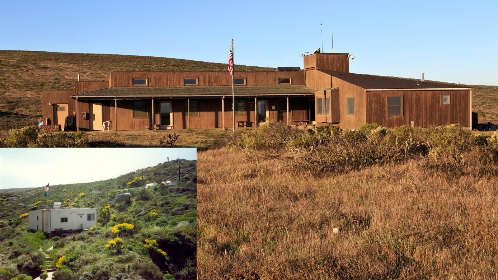
The National Park Service (NPS) constructed a ranger and visitor contact station in a design intended to be reminiscent of the Lester ranch house. The building, located at the west end of the landing strip, features an apartment for the island ranger, an office/ranger station, and a bunkhouse for visiting researchers. The building is powered by solar energy and receives water from a modern well in Nidever Canyon. The airstrip's west end conveniently abuts the entrance to the ranger station.
Although the Navy retains legal possession of the island and may in perpetuity, agreements were made in 1976 that allowed the National Park Service to manage the island.
NPS and Navy Cooperation
The idea of including San Miguel Island in the Channel Islands National Monument had circulated for decades. Activities in this direction increased in the early 1960s as President Kennedy pressed for parklands and NPS historian Ross Holland produced a history of the island in 1961.
The Navy, however, continued to deny transfer of San Miguel to the NPS. It needed the island to test guided weapons systems, for fleet squadron practice, and for on-land instrumentation. Creation of a park would have an adverse effect on the required readiness training of fleet aviation units. A park would attract the general public into the nearby hazard area, which had to be kept free to assure maximum range scheduling. In short, the position of the Commander, Pacific Missile Range was that there was no objection to the proposed park provided San Miguel Island was excluded until it was no longer desired for Navy purposes. The Navy also wanted unrestricted access to and use of existing improvements on privately owned Santa Rosa Island and Santa Cruz Island.
In 1948 biologist Lowell Sumner had made an air inspection of the northern Channel Islands after which he recommended nominal transfer of San Miguel Island from Navy to NPS. If that could not be done, he urged that the Navy should stop the destructive sheep grazing.
In July of 1957 Sumner conferred with regional specialists on seashore survey at the subject island and then wrote the Regional Director that he was still of the same opinion he had in 1939: the scientific features of San Miguel Island were so outstanding that it warranted every effort of preservation. It was approximately 14 times as large as Santa Barbara Island and had a correspondingly greater wealth of unique biological features. He noted that the federal government had, through its continuance of sheep grazing, permitted destruction on San Miguel; thus it should be up to the government to restore the land.
A few days later the Regional Director wrote to the Director of NPS in Washington asking that San Miguel Island be added to Channel Islands National Monument. He wrote that no NPS representative concerned with biological and other natural resources had been on the island since 1939. The only activity on the island or around it in 1957 was commercial and military.
The Navy could not give up San Miguel, yet preservation experience lay with the National Park Service. During 1962 the Western Regional Office, NPS, and the Navy drew up a series of interim agreements and put forth plans for the future management of San Miguel Island. NPS pointed out that they had been criticized for the lack of protection they offered on the islands they already controlled, but that lack of funds, transport, and personnel was the reason.
The Navy was concerned about a need for launching missiles and the need to close down the island temporarily to continue the launches. The Navy discussed using San Miguel and San Nicolas for a naval petroleum reserve, and this was fought by local conservation groups who urged national monument status for San Miguel instead. Letters went to President Kennedy urging his support for conservation.
Recognizing that San Miguel and Prince Islands contained rich and unique natural and cultural resources, the Department of the Navy and Department of the Interior entered a Memorandum of Agreement on May 7, 1963 for "protection of natural values and historic and scientific objects" on the two islands. The agreement authorized the Department of the Interior to take action regarding resources inventory and protection. Interior agreed to evaluate natural and cultural resources, to promote recovery or reintroduction of rare and locally extinct plants and animals, and to cooperate with the Navy in its rules and management of the islands. It was understood that the Navy had paramount use of the islands as a missile test range and that in the future it could even be a Naval Petroleum Reserve. Both parties recognized the priority of military uses. As a result, both departments would share responsibility for preservation and management. San Miguel and Prince Islands would not be open for public recreational purposes, and the Navy owned the island. These facts made it unlawful for the NPS to spend its funds there.
NPS personnel began to study the island after the agreement was signed. Historian Daniel Bienvenu of the National Park Service prepared a Historic Structures Report for the Lester ranch house in November of 1965. Bienvenu found the old house abandoned for almost 20 years and quite dilapidated. He noted that while many fixtures had been taken away, numerous artifacts had been left, such as a table, beds, and sinks and toilets. Bienvenu recommended that the house, "a hand-made oddity, with no recognizable architecture," be retained on the site "until destroyed by the elements." Two years later, the ranch house burned to the ground along with the outbuildings and shearing shed.
In cooperation with the Navy, the National Park Service produced a management plan for the island in the late 1960s. The document's authors recommended a wide range of activities on the island, concluding, "San Miguel and Prince Islands possess both unique and irreplaceable scientific and natural values." Included in the recommendations were exotic plant identification and removal, enhancement of native plants, removal of feral burros, and studies of fire ecology, marine mammals population and ecology, faunal species, seabird and landbird ecology, underwater features, and history, prehistory and archeology.
Two major agreements were negotiated and signed in regard to San Miguel Island after Park Superintendent Bill Ehorn took office in 1974. The first, signed in 1976 was an amendment to the agreement between the Department of the Interior and the Department of the Navy that related to protection of natural values on San Miguel. The amendment further recognized that the National Park Service could expend appropriated funds on the island to enforce NPS regulations and to develop a tightly controlled visitor program. Public access was to be confined to daylight hours and importantly tied to spending of funds at the island.
As a result of this, a tent was set up in Nidever Canyon adjacent to the old windmill to serve as temporary Park headquarters; beginning in 1978 visitors could contact the ranger as they walked up the canyon to the island. Ehorn assigned Mike Hill as ranger at the post. Hill accompanied all visitors to the island who wanted to take the trail that follows the road bulldozed during World War II.
Ehorn convened an advisory group that included A. Starker Leopold, Carey Stanton, Ralph Philbrick and Bob DeLong. In 1977, a Statement for Management was drawn up for San Miguel and Prince Islands by the National Park Service as well as an agreement between the National Marine Fisheries Service and the National Park Service for management and protection of the pinnipeds on San Miguel Island.
A decision by the United States Supreme Court gave the State of California control over tidal lands, not the National Park Service, although designation of Channel Islands National Marine Sanctuary in 1980 offered federal protection of those waters. On land, meanwhile, Monument staff in 1977 killed the last of the feral burros that had been roaming the island for decades, finally bringing to a close the era of domestic livestock grazing on San Miguel Island.
After creation of Channel Islands National Park in 1980 the National Park Service took on additional management of San Miguel and Prince Islands, although the Navy retained ownership until a transfer would be authorized by the Navy. A General Management Plan (GMP) was quickly adopted that spelled out development and protection of the island. The GMP designated the entire island as a historic zone overlapping the natural zone, which extended into the waters surrounding the island.
Of the natural zone, 2,800 acres would be a protected area in which development and visitor access would be restricted. Only one acre, in two half-acre parcels, would be used for developments: the NMFS research station at Point Bennett and a proposed visitor contact station at the Lester Ranch site. Camping would be prohibited and visitors were restricted to day use only and by permit.
The NPS adopted amendments to the 1980 GMP in 1984, which included minor changes in plans for San Miguel Island. Noting the dearth of visitors due to extreme conditions, park-imposed restrictions and distances from the mainland, the GMP proposed one or two small primitive campgrounds, one at the Lester Ranch site and another at the dry lake bed (the latter location was dropped within a year). The plan also extended the range of ranger-led walks, although it still limited trail construction. In light of these potential developments, the development zone was increased to 1.5 acres.
A small amount of development occurred in the 1980s. The tent in the canyon was replaced by a conex box. NPS crews eventually constructed a campground in a former sheep corral near the Lester ranch house ruins. Trail development remained low-key in the interest of habitat restoration, with visitors being restricted to ranger-led walks if venturing beyond the area of Nidever Canyon and the old ranch site. The trail to Point Bennett was used for such walks and by staff and volunteers of the field station. A trail to Lester and Harris points was developed but like the Point Bennett trail, was restricted to supervised hikes.
Park resources staff focused on archeological and shipwreck survey work as well as island fox monitoring, pinniped research and habitat restoration. In 1997 the NPS constructed a modern building up on the mesa to replace the temporary ranger station in the canyon. Designed to echo the lines of the Lester ranch house, the one-story structure combined a ranger contact station, ranger residence and bunkhouse for visiting researchers. The building is powered by solar energy and receives water from a modern well in Nidever Canyon. The airstrip's west end conveniently abuts the entrance to the ranger station.