Last updated: September 19, 2025
Place
Wayside: Of Wrecks and Water Trails

NPS credit
Historical/Interpretive Information/Exhibits
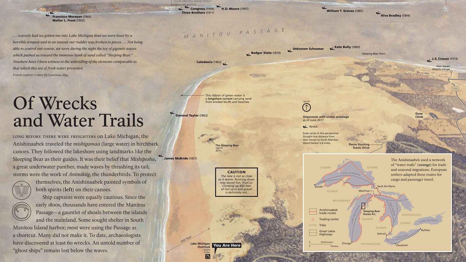
Long before there were freighters on Lake Michigan, the Anishinaabek traveled the mishigamaa (large water) in birchbark canoes. They followed the lakeshore using landmarks like the Mother Bear as their guides. It was their belief that Mishipeshu, a great underwater panther, made waves by thrashing its tail. Storms were the work of Animikiig, the thunderbirds. To protect themselves, the Anishinaabek painted symbols of both spirits (left) on their canoes.
Ship captains were equally cautious. Since the early 1800s, thousands have entered the Manitou Passage-a gauntlet of shoals between the islands and the mainland. Some sought shelter in South Manitou Island Harbor; most were taking a shortcut along the shore. Many did not make it. To date, archaeologists have discovered at least 60 wrecks. An untold number of "ghost ships" remain lost below the waves.
...scarcely had we gotten out into Lake Michigan than we were beset by a horrible tempest and in an instant our rudder was broken to pieces ... Not being able to control our course, we were during the night the toy of gigantic waves which pushed us toward the immense bank of sand called "Sleeping Bear." ... Nowhere have I been witness to the unbridling of the elements comparable to that which this sea of fresh water presented.
-French explorer Comte De Castelnau, 1839
This ribbon of bright green water is a longshore current carrying sand from eroded bluffs and beaches.
CAUTION: The lake is not as close at it seems. Climbing down may sound fun, but trust us, climbing up 40 stories-or two Statues of Liberty-of hot sand and gravel is not.
In 1903, the steamer Walter L. Frost sunk off South Manitou. Nearly sixty years later, the Francisco Morazon ran aground atop thewreck of the Frost. It's still visible today.
Caption:
Shipwrecks with visible wreckage as of June 2016 Scale varies in this perspective
The Great Lakes Highways
The Anishinaabe used a network of water trails (orange) for trade and seasonal migrations. European settlers adapted these routes for cargo and passenger travel.
