Last updated: April 4, 2021
Place
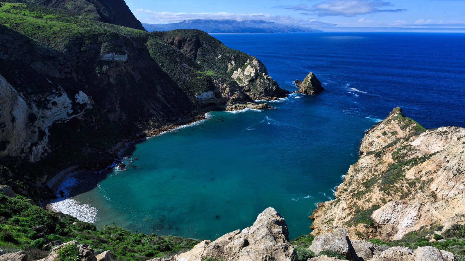
Potato Harbor Overlook
Tim Hauf, timhaufphotography.com
Quick Facts
Amenities
1 listed
Scenic View/Photo Spot
There is no beach access to Potato Harbor. The cliffs surrounding the harbor are steep and dangerous.
Once you have reached the overlook at Potato Harbor you can probably guess as to how this harbor received its name-its oval shape resembles that of a potato. From the overlook you also have a magnificent view to the west and the rest of Santa Cruz Island. Santa Cruz Island is the largest island off the west coast of the U.S. At 96 square miles, around 62,000 acres, it is about four-times the size of Manhattan. Over 75 percent of the island is owned by The Nature Conservancy, a private, non-profit organization, with similar goals as the National Park Service-the preservation of the islands' natural resources. The National Park Service and The Nature Conservancy work together to ensure the protection of these island resources.
Diatomaceous Earth
As you followed the road to Potato Harbor, you probably noticed areas of bright white sedimentary rock that have been exposed on the hillsides due to erosion. This is the same rock type that is evident along the Cavern Point trail. It is known as diatomaceous earth. It is derived from very small single-cell sea plants called diatoms, which are made of silica (silicon dioxide). As these plants die, their silica skeletons settle down to the various marine sediments at the bottom of the ocean, often enmasse. Diatomaceous earth is mined throughout the world for use in filters, such as pool filters, and as an insecticide.
The Giant Kelp Forest
From this vantage point, one also has the opportunity to gaze upon another part of the park-the marine environment. One nautical mile of water around each island in the park is part of Channel Islands National Park (six nautical miles around each island is part of Channel Islands National Marine Sanctuary).
Within this ocean realm below one may be able to see or hear California sea lions. These playful animals are often spotted just to the west of Potato Harbor, hauled-out on the rocks. Sea lions, along with a variety of other marine species, depend upon the extensive kelp forests that can be found around Santa Cruz Island and the other Channel Islands. While urban and industrial development has altered much of the southern California coastal mainland, the islands contain the most undisturbed stretches of coastline in this region, providing some of the best conditions for kelp forests and their inhabitants.
Kelp is a type of algae that, under ideal conditions (cold, nutrient-rich water), is one of the fastest growing plants on earth-it can grow 2 feet per day. This foliage provides food, shelter, and protection for over 800 different species-from foraging nudibranchs, to grazing snails, to fish seeking refuge, to whales seeking a plankton snack.
But we must not forget about ourselves. Not only do we feed upon some of the animals that depend upon the kelp forest, but those of us who eat ice cream, salad dressing, and even use tooth-paste are also using a little bit of kelp as well. Kelp is harvested for a natural ingredientcalled algin, which is used as a suspending, stabilizing, emulsifying, gel-producing, and film-forming additive in more than 70 commercial products. In addition, marine plants such as kelp provide the earth with 80 percent of its oxygen.
Despite these benefits, the kelp forest and its inhabitants are in jeopardy. Pollution and over-harvesting of marine species have completely altered the kelp forest ecosystem. Kelp forests in southern California today cover less than half the area they covered at the turn of the century.
Marine Protected Areas
However, with the establishment of Marine Protected Areas (MPAs), improved pollution controls and fishing regulations, transplantation of kelp, public education, and various research programs some of these problems have been corrected.
Within the park and sanctuary a network of MPAs provide a refuge for sea life and opportunities for recreation, education, and science. In 11 Marine Reserves (including the Scorpion Marine Reserve in the waters below you from Potato Harbor to Scorpion Rock), recreational fishing and commercial harvest are prohibited; limited fishing and harvest are allowed in two Marine Conservation Areas. The MPAs total 318 square miles, the largest such network off the continental United States and part of a larger effort throughout the world to conserve natural, historic, and cultural marine resources.