Last updated: April 4, 2021
Place
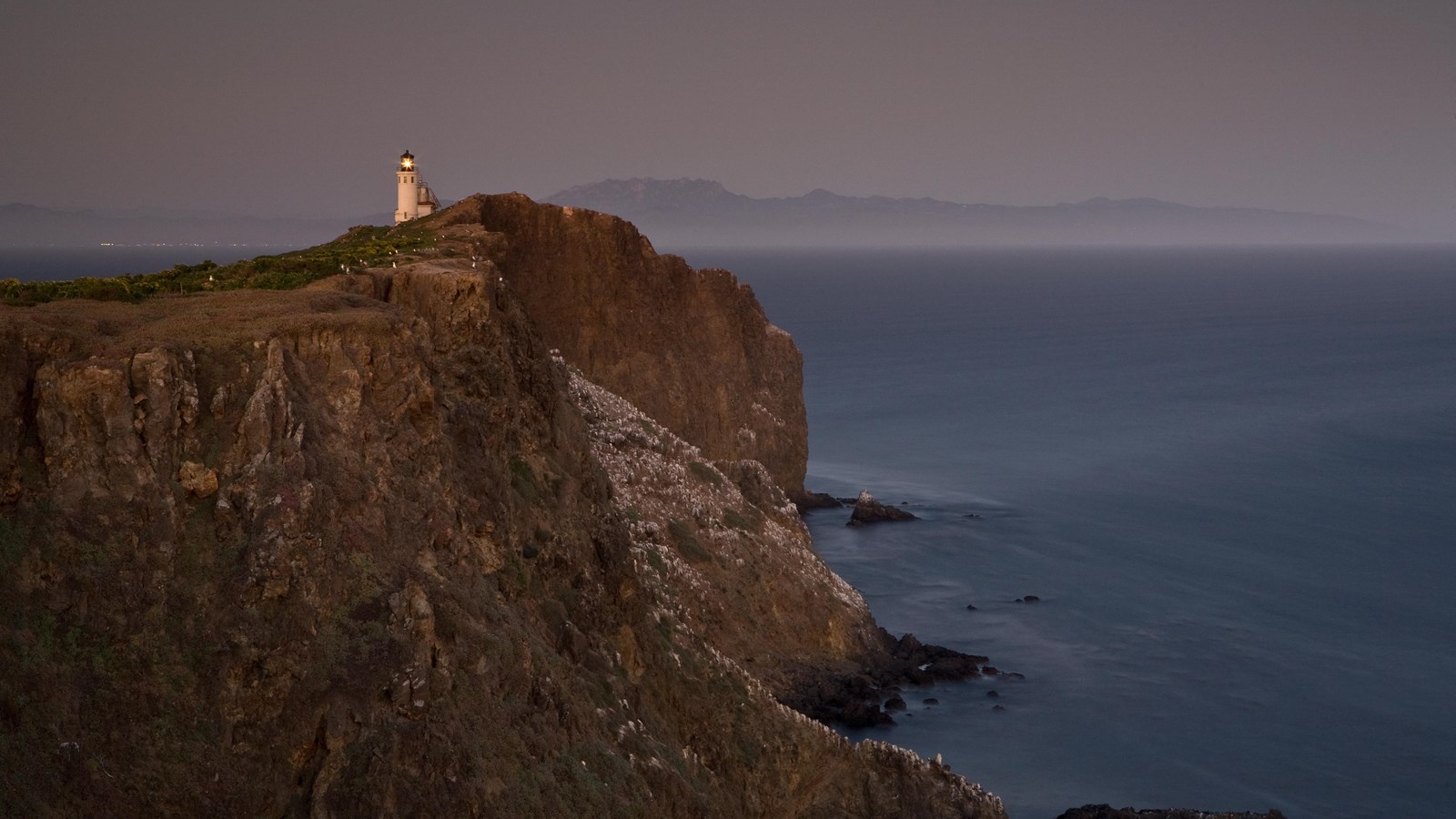
Pinniped Point
Tim Hauf, timhaufphotography.com
Quick Facts
Amenities
1 listed
Scenic View/Photo Spot
The .4-mile, round trip hike from the visitor center leads a an overlook with views of the south coast, the historic light house, and sea lions hauled out and sunning themselves on the narrow, rocky shoreline below.
The isolated beaches scattered along Anacapa's northern and southern shores offer harbor seals and sea lions an ideal combination of safety from predators and freedom from human disturbance.
Even Anacapa's isolation could not protect these and other sea mammals from human predation. Fur hunters exploited the large communities of sea otters near the Channel Islands. Fur seals, elephant seals, and sea lions were also killed for their fur, hides, and oil. Even sea lion whiskers were a popular commodity. Gentlemen used them for pipe cleaners.
Sea mammal hunting ended in the early 1900s and laws now protect these marine species. Today harbor seals and sea lions regularly breed on Anacapa's rocky beaches. Their protected populations are nearly recovered from centuries of slaughter.
An Ocean Park and Sanctuary
From this incredible overlook, one has the opportunity to gaze upon another part of the park-the marine environment. One nautical mile of water around each island in the park is part of Channel Islands National Park, and six nautical miles around each island form Channel Islands National Marine Sanctuary.
The Channel Islands lie within a large embayment known as the Southern California Bight-an area just below Point Conception where the California coastline turns sharply to the east. Within this area, the seafloor is composed of canyons, banks, escarpments, sea mounts, and deep basins (the Santa Cruz Basin is deeper than the Grand Canyon). Nutrient-rich waters upwelling from these depths mix and mingle with cool waters from the north (California Current) and warm southern waters (California Countercurrent), creating the Santa Barbara Gyre-a swirling eddy that circulates nutrients and supports a wealth of marine plants and animals, from giant kelp forests and blue whales to tiny crabs and plankton. Here, northern and southern species overlap, creating a transition zone between the Oregonian and Californian marine biogeographic provinces.
Kelp Forests
The isolated islands contain the most undisturbed stretches of coastline in southern California, providing some of the best conditions for kelp forests and their inhabitants.
Kelp is a type of alga that, under ideal conditions (cold, nutrient-rich water), is one of the fastest growing organisms on Earth-it can grow two feet per day. This foliage provides food, shelter, and protection for over 800 different species-from foraging nudibranchs, to grazing snails, to fish seeking refuge, to whales feasting on plankton.
But we must not forget about ourselves. Not only do we feed upon some of the animals that depend upon the kelp forest, but also those of us who eat ice cream, salad dressing, and even use toothpaste are all using a little bit of seaweed as well. Kelp is harvested for a natural ingredient called algin, which is used as a suspending, stabilizing, emulsifying, gel-producing, and film-forming additive in more than 70 commercial products. In addition, marine algae and plants such as kelp provide Earth with 80 percent of its oxygen.
Despite these benefits, the kelp forest and its inhabitants are in jeopardy. Pollution and over-harvesting of marine species have altered the kelp forest ecosystem. Kelp forests in southern California today cover less than half the area they covered at the turn of the 20th century.
However, with the establishment of marine protected areas (MPAs), improved pollution controls, fishing regulations, research, and public education, some of these problems have been corrected.
Marine Protected Areas
Within the park and sanctuary a network of MPAs provides a refuge for sea life and opportunities for recreation, education, and science. In 11 marine reserves (including two on Santa Rosa Island-around Carrington and Skunk Points), recreational fishing and commercial harvesting are prohibited; limited fishing and harvesting are allowed in two marine conservation areas. The MPAs total 318 square miles, the largest such network off the continental United States and part of a larger effort throughout the world to conserve natural, historic, and cultural marine resources.