Last updated: October 10, 2024
Place
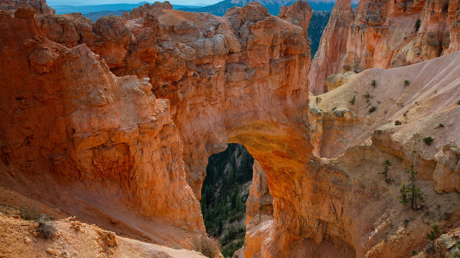
Natural Bridge
NPS Photo / Peter Densmore
Quick Facts
Location:
Mile 12.25 of the 18 mile Southern Scenic Drive
Significance:
One of 9 viewpoints along the Southern Scenic Drive
Amenities
1 listed
Wheelchair Accessible
Like some other features in the park, Natural Bridge is not what its name would suggest. Natural bridges are formed by the movement of a stream or river cutting through rock. The impressive feature seen here is instead a natural arch, or window, formed primarily by the expansion of ice in cracks deep within. A more weathering-resistant layer of rock protects the softer rocks below from more rapid erosion, while ice, rain, and wind slowly open the arch wider and wider.
As the edge of the plateau has eroded back, a small gully has formed that flows with rain and melting snow (now more than 125 feet below the arch). Undoubtedly some day the top of the arch will collapse, leaving behind new hoodoos on either side.
Trails
No trails depart from this area.
Landscape Features
To the North
View the eroded and forested edge of the Paunsagunt Plateau, carved by rain and melting snow into bowl-shaped amphitheaters.
To the East
Here the iron-oxide colored limey mudstones of the Pink Cliffs of Bryce Canyon are being weathered and eroded by rain and melting snow to form a bowl-shaped amphitheater separated from amphitheaters to the north and south. Within this amphitheater, Natural Bridge is being formed by the same process as all hoodoos: walls or fins are formed by the presence of harder, more erosion resistant cap layers as the plateau rim erodes backwards through the action of rain and melting snow. Windows then form as rain and melting snow trickle into cracks within these fins. Overnight freezing temperatures cause this water to expand as it turns to ice, breaking the rock apart from within and creating windows--of which Natural Bridge is a very large example. Eventually, the caprock will collapse, leaving behind rock spires on either side of the window known as "hoodoos".
To the West
The rolling ponderosa forest of the Paunsaugunt plateau is deeply incised here by water travelling north to the Tropic Reservoir. The direction of flow is decided by the plateau's upward tilt to the south and has created a rain divide between the Great Basin of Nevada and the Colorado River that follows the edge of this plateau.
To the South
View the eroded and forested edge of the Paunsagunt Plateau, carved by rain and melting snow into bowl-shaped amphitheaters.