Last updated: March 28, 2021
Place
Military on San Miguel
Quick Facts
Amenities
1 listed
Historical/Interpretive Information/Exhibits
Nearby the Lester ranch site lies the scant remain of the two-room Navy barracks building that was constructed as part of the Lookout Station on San Miguel during World War II.
The United States' military forces saw potential defensive capabilities in San Miguel Island in the 1930s that led to its exclusive use as a U. S. Navy training zone. The island was used for a short time as a radio communications outpost during the 1930s, as a coastal lookout post during World War II, a bombing range and, most significantly, as a key training and testing area for the Navy's Pacific Missile Range, a key component in the nation's Cold War defense system. The military uses of San Miguel Island resulted in an unmeasured amount of resource damage, ranging from road building to the effects of bombing and target practice. Today, the Navy retains legal possession of the island and may in perpetuity.
U. S. Marines Temporary Radio Outpost, 1933
Tensions in the Pacific led the U. S. Marines to establish a radio outpost on San Miguel Island in 1933. The post would mount a continuous watch for the enemy and maintain radio communications with the commander of the base force. Authorities assigned the San Miguel Island outpost to the battleship Tennessee in Los Angeles harbor. One of the men, Wallace M. Greene, recounted his experiences on the island in the Marine Corps Gazette more than 50 years later, on which this account is based.
On February 6, 1933 eight Marines and two "blue jackets" (civilians) under command of a second lieutenant boarded the tug Algorma for the night trip to San Miguel Island. The men off loaded into a whale boat at Tyler's Bight and unloaded their gear on the beach: "tents, heavy radio parts, food, bedding, firewood and 60 tons of fresh water had to be passed by hand up a 40-foot sand bank to the top of the bluff and from there packed up the hill to the camp," recalled Greene. They constructed a camp site "on a well-drained grassy slope in the lee of a steep ridge about 300 yards from the beach," over a mile from the site of the radio station to be erected on the western point. After digging a latrine trench and a garbage hold, and setting up a field range composed of a three-foot-square boiler plate with a fire pit beneath, the men christened their new home on San Miguel Island, "Camp Tyler."
Having settled in, the men then packed the radio equipment to the site at Point Bennett. Consisting of a Navy field radio set including transmitting and receiving units, the radio station also required a gasoline motor, generator, hand generator, calibrator, antenna poles, spare parts, gasoline, oil, water, two tents and other equipment. It took ten hours to set up the station and contact the base ship some 100 miles away. The men christened the radio outpost "Camp Hardpan" in honor of the frustrating conditions encountered while driving stakes for the antenna and tents.
The camp commander put two sentries on 24-hour watch, requiring five watches of one eight-hour and four four-hour stints. The radioman on watch listened to an assigned frequency for 15 minutes each hour. In off-hours the men explored the island and collected abalone.
The men put up with blowing sand which covered their camp fires (one sandstorm lasted three days), and wind that threatened the tents which had been double-guyed and staked: "their sides bulged like sails, but they held." Sand continually clogged the carburetor of the gasoline engine, which required cleaning "at all times."
The Marine outpost on San Miguel Island was short-lived. An emergency-reportedly an enemy aircraft carrier spotted in the Santa Barbara Channel, later considered to be a phantom or spurious sighting-caused a rapid abandonment of the camp on February 18, when the men were picked up by the Tennessee. Camp Hardpan existed for less than two weeks.
Transfer to U. S. Navy Administration
President Roosevelt transferred the control and jurisdiction of San Miguel Island and Prince Island from the Secretary of Commerce to the Secretary of the Navy for naval purposes on November 7, 1934. The Order reserved for use by Commerce sites to be selected for aids to navigation and for incidental facilities.
On January 5, 1939, Newton B. Drury, Director, National Park Service, Washington, requested a study of San Miguel. The resultant report summarized the overgrazing in these words: ". . . The present number of sheep (1,100) would undoubtedly represent a conservative stocking under normal conditions, nature now is forcing man to pay the penalty for gross malpractice committed many years ago. For this reason, 1,100 sheep now are destructive of the remnant of the island's resources, although originally such a number might have been pastured there indefinitely with little or no harm."
As a result of the report, recommendations to transfer the island to the National Park Service and stop the grazing were submitted in 1939, but the Washington NPS office took no action until November 5, 1941. On December 7 the Japanese bombed Pearl Harbor. Action finally came in response to a request for information by NPS Regional Director John C. Merriam. The NPS Director in Washington stated that San Miguel was considered worthy of monument status but that the Navy declared it already protected, and that secondly any transfer in status at that time was extremely doubtful, in fact foolish, even to discuss. In January 1942, the NPS summarized the report recommendations of 1939 and sent them to the Navy Department. They included removal of all livestock, all cats, and a well thought out program of replanting; however, grazing continued for twenty-five more years.
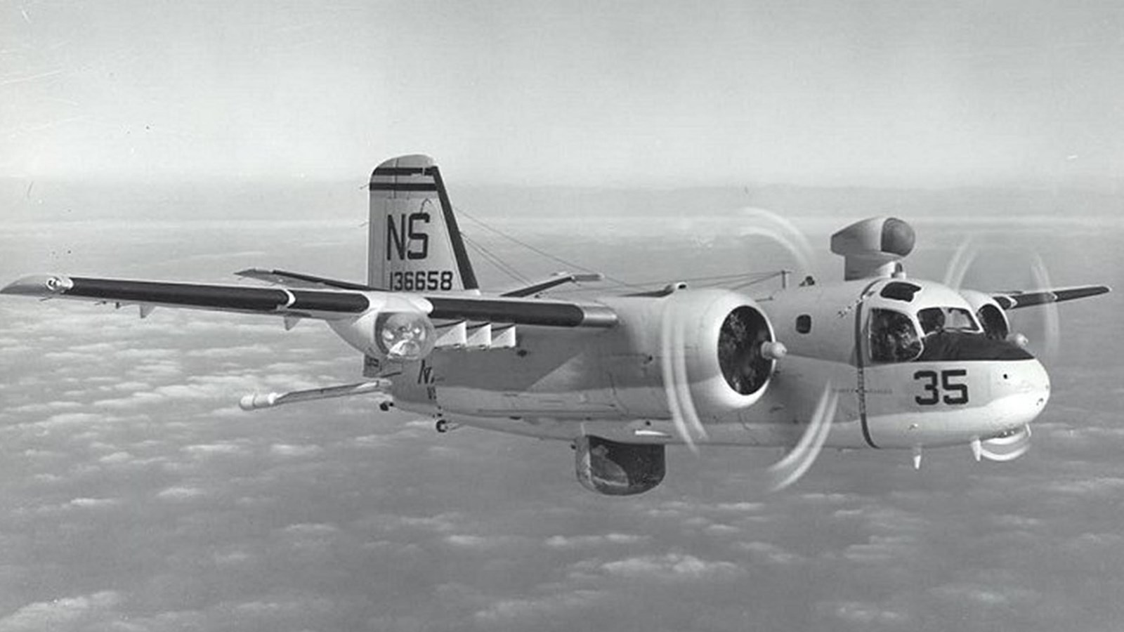
World War II Coastal Lookout Stations
The Coastal Lookout Stations, Offshore Patrol and Inshore Patrol, which made up the Local Defense Force, communicated through an operational battle circuit. Each Station was allotted one portable radio, a transmitter to be placed on a roof or tower, and one receiver. By December 30, 1941, the Inshore Patrol had twelve vessels and the Offshore Patrol three. Among the latter was the Hermes, which had long patrolled the islands and served as free transportation for island dwellers. During the war it was credited with sinking a submarine outside San Pedro Harbor.
In January 1942, Coast Guard Inshore Patrol Boat 411 carried Commander H. O. Hill, Officer in Charge, Coastal Lookout Stations, on a tour of the Channel Islands to reconnoiter and to plan development of the Stations. Of the several islands he visited, San Nicolas and San Miguel gave the most trouble in landing their 17-foot surfboat. This experience convinced him that all provisioning would have to be done in summer months.
At this time San Miguel had no pier and Hill envisioned that building equipment, provisions and men would be landed through the surf at Cuyler Harbor. Hill wrote that the "island had a passable airplane landing field [Hammond Field] about 1800 long. It is well marked and has the standard wind sock." The field was smooth, he reported, and because of the forceful winds, airplanes of a fairly large size could land.
Hill chose 830-foot San Miguel Peak, the highest point on the island, as the new site for the Lookout Station, which at the time of his visit was temporarily situated in the Ranch House. He recommended that a road be built from the Ranch House to the planned site and described it as a simple matter. Hill also wanted a road leading from Cuyler Harbor to the top of the mesa resurfaced as the Lester's sled road would not do to transport supplies and equipment of any great weight. A request for permanent structures at the Lookout Stations was turned down in February 1942, so locally manufactured prefabricated buildings were used throughout the war. San Miguel received a two-room barracks building with glass windows, which was set up near the Ranch House on the east side. Photos showed a shack beside the observation tower.
When Hill visited San Miguel, the Lesters were billeting Navy men at the Ranch House. They climbed to the roof to stand their watches and had a 25-watt radio transmitter and a receiver. Hill mentioned that it was possible to reach the planned new site by automobile even without the road. He had perhaps ridden in the Lester's old Ford given to them by a newspaper publisher. Hill was impressed with Lester, a man he described as "distinctly of a high type of intelligence."
Eventually the Navy bulldozed a road from the ranch to the wooden lookout tower and on to Point Bennett; service men called it the Road to Mandalay. Telephone lines completed the basic improvements of the San Miguel Lookout Station.
On May 27, 1942, a state of emergency was declared throughout the Western Sea Frontier, and a special line of patrol boats was established well to seaward to guard against surprise attacks. By this time, lookouts were located at nine island stations: Anacapa Island; Santa Barbara Island; Pyramid Head, San Clemente Island; Wilson Cove, San Clemente Island; San Miguel Island; San Nicolas Island; Santa Catalina Island; Santa Cruz Island; and Santa Rosa Island.
Anacapa's radio telegraph call sign was NSK1, San Miguel's NPK4. San Miguel by then had a 100-watt transmitter. All lookout stations were supplied with sidearms and/or rifles and binoculars, and their personnel were trained for night lookout and for recognition. San Miguel and the other islands had no gun emplacements, a fact noted by a map in the Fort MacArthur Library published by their Engineer's Office. It showed batteries and searchlights up and down the coast, but the Channel Islands were not even drawn on the map. After the Battle of Midway in June of 1942, military leaders were convinced that the west coast was out of danger. This thinking is reflected in the lookout stations: development up to that date but none after.
Patrol boat reports throughout the war recorded the logistical support they provided for the stations: relief of personnel, medical aid, and deliveries of supplies. No station activity beyond the routine disturbed life on the islands according to the messages sent to the Section Base in San Pedro. While some of the Coastal Lookout Stations extended their activities to Army flash reports and San Clemente transmitted vessel reports, neither Anacapa, San Miguel, nor Santa Barbara Islands were assigned these duties.
The Navy abolished the Coastal Lookout System on July 1, 1945. Then on July 17, the Commandant of the 11th Naval District at San Diego took thirteen lookout stations out of service. These stations included seven island stations, among them San Miguel, Anacapa and Santa Barbara Islands. The order asked for deletion of radio call signs and transfer of radio equipment to San Diego. San Miguel, however, received a new call sign for official weather reporting. Coast Guard Cutters including the Hermes, which had so long served the islands, resumed regular peacetime activities. Most of the poles and wire of the communication line installation at San Miguel were removed from the island, but the tower and temporary buildings near the ranch house remained on the island after the war.
B-24 Crash, 1943
A military aircraft accident brought tragedy to San Miguel Island during World War II. On July 5, 1943, a B-24 bomber crashed on the north side of Green Mountain, killing all 12 men aboard. The "Liberator" was part of a fleet of new bombers that eventually numbered 18,000. The air armed forces used dozens of Liberators for training, using mostly young and inexperienced crews, which led to numerous crashes. "It had a long, thin, high lift wing which made it suitable for long distance bombing missions . . . generally it was not regarded as the safest aircraft in the sky," wrote crash historian R. W. Koch. "Yet, it played a major role in helping to win the war in Europe and Asia." The 56,000-pound planes were equipped with four 1,200 horsepower engines, had a maximum speed of 303 mph and a range of 3,200 miles. The B-24-E Liberator in question was built by the Ford Motor Company in Michigan and was new; its personnel was assigned to the 2nd Air Force, 34th Bomb Group, 7th Bomb Squadron at Salinas Army Air Base in Salinas.
The plane, with a crew of 12 aboard, had been searching for ten crew members of another B-24 that had crashed near Santa Barbara the day before after the crew had bailed out somewhere near the coast. The search plane left Bakersfield towards Santa Barbara, and was to continue to Point Conception and Salinas, but disappeared after reporting over Santa Barbara at 8:00 a.m. Evidently, the B-24 flew too low in foggy conditions while approaching Point Conception; the ceiling that day was 300 to 500 feet and the plane had no radar. The bomber struck the side of 831-foot Green Mountain and practically disintegrated, killing all aboard and spreading wreckage over an area of up to ten acres. Although the crash site was only a short distance from the Coastal Lookout Station, it was at least two miles from the barracks and no one heard the impact and no one saw the wreckage.
Robert Brooks came on the wreckage some time later when he was gathering sheep near Green Mountain, although government records state that sailors based at the island's radio/weather station found it on March 19, 1944. Whatever the date, the late discovery reflected on the diligence and state of readiness at this lookout station at the time of the crash. Stan Sokolis and Robert McKee, stationed on the island radio unit, reportedly assisted in the task of removing the bodies and salvaging important plane parts, although much of the scattered wreck was left on the site.
In 1954 some hikers found the wreckage and human bones. Authorities were notified who could not find a record of the wreck; they dispatched an investigation team on a Coast Guard cutter in the night. Unfortunately, the cutter collided in the darkness with the yacht Aloha off Point Mugu, killing two aboard. After rescuing three survivors the cutter returned to Los Angeles, then again commenced its mission to San Miguel Island. There they found the wreckage but soon received a radio message stating that records of the wreck had been located and that the investigation was off.
Post World War II: Bombing Range Established
Pacific Coast facilities and personnel took a major role in national defense efforts during World War II (1941-1945). The military used the Channel Islands and adjacent mainland areas to a limited extent for armed defenses but mainly as supply depots for the Pacific war effort and for surveillance and detection of incoming enemy ships and aircraft. Continued activities after war's end saw the southern California area become one of the nation's leading locations for testing and innovations in new war technology.
In 1948 the Commandant of the 11th Naval District, based in San Diego, administered San Miguel Island. Robert L. Brooks held a revocable grazing lease on San Miguel Island, the one he had held continuously for 33 years. In July 1948, the Navy exercised its right to revoke and gave Brooks 72 hours to remove his sheep and other property from the island. He was told the Navy would begin immediately to use the island as a bombing range.
Joint Use: Navy and Air Force
The San Miguel Island Bombing Range Danger Area appeared in the Coast Guard Notice to Mariners December 17, 1948, and in the following year was subject to joint use by both Air Force and Navy. Pressure on it was so heavy that scheduling had to be made on a weekly basis even though squadrons were asking for use on an indefinite basis. Moffett Field found it most satisfactory for its squadrons that required the use of a high altitude target. Castle Air Force Base at Merced wrote that the practice bombing they conducted at San Miguel included dropping of 4,000 pound light case bombs at altitudes up to and including 30,000 feet.
The 11th Naval District records contained numerous reports of unauthorized surface craft "fouling the waters surrounding San Miguel Island" and interfering with the bombing missions. For example, in October 1949 private boats around San Miguel were so frequent that the commanding officer of the 93rd Bombardment Wing stationed at Castle Air Force Base complained they almost prevented use of the bombing range. Fishing craft ignored attempts of the pilots to signal them out of the area and the planes would return to base, at great cost in dollars to the American public. To solve this the Coast Guard was asked to include San Miguel in its patrol pattern but it had no forces available for such patrols on a regular basis.
Squadrons had to resort to red flares for range clearance or to dropping message blocks close aboard the surface craft. The Bombing Range users were particularly annoyed because range time came on a priority basis, and once lost had to be rescheduled. Fleet squadrons used live bombs. Acting Commander Harper of Composite Squadron Five, Naval Air Station, Moffett Field wrote that even when they attempted to warn boats away by low passes with bomb bays open the signal was not understood by boats. Composite Squadron Six at Moffett Field, practicing high altitude bombing, used Prince Island as an aiming point for radar bombing and dropped 100-pound General Purpose type bombs. The commanding officer observed that most violators were in Cuyler Harbor. Four of his planes had to circle the area for over an hour before they were able to clear the area of pleasure craft and begin to carry out their mission. In April 1950 the San Miguel Island bombing range was included in the Permanent Danger Area by the Coast Guard in its "Notices to Mariners" which was issued in addition to the weekly Notice. Further, warning signs were posted on the island.
San Miguel Island Bombing Range was closed June 16, 1950 to July 9, 1950 so that Robert L. Brooks could come out to the island and remove his livestock. The curator of geology and anthropology at the Santa Barbara Museum of Natural History, Phil C. Orr, his assistant Richard Finley, and Mr. David Gray volunteered to herd sheep in order to study the natural history of the island. Don Butler and the Brooks ranch hands combed the hills and ravines on horseback driving the sheep into corrals and to the loading pier. On June 25, 1950, and while the range was closed, the Korean War broke out thus giving cause for greater impact on scheduling time for the island bombing range. Carrier based squadrons such as those stationed at North Island were prime users.
Condition of San Miguel Island in 1961
Bombing continued through the 1950s, and when scientists came on the island in the early sixties they reported finding shrapnel and bomb casings all over the island. E. R. Blakely, who was there in April 1961, said they landed their plane on the airstrip near the Ranch House. During World War II, the army had graded the strip and used it for big planes, but in 1961 it had large trenches across it, one especially large and dangerous. The observation tower on San Miguel Peak still stood, and the wreckage of the B-24 bomber that had crashed in 1943 lay on the northeast slope of Green Mountain. Both burros and sheep roamed the island, but they were being run down and shot whenever possible by Navy personnel.
Blakely found leaks in the Ranch House roof, but vandals had not really gotten to it as books and china were in place and people lived in it now and then. The wall next to the house had fallen down. Blakely found the walls papered with newspapers interesting to read. The barn was partially standing and the pre-fabricated Navy barracks of two rooms was good enough to stay in.
Pacific Missile Range Administration and Use
In 1961 the Navy refused to give up San Miguel Island to a National Park plan then being drafted for several of the Channel Islands. A letter in 1962 from Kenneth E. Be Lieu, Assistant Secretary of the Navy, to Secretary of the Interior Steward Udall clarifies why they would not release it in the foreseeable future: "One of the most important aspects of the operations conducted from the facilities of the Pacific Missile Range is the launching of missiles into polar orbit. Flight paths go directly over and adjacent to San Miguel Island. The easterly impact limit of the azimuths required for these launches passes just west of Santa Rosa Island. All the area west of this line is subject to impact by missile pieces as a result of destructive action during missile launching operations. The Pacific Missile Range safety policy requires that all civilian and non-operating personnel be evacuated from within this danger area during southerly launchings. The current number of launchings already makes joint use impracticable and their number is increasing rapidly. "
In 1963 the Department of the Navy transferred all the plant account and security responsibility for San Miguel Island from the Eleventh Naval District to the Commander, Pacific Missile Range. This was the same year that Navy and Interior signed an agreement to jointly protect natural values and historic and scientific objects on San Miguel and Prince Islands. Both agreements recognized priority of military uses.
The U. S. Navy uses of San Miguel Island evolved out of the country's early efforts in defense and surveillance, and saw its heyday during the Cold War era as the United States found itself at odds with the Soviet Union and China. After witnessing the destructive power of German buzz bombs on European cities and the United States' nuclear attacks on Japan, governments and military leaders came to realize that technological advance would define future warfare. The Navy, breaking with its own tradition of fiscal prudence and minimal research and development of new technology, began after the war to expand research into new defense technology. The Navy more than quintupled its expenditures for research and development in ten years' time which also brought a huge increase in lucrative contracts to defense industries. Missile technology, largely developed by the German military, came to the forefront of national defense, as control of the seas and air space became the focus of military strategies. The Pacific Ocean provided an ideal testing ground and the various Channel Islands fell into play as integral units to the successful testing and maintenance of the nation's guided missile defense systems.
The U. S. Navy established a field test site for the Special Weapons Tactical Test and Evaluation Unit in 1943 at Point Mugu, a former swamp located south of Ventura and Port Hueneme; the location provided "an overwater space through which missiles can be launched while data on their performance are being obtained in such a manner that correct evaluations of their performance can be made." Headquarters for the unit were located at Traverse City, Michigan. The use of airborne weapons had advanced during World War II to the point that military leaders realized the importance of such modern systems in global warfare and defense. On the urging of Navy Commander Grayson Merrill, the Navy created its Pilotless Aircraft Unit Detachment at Point Mugu in 1945 where engineers tested guided missiles such as the Loon using the expanse of ocean, which it called the Instrumented Sea Range, as a proving ground. The offshore islands provided locations for monitoring missile paths and, in some cases, acting as targets, dummy ships at sea as it were. According to Navy historian Maxwell White, the islands were a major consideration in the selection of Point Mugu as the location of the United States' first over-water missile testing range.
During the 1940s the Navy tested a number of guided missile systems such as the Gargoyle, Gorgon, Lark, Little Joe and the Loon which figured in the ship-to-shore bombardment of Japan late in the war; systems tested in the 1950s and accelerated by the Korean conflict included the Regulus I, a submarine-to-shore missile; Regulus II, an early supersonic missile; and various versions of the Sparrow, launched from a plane for airborne targets. The government owned and controlled three of the Channel Islands. (San Miguel, San Nicolas and San Clemente) and made use of their entire landmasses for testing, targeting and facilities. The Navy also placed facilities on privately owned Santa Rosa and Santa Cruz Islands.
The U. S. Naval Air Missile Test Center (NAMTC), as the Pilotless Aircraft Unit had been renamed in 1946, made plans in 1948 for major facilities at Point Mugu and the Channel Islands. With the major installations to be constructed at Point Mugu and San Nicolas Island, plans included a radio communication center on Santa Rosa Island and a fully staffed "observation site" on Santa Cruz. Development of missile defenses expanded rapidly in the 1950s. The Bullpup air-to-surface bomb, the first "smart" missile which could attach itself to a target, was put into testing in 1953 and remained, in its many stages of development, an important weapon into the 1970s when it was supplanted by the Walleye that used television for homing in on its targets. By 1956 the NAMTC employed 4,800 people and operated out of a $50 million plant; it was, along with Navy's China Lake facility in the Mojave Desert, the military's most important missile testing facility.
In 1957 President Eisenhower called for the national testing ranges to be available to all of the armed services. On June 16, 1958 the Navy joined with the Air Force's Atlantic Missile Range at Cape Canaveral and the Army's White Sands Missile Range in New Mexico to create the Pacific Missile Range (PMR), which became known as the Cold War's "Keeper of the Pacific." The following year the Naval Missile Center was created exclusively to test and evaluate Navy missile systems, in effect splitting the mission of the old NAMTC. By the early 1960s the PMR owned or held interest in properties at Pt. Mugu, Pt. Arguello and six other mainland coastal sites, San Nicolas, Santa Cruz and San Miguel islands, two inland sites in Nevada and Utah and sites on Hawaii, Midway and Wake Islands. In 1963 the Air Force took over the facilities at Pt. Arguello and most Pacific range sites, but the Navy continued to control the PMR with its facilities at Point Mugu, San Nicolas Island and Santa Cruz Island. Following these developments, the PMR in 1963 took over San Miguel Island from the 11th Naval District.
The following year, 1964, the Pacific Missile Range began some Land Mass Background studies and employed San Miguel Island. The first was to test radar guidance systems. They were testing surface-to-air and surface-to-surface weapons. The missile would be on a boat in the channel and launched southerly over the island into the defined range area to see how the radar guidance would react to land clutter. PMR made two launches of the Talos missile with this in mind in 1964. One missile used an active radar seeker in its final guidance phase. The problem lay in its being confused by a landmass. For example, the Russian Komar submarine would run in near an island and the radar on Talos would lose the Komar and try to hit the island; thus PMR was trying to improve the radar guidance so it would not leave its target when it made the test launches over San Miguel Island. Since the tests, the instrumentation has been improved. The radar locks onto a moving target and the landmass in the background will not cause it to break lock. PMR only ran two operations of this type but probably several rehearsals. The fact remained, however, that the requirement might arise for upcoming weapons and San Miguel had a unique location for such launches. Secondly, it could easily be cleared of people by the National Park Service.
A second use for San Miguel by PMR was that of testing landfall when a ship target was anchored in front of it. Exercises were carried out to see if a missile could distinguish between the land (San Miguel Island) and the target. If the background confused the missile then it was not useful. Thirdly, the island served to test airborne systems. Radar has different characteristics over land than it has over water. PMR wanted to know if San Miguel's land mass would confuse the missile electronic systems and the radar of a plane that was pursuing another aircraft over ocean and then over land.
February and March 1965, San Miguel, San Nicolas and San Clemente Islands were used in a major fleet exercise involving eighty ships and 70,000 Navy-Marine Corps personnel. By this time the Navy had installed a series of range poles near the west end to guide aircraft in sighting.
On May 3, 1965, Channel 13, KCOP-TV carried a program called "The Secret of San Miguel" which by its nature encouraged people to go out to the island and search for buried treasure. This alerted PMR to the fact that no public announcement had ever been made to the public that there was a danger of unexploded ordnance on San Miguel. Captain H. S. Bergman suggested that the Navy would be in a better position to deal with such TV programming if it made a sweep for bombs, made a public announcement, and then wrote to the TV programmers. PMR proceeded rapidly with plans to sweep bombs from San Miguel, and during the period of May 17 to May 21, 1965, ordnance decontamination was conducted. The search was reported as a 100% surface coverage, but due to the continuous high winds and shifting sand it was believed additional items of ordnance might be revealed. The island was considered safe for personnel occupancy, but personnel should be advised of the hazards associated with unexploded ordnance.
During the week of June 17, 1965, Bullpup missile operations started on the island. Initial Bullpup firings were aimed at a barge anchored in Cuyler Harbor 700 yards southwest of Bat Rock. Range officials reported that the island's "varied terrain permitted targets to be concealed and protected as they would be in actual combat." Use of the tactical firing area on San Miguel was intended to provide Navy and Marine Corps pilots with experience in the use of the Bullpup missiles against combat type targets. PMR recited that in selecting sites for the land targets they had avoided areas of any archaeological and zoological interest. Before each mission, the island would be cleared of people and warning area notices would be issued to mariners and airmen. The first press releases mentioned five hundred pound live ordnance, but either due to public pressure or tactical changes, this terminology was deleted from releases on June 16, the day before the firings began. As a tactical target area for fleet training, San Miguel was perfect. Planes could approach the target area from any direction at 0-20,000 feet using various attack modes. A launch aircraft with a chase plane made the attack and called the hit based on visual observation. A helicopter or other aircraft performed surveillance and took photographs of the missile impact. Both practice and live warheads were approved.
The Navy was anxious in 1965 to find the locations of archeological sites so that they could avoid destroying them when they set up targets for tactical bombing missions. A Navy helicopter flew Charles Rozaire and George Kritzman out to San Miguel August 19-27, 1965 to map archeological sites, and it was obvious from Rozaire's report that the Navy had habitually taken care of his transportation and made the photo lab at PMR available to him. Rozaire kept the Navy informed about the conditions of buildings and presence of vandals on the island. In that trip he found the Navy barracks or shack much deteriorated, the no trespassing signs torn down, and the roof of the Ranch House down.
Danger Zone, 1965
The Navy eventually got tired of small boat owners who would not heed notices to stay out of San Miguel waters during tactical exercises and of vandals who came on the island and tore down metals signs bolted to steel posts, shot up the buildings, and used the seals for target practice. It was not the general public, but as one official put it, a small cantankerous group.
August 12, 1965, the Navy applied to the U.S. Army Corps of Engineers, which regulated navigable offshore waters, for a designated danger zone around San Miguel Island. Accordingly, October 11, 1965, Major Robert T. Ojendyk, Corps of Engineers, established a zone at the east end or half of the island plus a three-mile offshore area on all sides involved.
According to the regulations, the danger zone was to be open to fishing and general navigation except during firing. Anchoring or loitering of vessels was prohibited within the zone. Landing or going ashore was prohibited without prior permission of the Commander, PMR. Firing information was made available and paid public notices were inserted in local newspapers (see map, "San Miguel Danger Zone").
Letters opposing the establishment of a danger zone flooded the desk of Major Ojendyk: fishermen, abalone hunters, boaters, zoologists, archaeologists, Western Oil and Gas Association, the Sierra Club, and Department of Fish and Game, Yacht Clubs, and State Senator Alvin C. Weingard (D) of Santa Barbara. Only the City of Santa Barbara, it seemed, had no objection. The Sierra Club and the Santa Barbara Yacht Club wanted a radical solution: take San Miguel out of the Navy's control. Gas and oil interests desired drilling sites uninterrupted by hazardous operations. Conservationists wanted the public wholly excluded. Fishermen desired unlimited fishing. Yachtsmen wanted to anchor and go ashore. Thus, a solution for one group would offend another. PMR answered each group, emphasized that the zone was closed only during times of actual firing, and retained the zone.
In 1966 PMR utilized San Miguel Island for fleet pilot training and for proficiency training in the Bullpup, FFAR (folding fin aircraft rocket), bombs, the Zuni Missile, and 20mm cannon weapons.
In September 1966, PMR was preparing a training area on San Miguel for the Walleye, Condor, and other systems. It had a Nike target and inflatable Bullpup targets on shore. Simulated truck convoys, SAM sites, tanks, and revetted aircraft targets were being installed on the southeastern portion of the island between the escarpment and the beach. The latter was primarily for the aircraft squadrons of the First Fleet. Additional targets such as bridges and RF radiating equipment were planned for the near future. PMR reported to Naval Air Systems Command in Washington that installation of land targets would create increased use of the island by Fleet squadrons, also U.S. Marine Corps squadrons, who preferred the land targets to the barge targets. In 1966, Fleet missile firing ships were requesting shore targets for surface-to-surface missile testing and pilot spotting training. PMR correspondence argued that there were no practicable alternatives to the use of San Miguel Island. Com. R. N. Sharp, PMR, wrote on September 9, 1966:
"Areas such as San Nicolas Island, San Clemente, Chocolate Mountain, El Centro, Yuma, Twenty-Nine Palms, Mojave B. and the Naval Ordnance Training Station, China Lake are either already overly scheduled, contain populations which must be evacuated, lack adequate instrumentation or area, permit no offset firing, restrict approaches to one or two prescribed headings at fixed altitudes, or require ground control of aircraft at all times. While these areas are quite adequate for the purposes for which they were designed, they are unsuitable to the purposes now required for missile testing and practice firing. Among other things, the circumstances of firing are so artificial as to lack the realism necessary for much needed pilot training. San Miguel, on the other hand, is both unique and ideal. Situated as it is at the westerly end of an island chain, wholly unimproved and unpopulated, it presents a minimum safety hazard, while offering maximum security. With targets available onshore, just offshore, and 10 to 15 miles offshore, it provides realistic practice in a well-balanced instrumented area. No other target areas in the United States allow for attack by two or more aircraft at once, or permit pilots to determine their own altitude, range, angle, and release position. Logistics problems are non-existent, at least from El Toro, Alameda, Lemoore, also the Fleet. The area is accessible without the need to overfly populated areas. In final substance, it is the last such area left. "
As Captain H. S. Bergman pointed out in preparing the draft for the above, squadrons were coming to PMR from Norfolk and from Cherry Point only so that they could use San Miguel. Many young pilots preparing for a tour of duty in Vietnam were firing for the first or second time and needed realistic practice with the variability of approaches only San Miguel could offer them. The money spent by the American public on missile testing and on tactical missions was so great that to give up or curtail the use of San Miguel in the program seemed irresponsible.
A second major reorganization occurred on July 1, 1975 merging the Naval Missile Test Center and the Pacific Missile Range into a single body, the Pacific Missile Test Center (PMTC). The following year the Departments of the Navy and Interior agreement regarding San Miguel Islands was amended to allow the National Park Service greater administrative latitude, including authorization to expend NPS funds for study and management of the island resources. San Miguel Island lay in a strategic portion of the PMR's Sea Test Range, within that area designated W-289N. On land, targets were no longer listed, and in 1976 the only Pacific Missile Testing Center asset on the island was an automatic weather station, powered by a twenty-five watt generator. This small device was protected by sturdy fencing from the ever-present threat of vandals on the island. A non-instrumented target barge was anchored approximately one mile south of the island's eastern tip. During tactical exercises, all boats and people were warned to stay out of the surface danger zone which surrounded the eastern half of San Miguel, but they were allowed to remain on the west end of the island.
The number of air to surface exercises decreased during the 1970s and 1980s. Both the Point Mugu area and San Nicolas Island were heavily instrumented, thus defining the southwesterly geographic quadrant extending seaward from Point Mugu as essential to the Navy mission. Meanwhile, the Department of the Interior leased the oil industry about 33 square miles of the sea area southeast of Santa Rosa Island. At the time it was considered that if Navy squadrons were deprived use of the San Miguel Island area, 100 enroute miles would be added to 80% of all training sorties originally planning to use the San Miguel target. Squadrons originated from Miramar, North Island, Lemoore, Moffett Field, and other bases. Further, and of greater importance, it would place the training squadrons in direct competition with vital research and training programs for use of that mission-essential area previously described, thus derogating both efforts.
In 1977 an Operations Officer at Lemoore stated that Attack Squadron 122 was scheduling operations at the Pacific Missile Test Center. The plane they used was the A-7, a single-engine jet, land or carrier based. Lemoore opened in 1961 at which time all training squadrons used the A04, a single-engine jet. In either case, students needed the type of training the San Miguel Island tactical mission provided to fulfill their syllabus work. Their training manual recited that live ordnance could be used only on San Clemente Island, so Naval air strikes at San Miguel were with inert ordnance called Blue Whistlers: a watersand filled thin shell twenty-five pound blue bomb with a spotting charge. The blue indicated its inert composition.
The Navy considered that San Miguel Island could be defined as a strategic site for the installation of a tracking radar or a radar for tracking test missiles launched from PMR, and for a telemetry station to receive radio signals from a missile in flight to measure certain parameters such as acceleration, control angles, pressures and temperatures. However, changes in the needs of the Navy and the establishment of Channel Islands National Park in 1980 placed San Miguel Island under the management, although not ownership, of the National Park Service.