Last updated: June 18, 2026
Place
Lipan Point
NPS/T. Karlovetz
Quick Facts
Location:
Desert View Drive
Amenities
4 listed
Historical/Interpretive Information/Exhibits, Parking - Auto, Scenic View/Photo Spot, Wheelchair Accessible
Beginning June 22, 2026, Lipan Point and Lipan Point Road on Desert View Drive (Highway 64) will temporarily close to all visitor use to allow for critical rehabilitation and maintenance work of the overlook. The closure is expected to remain in effect through December 23, 2026.
The project will include asphalt removal, trail reconstruction, and trail resurfacing to improve visitor access and preserve the site for future use. Closing the area is necessary to protect visitors from construction-related hazards, including heavy equipment operations, construction materials, noise, and dust.
During the closure, the Tanner Trail will remain open. Visitors accessing the Tanner Trail must park at “No Name Point,” located approximately 1,000 feet west of Lipan Point Road along Highway 64. From there, hikers will need to walk to the Tanner Trailhead. Parking along Highway 64 near the Lipan Point Road intersection will not be permitted.
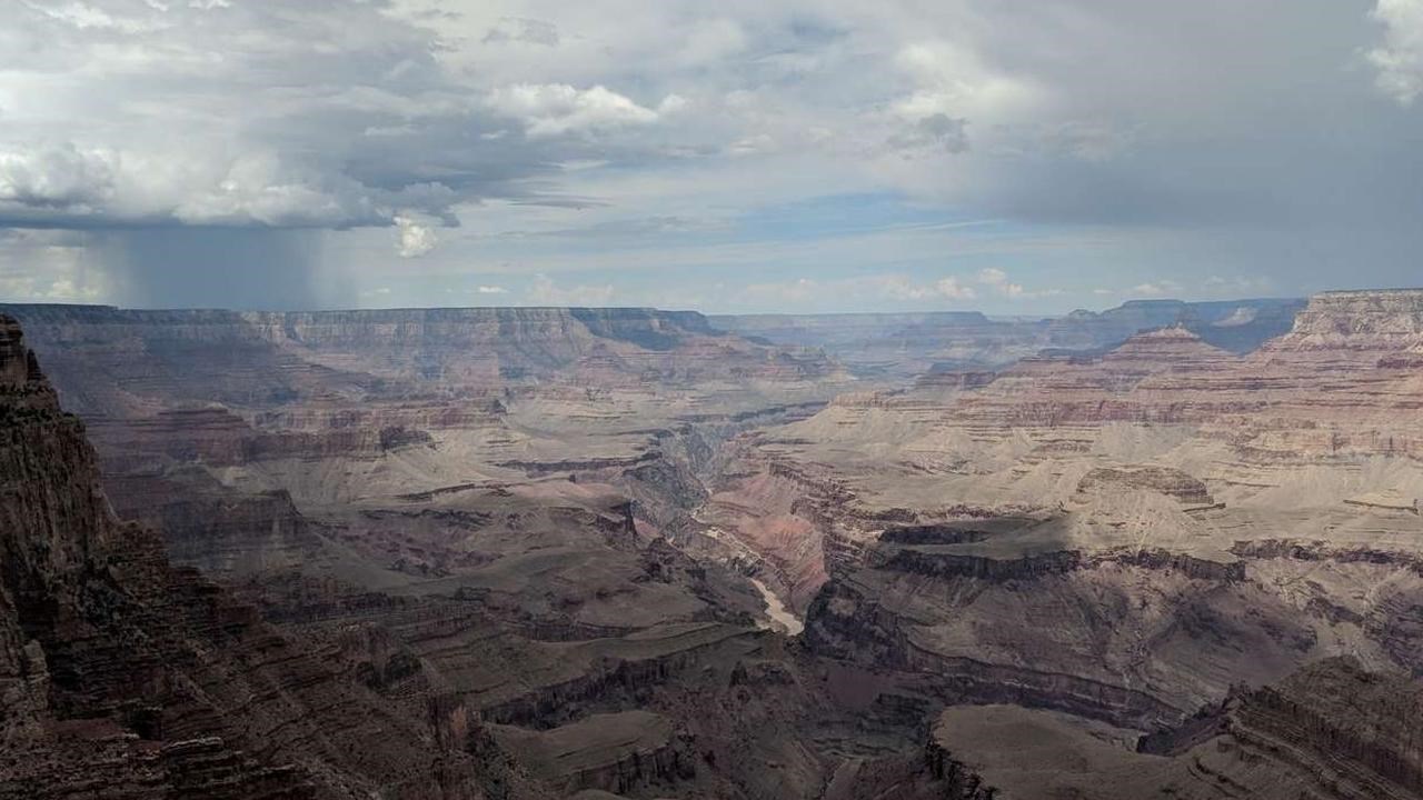
Lipan Point features some of the widest and most expansive canyon views along the South Rim, as well as the longest perspective of the Colorado River. This makes it an ideal spot to enjoy sunrise, sunset, and the night sky.
On a clear day, you can see the Vermillion Cliffs 45 miles (72 km) to the northeast and the curving river to the west as it enters the Inner Gorge of the canyon.
This spacious panoramic view features many spires, buttes, and temple formations that resemble ancient pyramids. Westward views seem to stretch on forever, and the canyon walls present a tapestry of blacks, grays, reds, browns, and tans in a wide variety of rough and smooth textures.
From here, you can look down to the very bottom of the canyon to view the mighty Colorado River and the tilted layers of the Grand Canyon Supergroup. These unique rocks are exposed in just a few places within the canyon, and are visible at only a few viewpoints. Hidden among the titled layers and cradled by the river is Unkar Delta, where ancient Puebloan people once cultivated beans, corn, and squash.
Listen for the roar of Hance Rapid, almost four miles (6.4 km) away, and for the cries of hawks and other raptors along this important migration route. Forests on this side of the canyon and on the North Rim, just eight miles (13 km) away, make Lipan Point an ideal spot for birds crossing the canyon.
Geology in Depth: Grand Canyon Supergroup
The tilted strata visible deep within Grand Canyon at this viewpoint are part of a series of rock layers known as the Grand Canyon Supergroup. From here, look across the canyon to see them in the walls of the North Rim. The lower half of the Supergroup, known as the Unkar Group (1255-1100 million years old), was deposited by north-flowing paleorivers carrying sand and mud from now-eroded mountains in what is now the region of West Texas. The upper half of the Supergroup (which is not visible from here) is known as the Chuar Group (780-729 million years old), which was deposited in a shallow sea while all of Earths' continents were joined together as the supercontinent Rodinia. Stromatolites in both groups record single celled life that existed in shallow seas. Chuaria fossils, also found within these layers, are small 750-million-year-old single-celled fossils that record a time of diversification of microbial life.
In this part of the canyon, instead of being confined by the hard Vishnu basement rocks within the narrow Inner Gorge to the west, the Colorado River instead winds its way through layers of soft, purple sandstone belonging to the Dox Formation. This is why Lipan Point features such spectacular views of the river. Above these purple layers is the black Cardenas Basalt, formed by lava flows erupting due to continental collisions during the formation of the supercontinent Rodinia over one billion years ago. To the west, one can see another stretch of river cutting down through layers of purple, orange, and brown rocks; these are the Bass Formation, Hakatai Shale, and Shinumo Sandstone, respectively. One can also see where the river crosses from these layers into the unlayered black and pink Vishnu basement rocks underneath to begin forming the Inner Gorge.