Last updated: May 12, 2021
Place
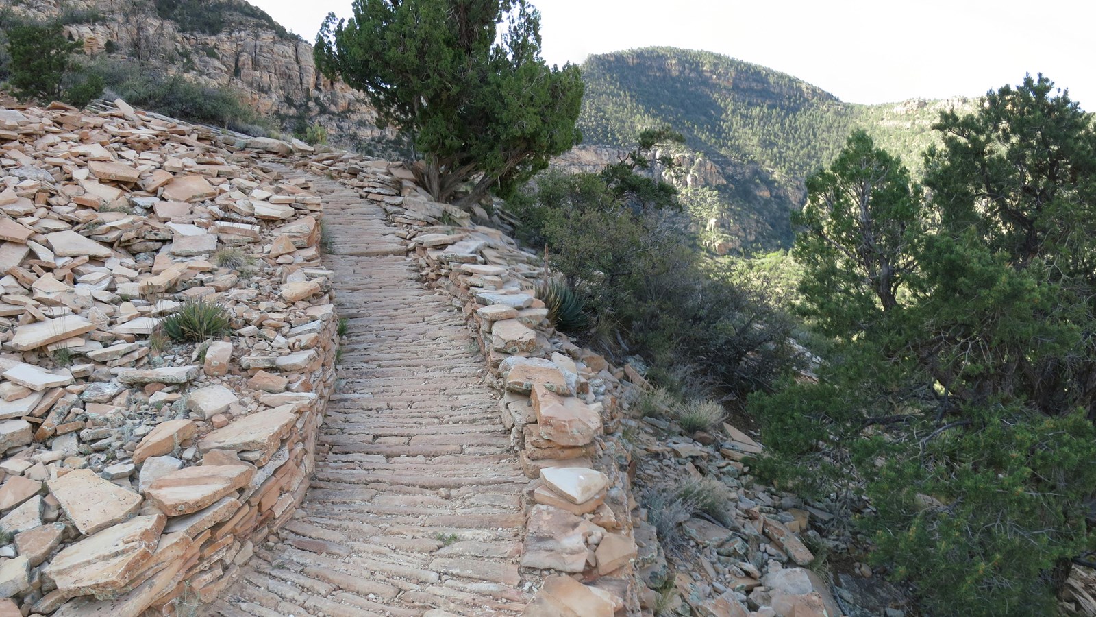
Hermit Trail Grand Canyon
NPS/Mike Quinn
Quick Facts
Amenities
3 listed
Scenic View/Photo Spot, Trailhead, Water - Non-Potable
Louis D. Boucher, the "hermit" of Hermit Creek basin, lived in this area for 20 years. Boucher built the Boucher Trail (west of the Hermit Trail) and seasonal residences at Dripping Springs and near Boucher Creek. Though socially active in the South Rim community, residents labeled Boucher a hermit because he lived alone.
The modern trailhead is located just west of Hermits Rest. Follow the dirt road from the restrooms to make your way to the trailhead. There is no parking for day hikers at this trailhead when the Hermit (Red) Route shuttle is active; day hikers must ride the free shuttle bus to reach the trailhead.
For experienced desert hikers only.
Water from springs must be purified.
Allow extra hiking time; conditions are more difficult than on the Bright Angel and South Kaibab Trails.
Trail Desciption
The upper section of the Hermit Trail is quite steep, dropping almost 2,000 vertical feet (610 m) in the first 2.5 miles (4.0 km). Passage through the Kaibab Formation and Coconino Sandstone is via well-defined switchbacks. Most of the Hermit Trail was originally surfaced with large hand-fitted rock slabs that created a smooth walking surface. Ongoing erosion has claimed much of this remarkably labor-intensive paving, but a few isolated fragments survive, especially in the Coconino Sandstone. Fossilized animal tracks have been noted in many locations throughout the canyon, but they were first studied in detail along the Hermit Trail. Observant hikers can see a few of these fossilized lizard-like tracks in the lower half of the Coconino Sandstone.
The trail enters Waldron Basin, a quiet, isolated pocket within the Hermit side canyon, at 1.2 miles (1.9 km). The Waldron Trail junction is encountered soon after at 1.5 miles (2.4 km), followed by the Dripping Springs Trail junction at 1.75 miles (2.8 km). To continue on the Hermit Trail, stay right at both junctions. Dripping Springs, however, does make an excellent day hike destination. After the Dripping Springs trail junction, the Hermit Trail drops down along the east side of Hermit Creek gorge. Santa Maria Spring is reached at 2.5 miles (4 km) along the trail, offering a trickle of water and a historic masonry rest house which provides welcome shade during the summer.
Continuing on the Hermit Trail past this point is generally not recommended for a day hike during the summer. During cooler months, Lookout Point, an additional 1.5 miles (2.4 km) down the trail from Santa Maria Spring, is also a reasonable single-day option for those seeking a longer hike. Between Santa Maria Spring and the top of the Redwall Limestone at Cathedral Stairs, the Hermit Trail is characterized by long traverses through the Supai Formation. This section of the trail is tucked up against the west facing walls of the south rim and offers hikers a period of extended shade during the hotter months.
At Cathedral Stairs, the descent becomes unrelenting. An endless series of rocky switchbacks eventually leads hikers through the Redwall cliff and down the west-facing talus below Cope Butte to the intersection with the Tonto Trail. The Tonto Trail is an important Inner Canyon route that allows access in both directions along the Tonto Platform, east to Monument Creek, west to Hermit Creek. Turn left (west) and follow the Tonto Trail about a mile to the Hermit Creek campsite. Be sure to walk downstream a short distance during your stay at Hermit Creek, or even descend all the way to the Colorado River at Hermit Rapid.
Destinations
For experienced desert hikers only.
Waldron Basin
3 miles (4.8 km) round trip / 2-4 hours / 1,240 feet (378 m) elevation change
Dripping Spring Trail Junction
3.6 miles (5.8 km) round trip / 3-4 hours / 1370 feet (418 m) elevation change
Santa Maria Spring
5 miles (8 km) round trip / 4-6 hours / 1,680 feet (512 m) elevation change
Dripping Spring (via the Dripping Spring Trail)
7 miles (11.2 km) round trip / 5-7 hours / 1040 feet (317 m) elevation change
Breezy Point
11 miles (17.7 km) round trip / 6-9 hours / 2,220 feet (677 m) elevation change
Tonto Trail Junction
Not recommended to hike to Tonto Trail Junction and back in a day.
14 miles (22.5 km) round trip / 3,430 feet (1,045 m) elevation change
Hermit Creek
Not recommended to hike to Hermit Creek and back in a day. Water requires purification.
16.4 miles (26.4 km) round trip / 3,740 feet (1,140 m) elevation change
Colorado River / Hermit Rapids
Not recommended to hike to the Colorado River and back in a day.
19.4 miles (31.2 km) round trip / 4.340 feet (1,323 m) elevation change
Water
A spring-fed water station is available near the vault toilets along the gravel road that leads to the Hermit Trail parking area. Santa Maria Spring, 2.5 miles (4.0 km) down the trail, offers year-round spring water. Dripping Springs, 7 miles (11.3 km) down the trail (via the Dripping Springs side trail), also offers year-round spring water. Hermit Creek is a perennial water source for those descending down the trail for a stay at the backcountry campsites there. Water from any natural sources in Grand Canyon, including springs, creeks, and the Colorado River, must be purified before drinking.
Access
From March 1st to November 30th, access to the Hermit Road is restricted to shuttle buses only. However, backpackers with a valid backcountry permit for the Hermit or Boucher Trails are allowed access by personal vehicle during this time. To gain access to the Hermit Road, please enter the numerical code provided by the Backcountry Information Center. Drive eight miles (12.9 km) west along Hermit Road to Hermits Rest then continue on the dirt road 0.25 miles (0.4 km) to the trailhead.
From December 1st through the end of February, the Hermit Road is open to all traffic. The park shuttle buses do not operate along the Hermit Road during this time.
Camping
A backcountry permit is required for any camping below the rim of Grand Canyon. Learn about how to apply for a permit on the park website or request a permit in person at the Backcountry Information Center.
The only legal places to camp in the Hermit Creek drainage are the designated campsites at Hermit Creek (BM7, toilet on site) and Hermit Rapids (BM8, no toilet). A sign with a prominent "L" marks the large group site near the toilet at BM7. Large groups of 7-11 people must use this site. At-large camping is not permitted along the Hermit Trail.
Suggested Maps
7.5 Minute Grand Canyon Quad (USGS)
Sky Terrain Trails Map, Grand Canyon (Sky Terrain)
Trails Illustrated Map, Grand Canyon National Park (National Geographic)
Hike Smart
Make a Plan
Once you have researched your trip and are confident in what to expect on the trail, communicate your plan to someone who will notice if you are overdue and report it to 911.
Check the Weather
Summer temperatures in the shade routinely pass 100°F (38°C). Avoid hiking between 10 am and 4 pm, the hottest times of day. From July to September, monsoons can build large, violent lightning storms. Seek shelter immediately. In winter and early spring, temperatures can drop below 32°F (0°C) and upper portions of this steep trail become dangerously icy. Hard ice often conceals potentially hazardous passages. Over-the-shoe traction devices are highly recommended.
Pack Properly
It is critical to determine before your hike your needs for fluids and for snacks high in calories and salts. Consuming twice as many calories as during normal exercise is realistic for summer canyon hikes. The hike out of the canyon will likely take twice as long as the hike down. Wearing sun hats and cool, wet clothing will help regulate your core body temperature during warmer hikes.
Energy Balance
Your body needs energy-balancing proper nutrition and hydration are critical to your hiking success! Eat and drink while resting - sip fluids only when thirsty. Too little water leads to dehydration and heat stroke. Excessive hydration and insufficient salt intake causes hyponatremia - a seizure-producing electrolyte disorder. If you do not feel well: seek shade, get wet, cool off, eat, and rest. Turning around may be your best option.
History
Much of the pioneer history in northern Arizona revolves around various schemes of development to promote and capitalize on the beauty and intrigue of Grand Canyon. The Hermit Creek basin was the scene of one of the most aggressive of these improvement efforts. Initiated by the Santa Fe Railroad in 1911, this program involved development of the rim and also included the construction of what was, at the time, a state-of-the-art rim-to-river trail.
The Hermit Trail was built to serve a luxury campsite near Hermit Creek. Hermit Camp predated Phantom Ranch by 10 years and in its heyday was complete with a tramway from the rim, a functional automobile for transportation within the facility, and a Fred Harvey Company chef. Operations ceased in 1930, but for two decades Hermit Camp was the last word in gracious tourism below the rim. As is always the case at Grand Canyon, time and erosion have taken a heavy toll. The old Hermit Trail is today a mere shadow of its former self, but for experienced and knowledgeable canyon backpackers, the walk offers a direct link to the excitement and romance of the early days at Grand Canyon.