Last updated: April 5, 2024
Place
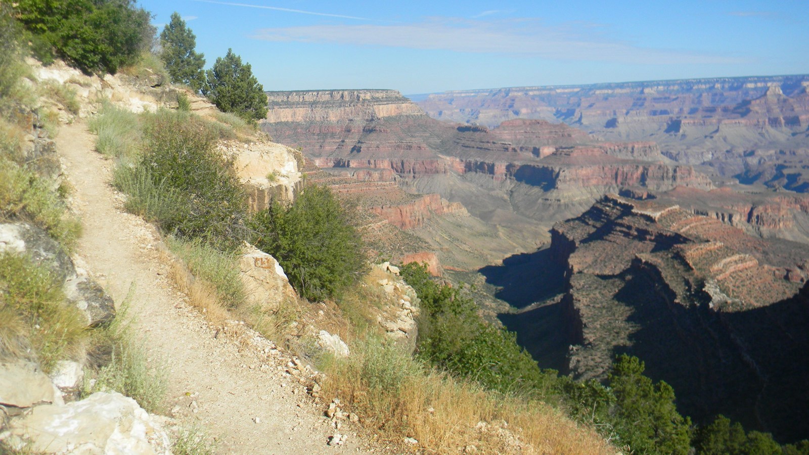
Grandview Trail
NPS/Joel Kane
Quick Facts
Location:
Desert View Drive
Amenities
4 listed
Information, Information Kiosk/Bulletin Board, Scenic View/Photo Spot, Trailhead
First used by Native Americans who gathered mineral paints on Horseshoe Mesa and later by copper miners, the Grandview Trail is a rocky, exposed, strenuous trail requiring experience and caution. Big steps and extreme pitches intensify this hike.
For experienced desert hikers only.
A stop to consult with park rangers at the Backcountry Information Center is highly recommended before attempting a hike down this trail. Hikers should carry a map and have a detailed plan before entering Grand Canyon's backcountry.
No drinking water is available on the trail to Horseshoe Mesa; springs below the mesa are not reliable . Consult with rangers at the Backcountry Information Center for the most recent updates on water availability below the rim.
Allow extra hiking time; trail conditions are more difficult than on the Bright Angel, South Kaibab, and Hermit Trails .
Trail Description
The original Grandview Trail was developed to connect the rim with copper mines on Horseshoe Mesa. The well-built trail eventually provided access to more tourists than miners, as Grandview Point provided one of the best access routes into the canyon at that time. Relatively undamaged segments of the original miner trail remain in the upper portion of Grandview Trail, testifying to the engineering prowess of the builders as they devised creative solutions to the problems that the landscape presented.
The trail descends to the right of the established Grandview Point overlook. The Kaibab/Toroweap section traverses steep slopes, and the old trail is eroded in places, so careful attention is critical. Vertical steps were placed by constructing log "cribs" that were chained or pinned to the cliff face to provide a foundation for the trail where nature provided none. The exposure along these sections impresses some hikers to the point of being considered hazardous. Unfortunately, several of the historic cribs were swept away by landslides during the winter of 2005. Trail crews restored the trail, but not the historical context of the old logs. A series of sloping ledges at the top of the Coconino Sandstone cliff demands caution, especially when icy or wet. Be careful throughout the Kaibab and Toroweap sections - a fall here could have catastrophic consequences.
The original cobblestone "riprap" trail construction remains throughout most of the Coconino section. Large slabs of sandstone placed edgewise provided a durable and labor intensive walking surface. The trail comes to the top of a dramatic east-facing gully at the contact between the Coconino Sandstone and Hermit Shale (known locally as Coconino Saddle), which offers tantalizing views into the upper valley of Hance Creek. Steep cobblestone switchbacks below Coconino Saddle descend through the Hermit Shale to the Supai Formation, where the steepness of the trail lessens as it begins a more gradual traverse out into the canyon and down to Horseshoe Mesa.
Along the trail, you might notice what appears to be trash or remnants of past mining operations, including rusty cans, nails, tools and structures. These objects are actually protected as archaeological resources. Please leave these objects as you found them, where you found them.
Destinations
For experienced desert hikers only. There are no maintained water sources along Grandview Trail. Seasonal springs below Horseshoe Mesa may offer water (which must be treated or filtered), but are not reliable.
Coconino Saddle
Recommended summer day hike; no signs present
2.2 miles (3.5 km) roundtrip / 2-4 hours / 1,000 feet (305 m) elevation change
Horseshoe Mesa
Please be respectful of campers
6.0 miles (9.6 km) roundtrip / 6-9 hours / 2,500 feet (760 m) elevation change
Viewpoint
This point is on the very northern edge of the western arm of Horseshoe Mesa.
7.6 miles (12.2 km) roundtrip / 6-9 hours / 2,500 feet (760 m) elevation change
Page Spring
Water contains high arsenic levels
7.4 miles (11.9 km) roundtrip / 6-9 hours / 3,040 feet (925 m) elevation change
Camping
A backcountry permit is required for ANY camping below the rim of Grand Canyon. Learn more and apply online or request a permit in person at the Backcountry Information Center.
Backpackers camping on Horseshoe Mesa (BF5) must camp in designated sites. Three (3) small group sites are located east of the standing masonry structure. The large group site is further north and east of the little butte that caps Horseshoe Mesa. Vault toilet facilities are located at both areas. Camping is not allowed in or near historic mines and structures. Camping in the Cottonwood (BG9) and Hance Creek (BE9) use areas is "at-large". All hikers should bring animal-proof food containers; mice and ravens are skilled at opening and looting packs or bags in this area.
Hike Smart
Every year, this trail bears witness to accidents resulting in serious injury or death. Grandview Trail is steep, rarely maintained, and does not provide access to the Colorado River. It is not a recommended first hike into the canyon.
Old decomposing mines are inherently unsafe. For your safety and the protection of local bat populations, all historic mines are closed to visitation. You may see artifacts scattered about-these are protected by federal antiquities laws.
The Cave of the Domes is closed to protect roosting bats and other sensitive cave resources. Bats are particularly sensitive to human disturbance and will abandon roost sites. Permits are required to enter caves in Grand Canyon National Park due to the extremely sensitive nature of the cultural and natural resources inside. Contact the Backcountry Information Center for information.
Make a Plan
Once you have researched your trip and are confident in what to expect on the trail, communicate your plan to someone who will notice if you are overdue and report it to 911.
Check the Weather
Summer temperatures in the shade routinely pass 100°F (38°C). Avoid hiking between 10:00 am and 4:00 pm, the hottest times of day.
From July to September, monsoons can build large, violent lightning storms. Seek shelter immediately.
In winter and early spring, temperatures can drop below 32°F (0°C) and upper portions of this steep trail become dangerously icy. Hard ice often conceals potentially hazardous passages. Over-the-shoe traction devices are highly recommended.
Pack Properly
It is critical to determine before your hike your needs for fluids and for snacks high in calories and salts. Consuming twice as many calories as during normal exercise is realistic for summer canyon hikes. The hike out of the canyon will likely take twice as long as the hike down. Wearing sun hats and cool, wet clothing will help regulate your core body temperature during warmer hikes.
Energy Balance
Your body needs energy-balancing proper nutrition and hydration are critical to your hiking success! Eat and drink while resting-sip fluids only when thirsty.
Too little water leads to dehydration and heat stroke. Excessive hydration and insufficient salt intake causes hyponatremia, a seizure-producing electrolyte disorder. If you do not feel well: seek shade, get wet, cool off, eat, and rest. Turning around may be your best option.
Suggested Maps
7.5 Minute Cape Royal and Grandview Point Quads (USGS)
Sky Terrain Trails Map, Grand Canyon (Sky Terrain)
Trails Illustrated Map, Grand Canyon National Park (National Geographic)