Last updated: October 20, 2023
Place
Geology Tour - Welcome

Historical/Interpretive Information/Exhibits
Hi, this is Greg Stock, Yosemite's park geologist. I'd like to share some fun facts about Yosemite's geology that I hope will increase your appreciation for the natural beauty all around you.
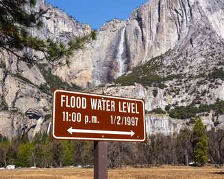
Let's begin by observing the sign before you that shows the floodwater level on January 2, 1997. The horizontal line on that sign marks the height of water during the largest and most damaging flood in Yosemite's recorded history. In your mind, extend that line across the valley and imagine floodwaters spread almost wall to wall. We will talk more about this flood at another stop, but let this image set the stage as we explore how natural forces shape Yosemite National Park.
