Last updated: January 12, 2024
Place
Fort Pickens Tour: Stop 1

Quick Facts
Location:
Fort Pickens, Florida
Amenities
7 listed
Accessible Sites, Benches/Seating, Bus/Shuttle Stop, Historical/Interpretive Information/Exhibits, Information - Ranger/Staff Member Present, Parking - Auto, Scenic View/Photo Spot
Sally Port
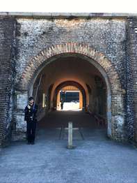
You are standing inside a covered walkway called a sally port. A sally port served as the main path into and out of a fort like Fort Pickens.To enter Fort Pickens in the early 1800s, soldiers marched across a wooden bridge.
The bridge stretched 180 feet over a dry ditch. When they reached the sally port, soldiers found several sets of heavy wooden doors. Now missing, these wooden doors allowed soldiers to control access to the fort.
The Army changed the sally port in the late 1800s. In 1896, work crews began laying railroad tracks on Santa Rosa Island. Workers used the railroad to move building materials. Soldiers used the railroad to move weapons, ammunition, and supplies around the post.
To help build Battery Pensacola, the Army ran railroad tracks from a dock on Pensacola Bay. The tracks passed through the sally port and ran to the middle of Fort Pickens. Deep, narrow grooves cut into the granite are one trace of the old railroad.
Turn left to begin your self guided tour.
