Last updated: February 1, 2021
Place
Farview Point
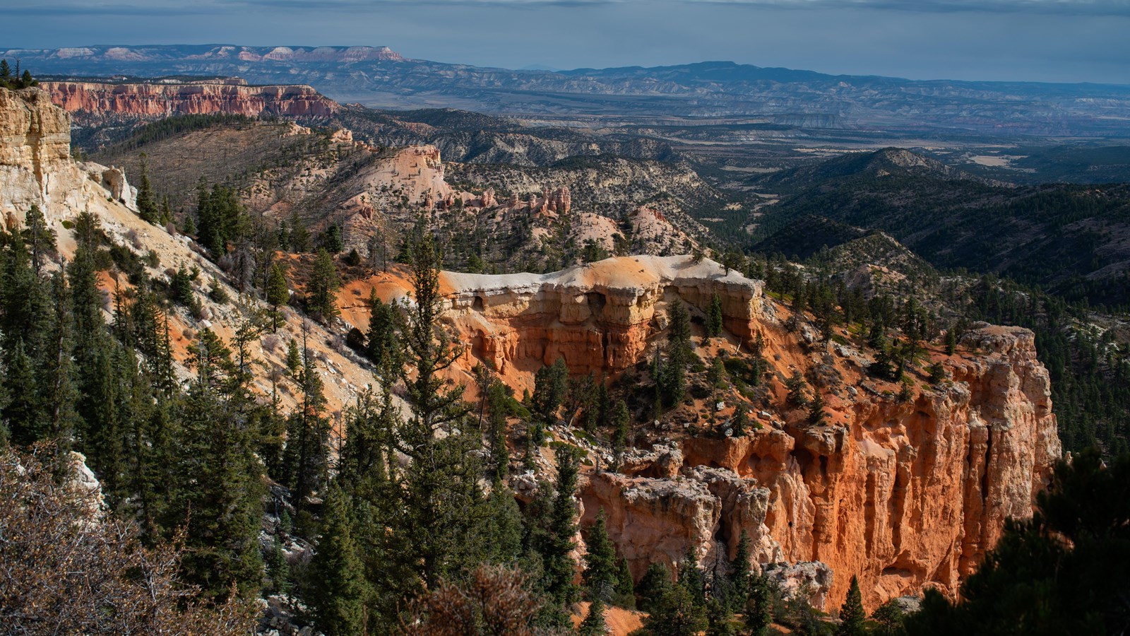
NPS Photo / Peter Densmore
Quick Facts
Location:
Mile 10.25 of the 18 mile Southern Scenic Drive
Significance:
One of 9 viewpoints along the Southern Scenic Drive
Amenities
4 listed
Recycling, Restroom, Trash/Litter Receptacles, Wheelchair Accessible
Farview Point is appropriately named. Navajo Mountain, 90 miles away on the border of Utah and Arizona, can be seen on all but the worst days. To the east, beyond the Table Cliff plateau, you may be able to see the more pointed peaks of the Henry Mountains, 84 miles away. These magnificent views result from Bryce Canyon's extremely high air quality. While many visitors are awed by the beautiful things they see here, it is what they don't see (the haze and smog produced by particulates in the air) that is one of Bryce Canyon's most valued assets.
Trails
A very short (.15 mi / .24 km) and flat but unpaved trail leads north from the parking lot to Piracy Point.
Landscape Features
To the South
See the hoodoos eroded from the edge of the Paunsaugunt plateau. From this point along the plateau you can begin to see the Rainbow Point amphitheater. A forest floor of pine and fir lies 1,000 feet (305 m) below.
To the Southeast
Navajo Mountain looms on the distant horizon over 80 miles (129 km) away near Page, Arizona. Called a laccolith, Navajo Mountain can be thought of as a volcano that never quite happened. As the Colorado Plateau was uplifted over the last 20 million years, a plume of molten rock moved upward from deep inside the Earth causing a swelling much like a large blister. Unlike a volcano, Navajo Mountain never blew its top and so the plume cooled slowly, creating the hard core of the mountain that still exists today.
To the East
The Paria Valley and the upper steps of the Grand Staircase exposed within it present most of the view. Across the valley, the Table Cliff plateau stands at 10,000 feet (3048 m) and is composed of the same Claron formation (or "Pink Cliffs") as Bryce Canyon's hoodoos. This difference in elevation is due to the presence of the Paunsaugunt fault--a major normal fault that runs northeast to southwest along the park's eastern boundary. Uplift of the Colorado Plateau over the last 20 million years is responsible for the nearly 2,000 feet (607 m) of elevation difference expressed by this fault. Following the horizon line from the Table Cliff plateau's southernmost tip (known as Powell Point), Canaan Peak is the next prominence to the south. It too is capped with the Claron formation. Further along, the horizon line reveals the top of the Kaiparowits plateau, composed of transitional Cretaceous sandstones of the Grey Cliffs. Down in the valley, the shale-rich badlands of the Grey Cliffs are largely obscured by the pinyon pine and juniper forests that grow readily upon them. Lower down, the Grey Cliffs slowly transform to the sometimes iron-rich sandstones of the upper White Cliffs. Kodachrome State Park is located in this transition zone. Beyond these are deep canyons carved into the sandstones of the White Cliffs, which are also beautifully exposed at Zion National Park further west. Note the feature known as "Molly's Nipple", which appears like a conical mountain among the White Cliffs. This is not a dormant volcano, but instead an area capped with a more erosion-resistant form of sandstone.
Almost the same distance to Navajo Mountain in the southeast, the Henry Mountains can be seen on days with good air quality, 86 miles (138 km) away beyond the eastern horizon. Like Navajo Mountain, these too are laccoliths--or plumes of molten rock that warped the rocks above them, but never broke through as a volcano would. As with the terrain of Capitol Reef National Park, which lies just in front of these peaks, millions of years of erosion have now occurred, and at the Henry Mountains it has removed the overlying rock and exposed the hard igneous cores within these mountains.
To the North
Observe the eroded edge of the Paunsaugunt Plateau, punctuated by bowl-shaped amphitheaters. Atop the Markagunt plateau to the northwest the Tushar Mountains, and atop the Paunsaugunt plateau in the north the Sevier plateau (or Black Mountains) can be seen. These were created through volcanic activity associated with the uplift of the Colorado Plateau.
To the West
The rolling ponderosa forest of the Paunsaugunt plateau is deeply incised here by water travelling north to the Tropic Reservoir. The direction of flow is decided by the plateau's upward tilt to the south and has created a rain divide between the Great Basin of Nevada and the Colorado River that follows the edge of this plateau. This elevation is the transitional zone between Ponderosa Pine Forests and Mixed Conifer forest. Watch for representatives of both plant and animal communities. Here you might find flowers such as Showy Goldeneye and Shrubby Cinquefoil. Also watch for Osprey. If you are surprised to find fish eaters like Osprey living in a desert-like environment you're not the only one. Not too far from here nest a pair of Osprey that catch and carry fish from Tropic Reservoir - a distance of two air miles!
Nature
California Condors
With a wingspan of 9 to 10 feet, the California condor is the largest land bird in North America. 10,000 years ago, its range was similarly broad--stretching across most of the continent. Much later, as European settlers began to arrive on this continent, you would've found them throughout the west, nesting in cliffs as far south as Baja California, as far north as British Columbia, and in cliffs like those below you. But by 1940, lead bullet poisoning of carrion they fed upon, poaching, DDT contamination, and habitat destruction all led to a collapse of their range to just the coastal mountains of southern California. By 1982 only 23 of these birds survived, and by 1987 all remaining wild condors were relocated into captive breeding programs.
Captive breeding programs have been successful so far in saving this impressive bird from extinction--in Zion National Park, chick #1,000 was reared in the wild in 2019. Today there are currently almost 100 condors flying free today in northern Arizona and southern Utah thanks to the Southwest Condor Working Group and the actions of hunters voluntarily participating in lead ammunition reduction programs.
In July of 1999, two condors wearing tags 82 and 93 (large numbers affixed to bird wings for identification and tracking) were spotted perched at overlooks along the southern end of this park. Since then, sightings have been exceedingly rare if they've happened at all. That said, these birds can travel well over 100 miles a day in search of food, so as populations in areas like Zion and Vermilion Cliffs National Monument continue to grow, the chances of seeing one here at Bryce get better and better.
Read more online