Last updated: October 10, 2024
Place
Bryce Point
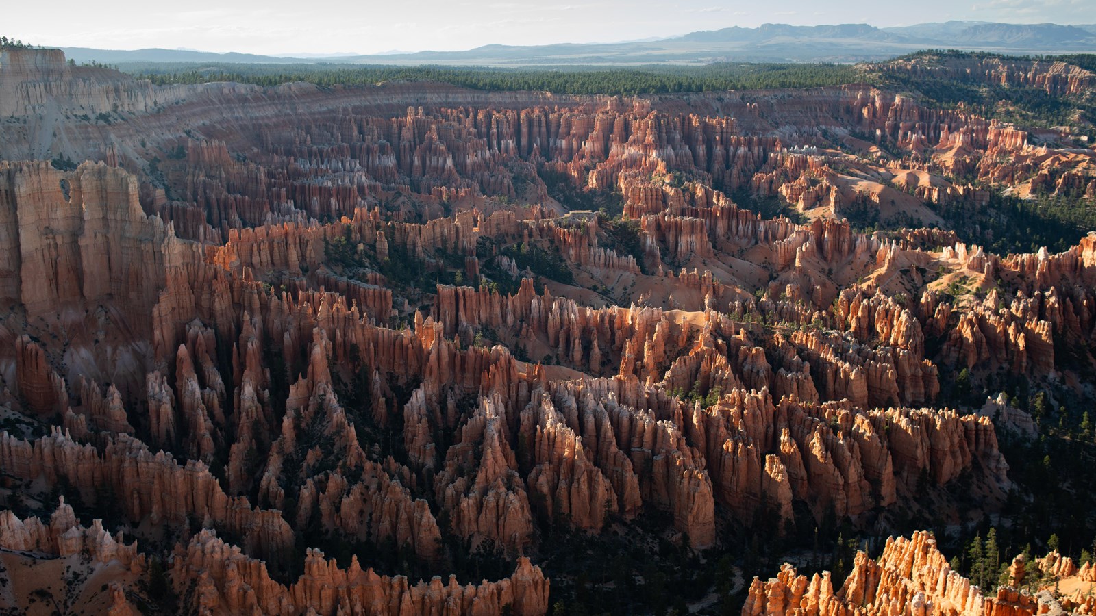
NPS Photo / Peter Densmore
Quick Facts
Location:
Turn left at Mile 3 of the Main Park Road and travel 2 miles up a spur road to this view.
Significance:
The southernmost view of the Bryce Amphitheater area of the park.
Amenities
4 listed
Bus/Shuttle Stop, Recycling, Trash/Litter Receptacles, Wheelchair Accessible
Perhaps the most iconic of the park's viewpoints, Bryce Point provides a soaring view of the Bryce Amphitheater from the south. Southern Paiutes call this place Unka Tumpi Wun-nux Tungwatsini Xoopakichu Anax, which means "Red Rock Standing Like a Man in a Hole". These hole or bowl-shaped areas--called amphitheaters--contain the world's greatest concentration of irregular rock spires called "hoodoos". There is a Southern Paiute word for "scary" or "spirit" pronounced "oo'doo", which has been associated with this place. A sacred oral tradition of the Southern Paiute states that these hoodoos are ancient “Legend People” turned into stone by the trickster god Coyote as a punishment for bad deeds.
The view and the park share the same namesake, Ebenezer Bryce, who settled in the Paria Valley to the east in 1870. Bryce lived here for only five years, but in that time, the canyon that a timber road he built travelled into became known as "Bryce's canyon" to the people who knew him. Ebenezer Bryce was a pragmatic man, constructing roads to facilitate lumber transport and surveying the route for a 10-mile irrigation ditch from the top of the plateau to the valley that would later lead to larger, more permanent settlements.
Trails
At the north end of the parking lot, the 5.5 mile (8.9 km) Peekaboo Loop and 4.0 mile (6.4 km) Hat Shop trails descend below the rim. Both of these are strenuous hikes. Closer to the viewpoint, the 5.5 mile (8.9 km) Rim Trail has its southern beginning here--varying from easy to moderate difficulty as it connects to Inspiration, Sunset, Sunrise, and Fairyland Points. Note that the section from Bryce to Inspiration is closed in winter.
Landscape Features
To the North
Bryce Point is famous for its view to the north, across the full length of the Bryce Amphitheater. Inspiration, Sunset, and Sunrise Points can all be seen along the forested edge of the Paunsagunt plateau. Famous geologic features visible from here include the Wall of Windows near Inspiration Point, dense rows of hoodoos (irregularly eroded spires of rock) forming Silent City beside Sunset Point, and the flat top of Boat Mesa seen north of Sunrise Point. The caprock of Boat Mesa, known as the conglomerate at Boat Mesa, is the same layer you stand on now. It comprises the large boulders that have fallen just shortly below the view. This conglomerate layer is a result of a time after the fresh water lakes that deposited the colorful rocks below retreated when this area began to be uplifted by volcanic activity and eroded by streams. Evidence of massive volcanic activity that was occurring around 20 million years ago is seen in the Black Mountains further north and the Tushar Mountains seen even further off to the Northwest.
To the East
The town of Tropic can be seen in the Paria Valley nearly 3,000 feet (914 m) below. The horizon is graced with the grandeur of the Table Cliffs or Aquarius Plateau, whose notched southern end (known as Powell Point) stands 13 miles (21 km) distant. Tracing the horizon south, the next prominence is Canaan Peak, which is also crested with the colorful Claron Formation. From here, the Kaiparowits Plateau forms the horizon until it meets with Navajo Mountain, approximately 80 miles (129 km) distant and visible on clear days.
To the South
Views to the south are partially obscured by the plateau's edge, which forms the southern end of the Bryce Amphitheater area here. Below the point, the Peekaboo Loop can be seen descending north through an engineered hole in the rock.
To the West
Large cavities in the white limestone layer of the Claron formation are known as the Grottos. This white layer is formed of especially soluble limestone, and groundwater working its way from above and then laterally through this layer. Above and below the Grottos, less soluble rock limits the formation of similar features. The Wall of Windows extends as a fin from this area, essentially a continuous aspect of these features that has now been exposed on both sides and therefore erodes more quickly through frost-wedging, wind, and other weathering forces. Above the Grottos, a forest of moisture-loving Douglas Fir grows and can be enjoyed along the 1.5 mile (2.4 km) stretch of the Rim Trail connecting Bryce Point to Inspiration Point. Note this section is closed in winter due to narrow trails and snow cornices.