Last updated: June 26, 2026
Place
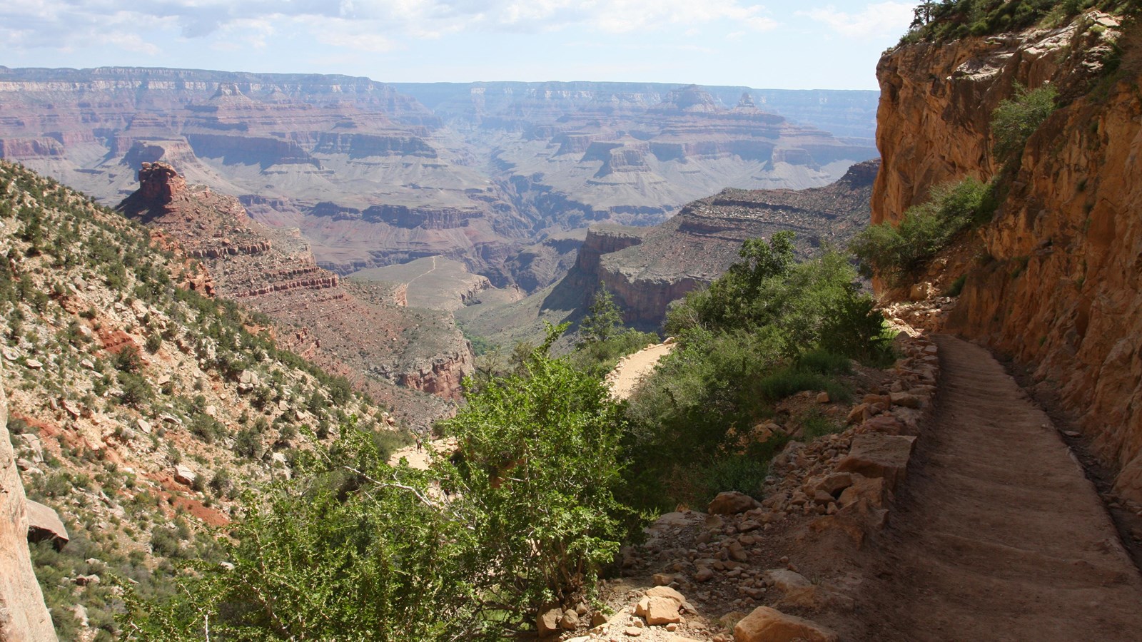
Bright Angel Trail
NPS/Ty Karlovetz
Quick Facts
Location:
Grand Canyon Village
Significance:
Corridor Trail
Amenities
6 listed
Restroom, Scenic View/Photo Spot, Toilet - Vault/Composting, Trailhead, Water - Bottle-Filling Station, Water - Drinking/Potable
The most popular hiking trail into Grand Canyon, the Bright Angel Trail lets hikers walk in the footsteps of the canyon's Indigenous peoples, miners, and early tourists, as they descend into the canyon's depths.
Offering outstanding views, morning and afternoon shade, resthouses, vault toilets, and drinking water during the summer, this trail offers an excellent first trip into the canyon.
*Note that all trails into the canyon are steep and difficult.
Where to Park
If you are not able to find a parking spot near Bright Angel Trailhead, continue driving around the Village Loop Drive to Parking Lot D — a large lot by Maswik Lodge and the Backcountry Information Center. From Lot D, it is about a 0.4 mile/0.65 km walk back to the canyon's rim and Bright Angel Trailhead.
If you park at the Visitor Center, the Village (Blue) Route shuttle will bring you to Hermit Road Interchange. From there it is just a short walk uphill to Bright Angel Trailhead.
Know Before You Go
Before heading down into the canyon, consult the signs at the trailhead, and scan the QR code for trip planning, current weather, water availability, and trail information/closures. (or visit our Key Hiking Messages webpage).
Trail Status and Future Closures
CURRENTLY OPEN : (updated June 26, 2026)
- South Kaibab Trail from the South Kaibab Trailhead to Phantom Ranch.
- The Black Bridge crossing the Colorado River.
- Tonto Trail from Tipoff to Havasupai Gardens.
- Plateau Point Trail from the Tonto Trail junction to Plateau Point.
- Bright Angel Trail from the Bright Angel Trailhead to River Resthouse.
- The River Trail east of the River Resthouse to the South Kaibab Trail junction.
- The Silver Bridge.
- The entire North Kaibab Trail.
FUTURE CLOSURES — Beginning October 15, 2026:
- North Kaibab Trail from the Redwall Bridge (approximately 2.5 miles north of Manzanita Rest Area) to the northern end of Cottonwood Campground.
- NOTE: Traditional "Rim-to-Rim" hiking (North Rim to South Rim OR South Rim to North Rim) will not be possible beginning October 15, 2026.
Bright Angel Trail - Day Hike Destinations
First Tunnel
0.1 miles (0.2 km) roundtrip / 20 minutes
Second Tunnel
1.8 miles (2.9 km) roundtrip / 1-2 hours / 590 feet (180 m) elevation change
Mile-and-a-Half Resthouse
3 miles (4.8 km) roundtrip / 2-4 hours / 1,120 feet (340 km) elevation change
Water station is on. (updated 4/13/2025)
Three-Mile Resthouse
6 miles (9.6 km) roundtrip / 4-6 hours / 2,120 feet (645 m) elevation change
Water station is on. (updated 4/13/2025)
Havasupai Gardens - Check with a park ranger before attempting as a day hike.
9 miles (14.4 km) roundtrip / 6-9 hours / 3,040 feet (925 m) elevation change
Water station is on.
Plateau Point and Trail
12 miles (19.6 km) roundtrip / 9-12 hours / 3,080 feet (940 m) elevation change
Consult a park ranger before heading down to the Colorado River. Destinations below Havasupai Gardens are not recommended day hikes due to the long distance, extreme temperature changes, and an approximately 5,000' (1,500 m) elevation change each way.
Water
Water is available seasonally (May through October) along the trail at Mile-and-a-Half Resthouse and Three-Mile Resthouse, as well as year-round at Havasupai Gardens.
However, water availability is subject to weather conditions and may be interrupted by pipeline breaks. Before you hike, check at the Visitor Center or Backcountry Information Center for water status on the trail - or visit the Key Hiking Messages webpage - or scan the QR code at the trailhead.
Even though the Bright Angel Trail has water stations along the trail, carrying your own water is still necessary. Water from natural sources such as creeks and springs should be purified. When hiking in a group, each person should be carrying water.
Trail Description
Bright Angel Trail is considered the most popular hiking trail in the park. Well-maintained and graded for stock, it is fairly easy to walk down. This can be a blessing or a curse. Wide views of the inner canyon and distant formations often distract hikers from just how far down the trail they've walked. The return hike back up and out of the canyon is far more difficult and requires much more effort. Plan for at least twice as much time back up as it took to go down.
While South Kaibab Trail follows a ridge line, Bright Angel Trail is tucked deep within a side canyon along a massive fault, which keeps the trail in this side canyon for the first few miles. The majority of the trail's elevation change takes place in the upper four miles via a series of switchbacks that seem endless. Views are framed by massive cliffs, with more plant and animal life thanks to a higher degree of shade and natural water sources. If you're interested in geology or wildlife, this is a trail with complementary features. You can expect to see mules on the trail as well. See below for more information.
The trail levels out as it approaches Havasupai Gardens, 4.5 miles (7.2 km) and over 2,000 vertical feet (925 meters) below the rim. This destination is an oasis within the canyon, home to the Havasupai People until they were forced to leave when the National Park was established. From here, you might consider the relatively flat (but very exposed) 3-mile (4.8-km) round trip hike to Plateau Point for sunrise or sunset.
Hikers interested in planning a trip beyond these destinations should consult a park ranger.
Hike Smart
Make a Plan
Once you have researched your trip and are confident in what to expect on the trail, communicate your plan to someone who will notice if you are overdue and report it to 911.
Check the Weather
Summer temperatures in the shade routinely pass 100°F (38°C). Avoid hiking between 10 am and 4 pm, the hottest times of day.
From July to September, monsoons can build large, violent lightning storms. Seek shelter immediately.
During late fall, winter, and early spring, temperatures regularly drop below freezing, and upper portions of this steep trail can become dangerously icy. Over-the-shoe traction devices are highly recommended during these times of year. Consult a park ranger for current trail conditions.
Before heading down into the canyon, consult the signs at the trailhead for trip planning and current weather, trail information and trail closures. (or visit our Key Hiking Messages webpage).
Pack Properly
Before your hike, it is critical to determine your needs for fluids and for snacks high in calories and salts. Consuming twice as many calories as during normal exercise is realistic for summer canyon hikes. The hike out of the canyon will likely take twice as long as the hike down. Wearing sun hats and cool, wet clothing will help regulate your core body temperature during warmer hikes.
Energy Balance
Your body needs energy-balancing: proper nutrition and hydration are critical to your hiking success! Eat and drink while resting, sip fluids only when thirsty.
Too little water leads to dehydration and heat stroke. Excessive hydration and insufficient salt intake causes hyponatremia—a seizure-producing, electrolyte disorder. If you do not feel well: seek shade, get wet, cool off, eat, and rest. Turning around may be your best option.
Mules and Hikers
Mules use this trail regularly.
Expect to encounter aromatic evidence of them on your hike!
Always give mules the right of way.
Encounters between hikers and mules have resulted in injuries to packers and even death to mules. To ensure safety for yourself, other trail users, mules, and mule riders, follow these steps when encountering mules on the trails:
- Step off the trail on the uphill side-away from the edge.
- Listen for and follow the directions of the wranglers.
- Remain completely quiet and stand perfectly still.
- Only return to the trail when the last mule is 50 feet (15 m) beyond your position.
Camping
A permit is required for all camping below the rim of Grand Canyon. Learn more and how to apply online, or talk with a ranger at the Backcountry Information Center, if you are visiting the South Rim.
- Only camp in designated campsites - Havasupai Gardens Campground offers 15 small group sites and 1 large group site.
- Bright Angel Campground, located on the north side of the Colorado River at Phantom Ranch, offers 30 small group sites and 2 large group sites.