Last updated: October 10, 2024
Place
Black Birch Canyon
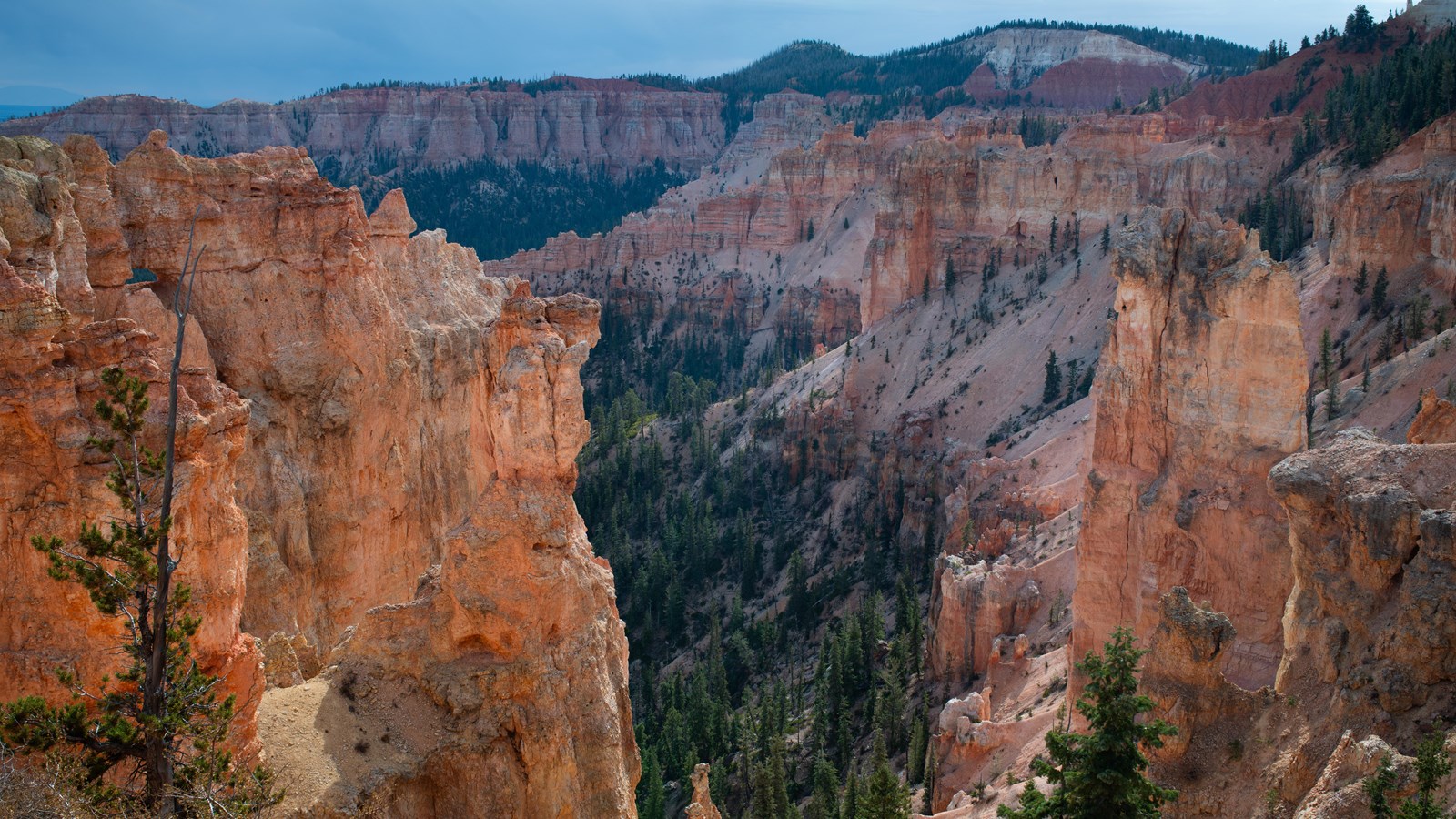
NPS Photo / Peter Densmore
Quick Facts
Location:
Mile 16.5 of the 18-mile Scenic Southern Drive
Significance:
One of 9 viewpoints along the Southern Scenic Drive
Amenities
1 listed
Wheelchair Accessible
The park has its share of misnomers (Mossy Cave isn't a cave, the canyon isn't really a canyon...) and Black Birch Canyon would be another. Since black birch (Betula lenta) only occurs in the east, it's likely quaking aspen (Populus tremuloides) were mistaken for these. Birch are famous for having bark that peels back like paper; aspen bark does not peel. Whereas aspen leaves are perfectly flat, birch leaves are slightly "V" shaped and more elongated than Quaking Aspen leaves.
Trails
No trails depart from this area.
Landscape Features
To the South
See the hoodoos eroded from the edge of the Paunsaugunt plateau contained within a bowl-shaped amphitheater shared with Rainbow Point. A forest floor of pine and fir lies 1,000 feet (305 m) below.
To the Southeast
Navajo Mountain looms on the distant horizon over 80 miles (129 km) away near Page, Arizona. Called a laccolith, Navajo Mountain can be thought of as a volcano that never quite happened. As the Colorado Plateau was uplifted over the last 20 million years, a plume of molten rock moved upward from deep inside the Earth causing a swelling much like a large blister. Unlike a volcano, Navajo Mountain never blew its top and so the plume cooled slowly, creating the hard core of the mountain that still exists today.
To the East
The Paria Valley and the upper steps of the Grand Staircase exposed within it present most of the view. Across the valley, the Table Cliff plateau stands at 10,000 feet (3048 m) and is composed of the same Claron formation (or "Pink Cliffs") as Bryce Canyon's hoodoos. This difference in elevation is due to the presence of the Paunsaugunt fault--a major normal fault that runs northeast to southwest along the park's eastern boundary. Uplift of the Colorado Plateau over the last 20 million years is responsible for the nearly 2,000 feet (607 m) of elevation difference expressed by this fault. Below these Pink Cliffs, observe the shale-rich badlands of the Grey Cliffs slowly transform to the sometimes iron-rich sandstones of the upper White Cliffs. Kodachrome State Park is located in this transition zone.
Almost the same distance to Navajo Mountain in the southeast, the Henry Mountains can be seen on days with good air quality, 86 miles (138 km) away beyond the eastern horizon. Like Navajo Mountain, these too are laccoliths--or plumes of molten rock that warped the rocks above them, but never broke through as a volcano would. As with the terrain of Capitol Reef National Park, which lies just in front of these peaks, millions of years of erosion have now occurred, and at the Henry Mountains it has removed the overlying rock and exposed the hard igneous cores within these mountains.
To the North
Observe the eroded edge of the Paunsaugunt Plateau, punctuated by bowl-shaped amphitheaters. Atop the Markagunt plateau to the northwest and the Paunsaugunt plateau in the north, the Tushar Mountains and Sevier plateau (or Black Mountains) can be seen. These were created through volcanic activity associated with the uplift of the Colorado Plateau.
To the West
The rolling ponderosa forest of the Paunsaugunt plateau is deeply incised here by water travelling north to the Tropic Reservoir. The direction of flow is decided by the plateau's upward tilt to the south and has created a rain divide between the Great Basin of Nevada and the Colorado River that follows the edge of this plateau.