Last updated: March 24, 2021
Place
7 - Original "Wasteland" Filled

WAYSIDE PANEL TITLE: Original "Wasteland" Filled
PANEL DESCRIPTION: The wayside faces north, on the northern side of the boardwalk.
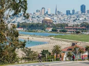
VIEW FROM WAYSIDE: The wayside, located on a boardwalk bridge looks out over the tidal marsh, a habitat for birds and other species with a fluctuating water level. Beyond the marsh are sand dunes butting up against the waters of the San Francisco Bay, and further north, the Golden Gate Bridge in front of the Marin Headlands.
TEXT: This recreated tidal marsh and lagoon recoup a fragment of a luxuriant 130-acre marsh system that once stretched along this shoreline. Abounding in life, the marsh offered the native Yelamu people an ideal place for fishing, hunting and gathering. The U.S. military regarded it as an unhealthy wasteland and dumped the Presidio's trash into this rich estuary before it was filled for the 1915 Panama-Pacific International Exposition. The Army developed Crissy airfield several years later and used the site for housing and industrial operations until transferring it to the National Park Service in 1994.
DESCRIPTION OF MAP: A black and white map in the bottom left corner depicting Crissy Field and the San Francisco Bay to the north, at the top of the illustration. On land, many paths cut east to west, paralleling the shoreline. It also shows a large and elaborate body of water that feeds into the bay. This map shows the extent of the original Crissy Field marsh in 1870.
IMAGE LOCATION: At the top center of the panel are two black and white photographs, one on top of the other.
DESCRIPTION OF IMAGE #1: The top-most photo shows a sandy, low-lying area with a very low water level. In the foreground, a pile of wood can be seen, and in the distance, a row of buildings.
CAPTION: The original marsh here was considered worthless for military purposes. The Army used the wetland as a dump and later paved over and built on much of it after the marsh was filled.
DESCRIPTION OF IMAGE #2: A section of muddy, land with areas inundated by water. In the foreground is a building with an angled roof and in the distance, a larger building along a coast, surrounded in low-lying water. To the left of the frame, a ship sits just off the coast.
CAPTION: An ocean-going dredge pumped sand and mud from the bottom of San Francisco Bay into the salt marsh in 1912 as the first step in construction of the Panama-Pacific International Exposition.
TEXT: "Wastelands" No Longer. Like wetlands everywhere, Bay Area tidal marshes for years were viewed as wastelands best suited for dumping, diking, draining and filling. More than 90% of the bay's 200,00 acres of perimeter wetlands were lost to urban growth by the early 1960s. As people began to recognize the ecological values of marshes, lawmakers passed laws to protect California wetlands and require replacement of wetlands damaged or destroyed by development. About 11,000 acres of wetlands around the Bay Area were restored or enhanced between 1995 and 2000; an additional 60,000 acres is the goal for the ensuing three decades.
MAP: The panel features a map of the San Francisco Bay to the south, and San Pablo Bay to the north. To the west, the bays feed into the Pacific Ocean through the narrow Golden Gate separating the peninsula containing San Francisco, and the Marin Headlands to the north. Areas within the bays are marked with different shades of blue; a lighter blue represents areas that were tidal marsh from 1770-1820. The darker blue shows modern day tidal marsh habitat. Areas to the south of San Francisco Bay are the marshiest now, in San Pablo Bay, the same is true for areas to the north.
CAPTION: Over about two centuries, people converted many acres of wetlands around San Francisco Bay to other uses.
DIRECTIONS TO NEXT WAYSIDE: Turn right from the wayside and go back the way you came. When you pass through the gate, turn left and take the path as it curves around the marsh to the north west about 150 feet until you reach a wayside to the left of the path.
