Last updated: March 24, 2021
Place
21 - A Tidal-Marsh Extravaganza
WAYSIDE PANEL TITLE: A Tidal-Marsh Extravaganza
PANEL DESCRIPTION: The wayside faces north on the northern side of the trail.
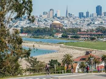
VIEW FROM WAYSIDE: The wayside is on the inland side of the San Francisco Bay Trail, on the south west corner of the tidal-marsh. A rope fence runs through wooden posts along the edge of the trail, separating it from thick coastal scrub growing long along the ground. Further back, you can see the a row of willows with slender oval leaves, a light shade of green, all of which surround the bright blue waters of the Crissy Field marsh.
TEXT: A Model of Diversity and Richness. Wetlands swarm with life and produce more food per square inch than the richest California farmland. Their complex food webs are based on detritus, the decaying remains of dead plants, rather than on living green plants as in terrestrial ecosystems. Flooded by bay tides twice daily, salt marshes serve as nurseries for countless marine fish and invertebrates, many of them food sources for people. Wetlands offer shelter, breeding habitat and abundant food for an array of animals, from microscopic plankton to large animals. Tidal estuaries also filter out pollutants and prevent flooding by capturing storm runoff.
DESCRIPTION OF ILLUSTRATION #1: An illustration of 6 different marsh plants growing in a sand dune near water.
PLANT #1: The first plant is the tallest, with long, thin green leaves and wispy, wheat-like tops. It's labeled "cordgrass."
PLANT #2: Next on the dune are three green stalks growing vertically, with smaller stalks stemming from the main one. The tops droop slightly. The plant is labeled, "pickleweed."
PLANT #3: Following the pickleweed is a rendering of arrow grass, which has several green, vertical tendrils that grow halfway up the plant, around a taller center stalk.
PLANT #4: To the right of the arrow grass is a plant that creeps along the surface of the dune, Jaumea. With little yellow flowers and alternating little leaves, Jaumea grows more horizontally than the other examples of dune plants.
PLANT #5: To the right of the Jaumea is a rendering of salt grass. These two plants share a certain resemblance. Both have yellow flowers and thin leaves that alternate up the stalk. Salt grass, however, has more of a vertical structure.
PLANT #6: The last image is of a plant with many oval-shaped green leaves at its base, and and many forking stalks with blue blossoms at their tips. It resembles a miniature tree, with many branches. It's labeled "sea lavender."
CAPTION: Salt-marsh plants tend to grow in distinct bands parallel to the shoreline. Tide levels determine soil salinity and how long plants are submerged, thus defining where each species can grow. A mere inch or two of elevation can make a significant difference in the vegetation mosaic. Marsh plants grown in park nurseries from seeds collected in six neighboring wetlands were planted in and around the Crissy Field marsh.
DESCRIPTION OF IMAGE #1: A photograph of tall, thin stalks growing thickly in a marsh. The stalks are a healthy, dark green.
CAPTION: California cordgrass, common in salt marshes, excretes excess salt that crystallizes on its leaves. Because cordgrass grows in waterlogged, oxygen-deprived mud, its stems, containing specialized tissue, transport oxygen to the roots.
DESCRIPTION OF #2: Photograph close up of a marsh plant, only this one has a brown and white patch of dead and dying stalks, which are shorter and resemble elk antlers, with small, branching sections coming off a main stem.
CAPTION: The succulent tissues of pickleweed maintain an internal salt level equal to that of the surrounding soil or water. The plant absorbs freshwater and concentrates excess salt in the tips of its fleshy leaves.
TEXT: Build it and They Will Come. The Crissy Field tidal marsh and lagoon restore vital natural habitat and ecological diversity within an urban setting. Birds began frequenting the site even before the marsh was fully excavated. Opening the marsh channel in 1999 brought together bay saltwater with freshwater runoff, attracting yet more birds in dramatic numbers and variety, some for the first time in almost a century. The calm waters and dense foliage of the fully evolved wetland will offer a feeding and roosting refuge for both resident bird species and migrants on the Pacific flyway.
DESCRIPTION OF ILLUSTRATION #2: On the far right of the panel is an illustration of the American continents, with an icon of a flying bird running the length of the West Coast, the southern tip of Argentina up to Alaska.
CAPTION: Every spring and fall about 11 million birds of more than 100 species migrate along the Pacific coast to or through the Bay Area. Nearly three-fourths of them rest and feed in the region's tidal marshes, many for the entire winter. Sanderlings, for example, nest on the Arctic tundra and winter as far south as Tierra del Fuego. They linger at Crissy Field to feed and rest during their migratory flights of up to 15,000 miles.
DIRECTIONS TO NEXT WAYSIDE: Walk east just over one tenth of a mile to reach the next wayside, located on the northern side of the trail.