Last updated: March 3, 2021
Place
16 - Shaping the Bay

WAYSIDE PANEL TITLE: Shaping the Bay
PANEL DESCRIPTION: The wayside faces north, on the northern side of the trail.
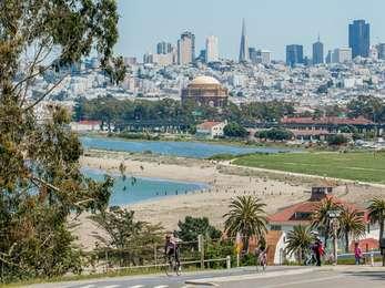
VIEW FROM THE WAYSIDE: Facing north out over the bay, you can see the Marin Headlands. To your left is Torpedo Wharf, a wooden L-shaped pier, and the Golden Gate Bridge. To the right, you can see a partial cityscape of San Francisco and Crissy Field. Behind you on a raised, grassy field, are picnic tables, and trash cans lining the far edge of the trail.
From here, you have a view of the waterfront trail and a sandy beach along the San Francisco Bay. Medium-sized rocks line the edge of the shore. The panel sits at water level, and so, the surrounding area offers an up-close view of the water.
TEXT: The Changing Bay Area. Geologic forces have been shaping the San Francisco Bay Area landscape for 4 million years. The block of rock between the San Andreas and Hayward faults, under the bay itself is slowly sinking, and the mountains on both sides of the bay are being uplifted. Climate change and human activity have further altered the bay. The filling of wetlands has shrunk the bay's size, and human-caused silting has made it shallower. Only in narrows, such as the Golden Gate, does tidal flow maintain deep channels.
MAP DESCRIPTION: Map of the bay's underwater topography. Most of the image is a brown mass that represents depressions in the bay. Areas marked in green, on top of and surrounding the depression, indicate raised ridges.
CAPTION: Geologic structures, prior river courses and the shifting of sediments by currents are evident in the bay floor's topography.
MAP DESCRIPTION: A map with a thin, blue body of water running top to bottom with dark green coastlines on either side.
CAPTION: The present San Francisco Bay began to form only about 8,000 years ago when melting glaciers caused sea level to rise and flooded the bay floor. Movement along faults in the earth's crust causes earthquakes that shift land upwards, downwards or laterally and continually change the bay's size and shape.
TEXT: The Golden Gate's River. Cold climatic episodes within the last two million years captured ocean water in inland glaciers, lowering sea level and moving the coastline westward. Just 14,000 years ago, a glacier fed river flowed through the Golden Gate and crossed 20 miles of coastal plain before meeting the Pacific Ocean where the Farallon Islands are today. Subsequent warming has melted polar ice and raised sea level to create the largest estuary on the West Coast, San Francisco Bay.
DESCRIPTION OF IMAGE: An illustration of a brown, muscly bear walking along a rock ledge and in the background, a craggy mountain range with a river at its base.
CAPTION: The Bay Area has supported different plants and animals as conditions have changed over
millions of years.
DIRECTIONS TO NEXT STOP: Walk 355 feet west and 15 feet south to arrive at the next kiosk and wayside on the western side of the Warming Hut.
