Last updated: March 3, 2021
Place
10 - Marsh Dynamics

WAYSIDE PANEL TITLE: Marsh Dynamics
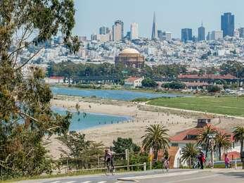
VIEW FROM WAYSIDE: This panel overlooks the Crissy Field tidal marsh. There's a fenced-off section of dune plants and coastal scrub before a sandy shore that encircles the blue waters of the marsh. On the far shore is a large white two-story building. Cypress trees and thick bushes surround the building, obscuring it somewhat from this vantage. Further in the distance, you can see the domed top of the Palace of Fine Arts. To the left, east, the trail takes you to East Beach. Right, takes you to Crissy Field, Fort Point and the Golden Gate Bridge.
TEXT: How a Coastal Wetland Works. This tidal marsh was designed and engineered to mimic a natural system. Like the dunes that front the wetland, the system thrives on natural disturbance. Freshwater and storm runoff drain from the land into the marsh, bringing sediment that settles or is flushed out to the bay. Tides continually ebb and flow, importing mineral and organic materials. Constant movement and mixing foster a biological storehouse of organisms that can tolerate fluctuations in salinity, dissolved oxygen levels, water temperature and moisture.
DESCRIPTION OF IMAGE: Three small, puffy birds on a sand dune. The birds have white underbellies and brown backs, heads and wings. Their heads are turned so that they're looking over their backs.
CAPTION: Sandpipers in winter plumage.
TEXT: The Original Mud Pie. Twice a day receding tides unveil nutrient-rich mudflats that serve up a feast to multitudes of shorebirds. Algae, fungi and decaying organic debris nurture countless invertebrates--insects, worms, crabs, clams and myriad others--that float, swim, settle to the bottom or bury themselves in the mud. This tidal menu refuels many shorebirds that stop over here during their long migration between the Arctic and South America. Though many species of shorebirds appear to eat together, their different feeding habits assure they seldom compete directly with one another for food.
DESCRIPTION OF IMAGE: Illustration of a brown and white bird with a very long, thin needle-like beak. The bird is walking in shallow water with its head down, its beak near the water's surface. It's labeled, "Marbled godwit."
CAPTION: Long-legged wading birds ply the shallows for swimming creatures or sweep or probe the muddy bottom with their slender bills for burrowed worms, mollusks and crustaceans. Similar species such as sanderlings pick up tiny prey from the exposed mud surface or just below it.
DESCRIPTION OF IMAGE: Map of the Presidio. Included is a section of the Pacific Ocean to the west, and the San Francisco Bay to the north. Also labeled is a section of the Presidio beginning at a small body of water just inland from the shore of the bay and continuing down to the southeast corner of the Presidio is Tennessee Hollow watershed.
TEXT: Freshwater laden with organic nutrients and minerals drains from the Tennessee Hollow watershed to merge with tidal inflows in the Crissy Field marsh. The mixing of freshwater with saltwater creates an estuary, a rich habitat for a diversity of plants and wildlife.
DESCRIPTION OF IMAGE: Located below the map. Yellow bulldozers in front of the reddish-brown dome of the Palace of Fine Arts. In the background, is the San Francisco skyline.
CAPTION: Construction of the Crissy Field tidal marsh in 1999 was supported by mitigation funds from the San Francisco International Airport. About 230,000 cubic yards of soil and rubble were excavated to create the marsh.
DIRECTIONS TO NEXT STOP: Walk west one fifth of a mile to reach the next wayside located on the northern side of the trail.
