Last updated: March 3, 2021
Place
1 - Headquarters
Welcome to the audio described tour of Fort Mason's waysides. Each stop on this tour describes one of the 12 waysides or kiosks within Fort Mason, Golden Gate National Recreation Area. Each stop will begin with an orientation to where you are in the park and a description of the view from the wayside. Directions to the next wayside will be detailed at the end of every stop. Please rely on these directions to find your way to the next wayside, as there are some inconsistencies in the map displayed on the app.
WAYSIDE TITLE: Headquarters
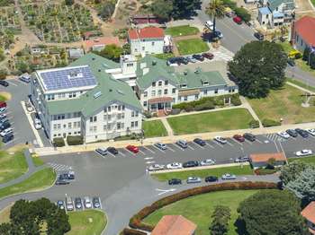
PANEL LOCATION: The wayside faces north from the sidewalk leading to the intersection of Macarthur Avenue and Franklin Street. It is at the southeast corner of Building 201 - the G G N R A and G G N P C Headquarters.
VIEW FROM WAYSIDE: The wayside stands on a small brick square and is surrounded by lawn. The brick platform is attached to the cement sidewalk. Traveling west on this sidewalk 100 feet intersects with Franklin Street. Traveling east on this sidewalk 300 feet connects to the Great Meadow. Cypress and palm trees are in the distance. The southeast corner of Building 201 is directly ahead. The large building is three-stories and cream colored with a green roof. The chapel, a white building with terracotta clay roofing, is northwest of you.
TEXT: Critical Logistics Center 1912 through 1962. Originally constructed in 1902 as an army hospital for 12 patients, this building's future was set in 1912, when the army established a major troop and cargo depot along Fort Mason's shoreline. The former hospital became headquarters for a shipping center of crucial importance during World War 2. The shipping depot, known as the San Francisco Port of Embarkation, supplied the Pacific war effort, dispatching over 1.6 million soldiers and 23 million tons of supplies in 1945 alone. Logistics directed from this modest building into the 1960 played an important role in the nation's rise to international power. Today the building serves as headquarters for another complex operation, the Golden Gate National Recreation Area, one of the most visited national park units in the country.
TEXT: How has a government presence shaped your community?
DESCRIPTION OF IMAGE: Dated 1953, A black and white photograph features over 100 soldiers wearing garrison caps and looking down from the deck of a large ship. Lifeboats are suspended above them, and a smokestack is in the background.
CAPTION: Vast numbers of soldiers shipped out for Pacific destinations from the San Francisco Port of Embarkation at Fort Mason.
DESCRIPTION OF IMAGE: Dated 1945. A large group of people parading past the facade of Building 201. In the foreground, soldiers in dress uniforms march in unison as they carry American flags. Men and women walk alongside the soldiers in the background or look on from the entrance of Building 201.
CAPTION: When the ceremonies were over, the men and women who worked in this building coordinated the movement of soldiers and supplies around the world.
DESCRIPTION OF IMAGE: Dated 1946. Five military officials walk down an outdoor staircase at Fort Mason. They are wearing Officer's Service Caps, buttoned coats, ties, slacks, and shined shoes.
CAPTION: Celebrations and ceremonies attracted high-ranking officials like General Eisenhower to Fort Mason.
TEXT: World War 2 Military Posts and Facilities.
MAP: Military posts and facilities in the San Francisco Bay Area. It depicts San Francisco, an eastern segment of Marin County, and East Bay. The map is oriented with North at the top. By quadrant, the map depicts:
Northeast Quadrant
- North of San Pablo Bay
- Mare Island Naval Shipyard
- Benicia Piers in Benicia
South of San Pablo Bay
- Port Chicago Naval Magazine in Concord
- Kaiser Shipyard in Richmond
Southeast Quadrant
- East of San Francisco Bay
- Oakland Army Base in Oakland
- Alameda Piers in Alameda
Southwest Quadrant
- South of Golden Gate Bridge
- Embarcadero in San Francisco
- Fort Mason in San Francisco
- Presidio in San Francisco
North of the Golden Gate Bridge
- Fort McDowell on Angel Island
- Fort Cronkhite in Sausalito
Northwest Quadrant
Nothing is indicated in San Rafael or in this portion of Marin County.
TEXT: The San Francisco area was critical to the World War 2 effort in the Pacific. Port of Embarkation staff managed transport operations at Fort Mason, Oakland Army Base, the Embarcadero, and piers at Alameda and Benicia. Other local facilities supported the war effort, including Kaiser Shipyards in Richmond, now the Rosie the Riveter World War 2 Home Front National Historical Park, the Mare Island Naval Shipyard and Port Chicago Naval Magazine, now a National Memorial.
DESCRIPTION OF IMAGE: A photo of the inside of a visitor center. There are various exhibits featuring text, black-and-white photos, and TV monitors.
CAPTION: Learn about World War II home front activities at the Rosie the Riveter World War 2 Home Front National Historical Park visitor center in Richmond, California.
DESCRIPTION OF IMAGE: A map of America is overlaid with photos of working women and men of the era.
CAPTION: "The Nation Mobilizes."
DIRECTIONS TO NEXT WAYSIDE: Travel west along the sidewalk 100 feet, until you are about to intersect with Franklin Street. Turn left and walk 27 feet to reach the next kiosk.