Directions

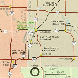
Regional map showing main highways into Pipestone, MN.
Area Map

NPS PHOTO

Plane

Commercial service - located at Sioux Falls, SD -Joe Foss Field airport. 50 miles from Pipestone National Monument. Rental cars are available at the airport.

Non-Commercial service - located at Pipestone MN airport. Courtesy car or transit service available to Pipestone National Monument from the airport.

Car

Pipestone National Monument is easily accessible from the following highways. When you reach the city of Pipestone, road signs will lead you to Pipestone National Monument.

  • I-90 Luverne, MN Exit north on US Highway 75 to Pipestone, MN - 25 miles
  • I-90 north on MN Highway 23 to Pipestone, MN - 27 miles.
  • Marshall, MN, southwest on MN Highway 23 to Pipestone, MN - 45 miles.
  • Slayton, MN, west on MN Highway 30 to Pipestone, MN - 29 miles.
  • Lake Benton, MN, south on US Highway 75 to Pipestone, MN - 19 miles.
  • I-29 north of Sioux Falls, SD to Exit 109 (Madison/Colman exit) go east on SD Hwy 34 which becomes MN Hwy 30 to Pipestone, MN - 55 miles
  • I-29 Brookings, SD exit, go east on Hwy 14 to Lake Benton, MN, south on US Highway 75 to Pipestone, MN.

There is often road construction during the summer. We suggest contacting the local DOT to get the latest construction information. [Click Here for a link to DOT]

 
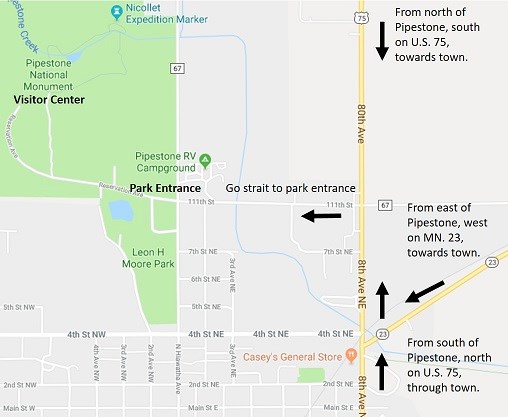
Map of North Pipestone, MN. 56164
Map of North Pipestone, MN. 56164 showing local access to Pipestone National Monument.

NPS Photo

Pipestone National Monument is located on the north side of Pipestone, Minnesota. The easiest access is from U.S. Hwy 75, which runs north & south through town. Directional signs can be found north of the MN Hwy 23 & U.S. Hwy 75 junction. The Visitor Center in approximately 1/2 mile in from the park entrance. There is ample parking for cars, buses, & RVs.

Link to Live Map
Link to Trail Map

Last updated: July 12, 2021

Park footer

Contact Info

Mailing Address:

36 Reservation Ave
Pipestone, MN 56164

Phone:

507 825-5464 x214

Contact Us