|
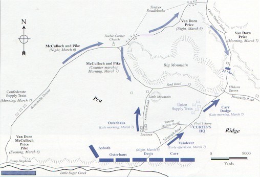
The Army of the West reached Camp Stephens, five miles from Curtis' army, on the evening of March 6. Van Dorn knew that he could not attack Curtis from the front, so he decided to make a night march around the Federal right and strike them from behind at dawn. They would use a rough trail, known as the Bentonville Detour, for the movement. The Army of the West left Camp Stephens at 8 p.m. with the Missouri State Guard in the lead. Crossing the Little Sugar Creek was slow, and the two divisions quickly became separated. To make matters worse, the Federals had barricaded the Bentonville Detour in two places, slowing the column down even more. 
Map: From National Park Civil War Series, "The Campaign for Pea Ridge" by William L.Shea Map showing the route and positions of the major units on the evening of March 6 & morning of March 7. By 8 a.m. on the morning of March 7, Van Dorn and Price reached the junction of the Bentonville Detour and the Telegraph Road, securely in Curtis' rear. McCulloch’s Division, though, was still on the Bentonville Detour five miles behind. Due to the Federal barricades, the Bentonville Detour became clogged with men, animals and artillery and, as a result, McCulloch's men were unable to cross the creek until late in the morning. To make up time, Van Dorn ordered McCulloch to march east along the Ford Road, to the front of Pea Ridge. |
Last updated: January 4, 2025
