Submerged Cultural Resources Study:
USS Arizona and Pearl Harbor National Historic Landmark

|
USS ARIZONA MEMORIAL Submerged Cultural Resources Study: USS Arizona and Pearl Harbor National Historic Landmark |
|
|
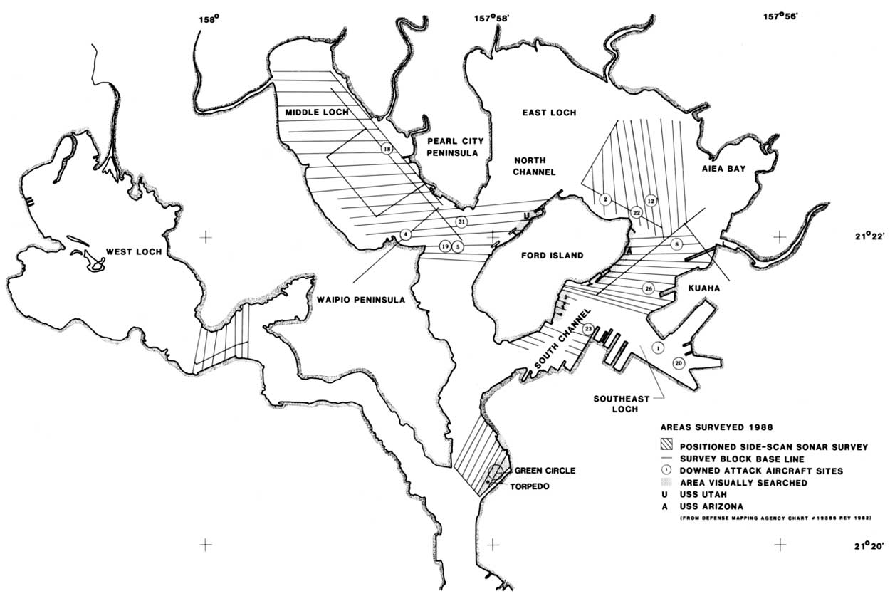
Chapter III: Archeological Record PEARL HARBOR SURVEY 1988 Results Crash-site priority was determined through historical research by NPS Park Historian Daniel Martinez. Side-scan search areas were designated around historical priority areas, Figure 3.36.
In early June prior to initiation of Project SeaMark field investigations, EOD executed side-scan surveys in five priority crash locations and an area containing materials reported by Navy divers. These areas were dived and the contacts reported: Site 2: Deep silt, no significant contacts. Divers recovered a piece of aluminum skin that was given to NPS representatives. Site 22: 100 ft. jackstay search, side-scan ineffective because of shallow depth. Located metal structure believed to be ship-related in 10 feet of water. No other contacts with diver-held sonar. Site 18: No side-scan sonar contacts. Site 4: Area of magnetic "deperm" range. No significant contacts. Area reported to have been heavily dredged and all pilings were removed. Site 12: No significant side-scan sonar contacts. "Green Circle" site: site location from Navy divers who reported WW II materials in area. Three contacts observed and located by divers: MK 14 torpedo, WW II vintage; metal chair; large hydrodynamically shaped piece of metal, possibly an MSO "pig" used for mine-sweeping. All these areas except Site 22 and Green Circle site were resurveyed as a part of the large block surveys during field operations in late June 1988. The Green Circle site area searched was expanded by MDSU divers.
EOD divers located a total of 47 contacts observed during side-scan survey operations. No materials conclusively attributable to 1941 activities were located. There were 8 negative contacts; 16 contacts were of natural origin such as ledges, rocks and tree branches; 10 were pipe, angle iron or chain. Other materials identified were: a 55-gal. drum, T-shaped piece of metal, large mass of what appeared to be dumped rubbish, a ship's electric light, a headboard shaped object, a mass of concreted materials including angle iron, flimsy 1 1/2-inch pipe, 10-foot piece of sharp iron, a locker, tapered cylindrical water tank, desk drawer, various sharp metal objects and a safe-like object. One piece of metal that appeared to be of aluminum alloy was recovered in the South Channel. This material, which was turned over to the park, is unidentified and no analysis has been conducted. Southeast Loch has been altered through post war construction. Only unpositioned sonar transects were conducted in this area with negative results.
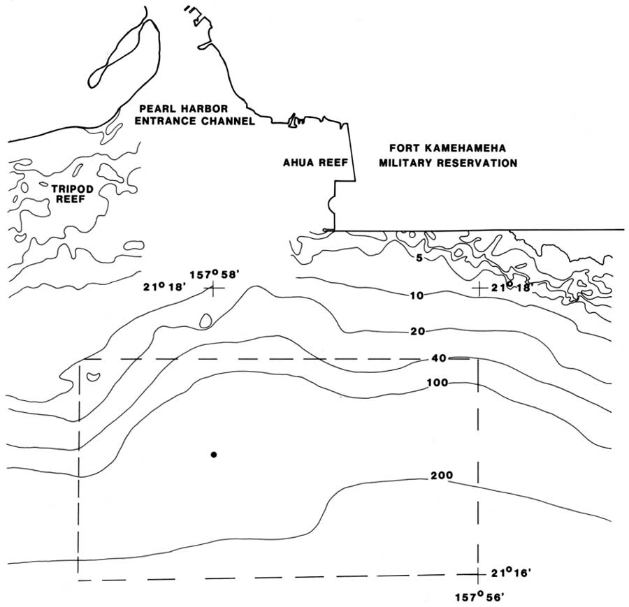
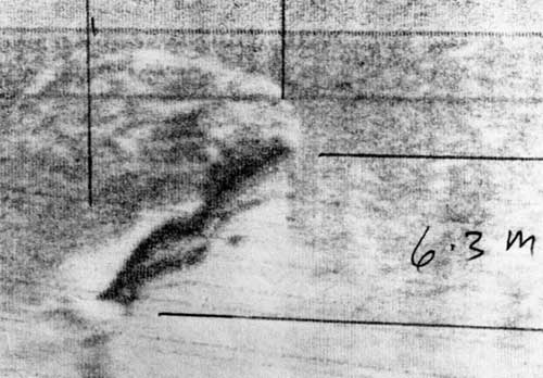
The diver visual searches were conducted primarily by MDSU, although an BOD team searched portions of the OKLAHOMA pier. Figure 3.36 depicts the area searched. Off pier 5 in 45-50 feet a metal piece and wheel or valve were found and sketched. The muzzle of a 4-inch gun was located sticking up from the bottom off shore Quay F6. Just offshore the OKLAHOMA pier behind Pier 5, large pieces of parbuckle wire were located. In the area of F-6-N a sunken barge was recorded, but little else was encountered. The area around the ARIZONA was searched but produced little not previously seen by divers during documentation dives. However, an area containing pipe, large metal pieces and a 5-foot-diameter wheel, perhaps a gear, was located just inshore of F-7-S. On the starboard side a large exfoliated plate was discovered. The plate, 12-15 feet long and 6-8 feet wide, is located about 20 feet from the stern. Near F-8-N, just offshore, some wooden pilings were discovered. Additional jackstay searches were done in the Green Circle site area extending the BOD search area. A 100-by-200-foot area was searched with negative results. Nothing larger than a 55-gallon drum was found. A section along the shore was searched with negative results. During the unpositioned side-scan surveys in the UTAH area some contacts offshore the wreck were observed. About 40 yards from the hull a 5-inch diameter pipe sticking 10 feet from the bottom was recorded by divers. About 25 yards off the bow a partly buried box or combination of reinforced plates was found. The plates, together 8-10 feet wide, protruded from the bottom about 6 feet. During survey operations on July 1, 1988, offshore the Pearl Harbor entrance within the historical defensive perimeter, a sonar contact was made that is a high probability for the Japanese submarine. The Type A Japanese Submarine had an overall length of 78 feet, beam of 6 feet 1 inch and a draft of 6 feet 1 inch (Jentschura et.al. 1977: 183), with a submerged displacement of 46 tons. The conning tower was approximately amidships (see Figures 2.44-6). The probable contact was first made during the execution of track 300 R (west to east) between event marks 10 and 11 on the record and 12 and 13 on the navigation readout at a side-scan scale of 200 meters. Water depth, taken from the chart because no fathometer was available, is 850 feet. The sea bottom appears to be hard sand with few natural objects visible above the sediment. A second view of the contact was obtained on track 320 R at a scale of 100 meters. Both records were produced at 30 lines-per-centimeter. Track 320 was run at an average speed of 4.2 knots, and track 300 at approximately 3.5-3.8 knots. Track speeds were determined by the positioning system. The contact first appeared at a scale of 200 meters on the starboard channel of the side-scan record about 8 meters (slant range) from the towed sensor. The contact is an anomalous rounded object above the sea bottom. There is an extension of the object observable in the acoustic shadow (white portion) at the approximate center line, which is consistent with target at tributes. Because of sensor proximity, the contact appears compressed on the record. The presence of crosstalk (a reflection of the contact) on the port channel indicates the contact is of a highly reflective material, most likely metal. The actual contact can be distinguished from the reflection by the presence of an acoustic shadow, which also indicates the object is above the sea bottom. The height above the bottom is computed to be 3.4 meters or 11 feet (length of shadow = 2.25m; height of fish = 24m; slant range to end of shadow = 15.75m). A second contact with the object was obtained during a ship track in the same direction as the original contact (west to east), but on a scale of 100 meters. The contact was on the starboard channel, with crosstalk also present on the port channel. The contact appeared in the center of the starboard channel and is minimally compressed. Computations were done to deter mine the object's approximate length from the signature on the sonar record. A rectangle that represented the contact's linear and cross-track dimensions was drawn on mylar and measured. The linear dimension is 2cm and the cross-track dimension is 1.8 cm, giving an overall length of the contact on the record (computed as the hypotenuse) of 2.69cm. 2.7cm was used for calculations. (Boat speed = 2.1 m/sec, 30 lines/cm, 100 m scale). The computed length of the object is 22.68m or 74 feet. The sonar contact falls well within the expected parameters for the target. Although nothing can be said for certain without visual confirmation, the contact is congruent with the sonar signature expected from a Japanese midget submarine. Another possibility is a metal-hulled small craft of similar dimensions sunk in the area. All the evidence indicates the right area, near the right depth for the target of the survey -- a Japanese Type A midget submarine. Visual confirmation either by research submarine or remotely operated vehicle is necessary for further analysis to determine whether this is the target.
http://www.nps.gov/usar/scrs/scrs3p.htm Last Updated: 27-Apr-2001 |