

|
Urban Ecology Series No. 4: The River in the City |
 |
The Decline of the River
|
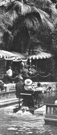
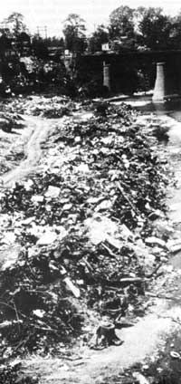
In the middle of the 18th century the United States was engaged in a large and lucrative fur trade with Europe, and most of the furs were found along the river systems of eastern North America, and later around the lakes and river systems of north central North America. The great canoe route from central Canada to Montreal traversed the lakes and some of the slow-moving rivers of southern Canada, proceeded via Lake Superior, the French, Mattawa, and Ottawa Rivers and finally to Montreal and the St. Lawrence River system, the gateway to Europe. By this route furs were carried in canoes and sailing vessels from the interior of the continent to Europe. Beaver was an extremely important item in this fur trade, and on the Ohio River in western Pennsylvania a county that borders on the State of Ohio has place names that testify to the role that beaver played in the area. The county is, of course, Beaver County. The county seat is Beaver, Beaver Falls is one of the larger towns, and the Ohio River Valley, as it runs through the county, is known as the Beaver Valley. In addition there is Beaver Creek and the Beaver River. The disappearance of the beaver from Beaver Valley is symbolic and connected with man's technological development of the river systems, rising industrialization, and change in the priorities and values associated with the river systems. All of these factors altered the river systems biologically as well as technologically and forced them to serve the needs and purposes of man. The flood plains have been occupied, the wetlands and marshes filled, the tributary streams channeled elsewhere, and the major river systems drained and dredged for flood control. The installation of locks and dams on the rivers did two things: regulated the flow of water making it independent of the season of the year, and converted the flowing rivers into what were essentially a series of flat lakes with locks that permitted the movement of barges through the various levels. Prior to the construction of locks and dams and other aids to navigation, traveling most rivers was a hazardous business. It required great skill to negotiate the rapids and similar obstacles and necessitated transfer points to go around the rapids. The Lower Mississippi, of course, still has no locks or dams to regulate its flow and from the point of view of river travel, it remains an extremely dangerous river.It has currents and eddies, it is wide and sweeps around bends at fairly high velocity, and it is prone to floods. The surface of the river is higher than the surrounding delta country, making floods a constant threat. On the Lower Mississippi, flood control is primarily a spin-off from the preventive flood control on the Upper Mississippi, the Ohio, and the Upper Missouri, although it should be noted that stabilized levees, paved river bottoms, overflow diversion channels and sluices, and hydraulic pumps on the Lower Mississippi represent an outstanding example of the engineered environment. While the rivers made transportation, exploration, and commerce possible, they also served as a water supply, a source of bulk chemical water for industrial processes. Moreover, the river served as an open sewer for the industrial and municipal wastes that resulted from the industrialization itself and from the cities that developed around it. It was a natural development that railroad rights-of-way followed the river valley. Such a procedure made for easier construction, for easier movement of materials to the construction site, and also eliminated the need for more bridges and trestles to accommodate the railroad rights-of-way across valleys. Along the Upper Mississippi, railroad rights-of-way occupy both banks and obstruct from view and use one of the most scenic rivers in the United States. This must be viewed as an outmoded way of locating highspeed rail transportation. The interstate highway program has demonstrated that roads and bridges, and by extension, railroad tracks, can be built economically by taking the shortest distance between two points. Thought should be given to the possibility of opening up the shoreline of rivers for recreational development by rerouting some railroads and combining them with highways in common transportation corridors. In a technological age this should not be an insurmountable task. Moreover, the relocation of railroads away from the river valleys might induce some heavy industry to follow this example and thus free additional land adjacent to rivers for alternative development. The great cities that were built along rivers in order to take advantage of their transportation potential, their water supply, and as a means of disposal of wastes altered the character of the rivers from a wild, untamed state to floating garbage pails, rendering them unfit for human use and destroying wildlife habitat. In the early days of exploration and expansion, there were sound reasons for locating cities on the coast at good harbors, at the confluence of rivers, or at other river locations where water power and water transportation were available. This is true of Boston on the Charles River; Minneapolis-St. Paul near the confluence of the Mississippi and Minnesota Rivers; and Philadelphia on the Schuykill and the Delaware. Springfield and Hartford are two cities strung like beads on the Connecticut River, while New York has the picturesque Hudson, the Harlem, and the East Rivers. The Ohio starts at Pittsburgh as the confluence of the Allegheny and the Monongahela Rivers and runs through the industrial heartland of Pennsylvania, West Virginia, Ohio, and Kentucky. In its first 50 miles the Ohio passes through Mckees Rocks, Bellevue, Ben Avon, Avalon, Corapolis, Sewickley, Leetsdale, Ambridge, Aliquippa, Baden, Conway, Freedom, Monaca, Rochester, Beaver, Vanport, Midland, East Liverpool, Wellsville, Empire, Toronto, Winton, Steubenville, Mingo Junction, Follansbee, Brilliant, Wellsburg, and Wheeling. From West Virginia the Ohio River runs through Marietta, Parkersburg, Huntington, Portsmouth, Cincinnati, Covington, Lexington, Evansville, Paducah, and Cairo, at the confluence of the Ohio and the Mississippi. Similar lists of towns could be made for the Mississippi-Missouri Rivers which drain the heart of the continent; the Platte of the high plains; the Potomac and Susquehanna flowing through the mid-Atlantic states to Chesapeake Bay; the Connecticut running south through New England; the Hudson River in New York; the Tallapoosa and the Coosa running through Alabama; and the Rio Grande in the Southwest, forming our common boundary with Mexico. All these rivers and many more were the transportation corridors of the developing continent and also the lifeblood and source of prosperity for the cities, towns, and villages that were established on the shores and at the confluences. Industrial development in the United States followed the pattern of water power development and transportation facilities. The industrial development of New England, with its small factories located on streams that were essential to the water power in use in the late 18th and early 19th century, contrasts sharply with the large industrial developments that occurred further inland, but the principle is the same. Here steel mills and other heavy industry occupied vast flood plains and the rivers served as avenues of transportation for goods to the consumer and of coal to the coal-burning, steam-generating power plants that, in turn, supplied the electrical energy necessary to power the industries. The Ohio, the Upper Mississippi, the Missouri, the Kanawa, the Chicago, and many other rivers were essential to the development of natural resources and to the manufacture of goods of every kind. As a result, they were regarded as convenient adjuncts to the industrialization process and the viability of the rivers as ecosystems was ignored. When the rivers became the common method of sewage disposal as well as the main source of water supply for the cities located along their banks, chemical water treatment plants became necessary. Early water treatment was a simple mechanical filtration through beds of sand, plus chlorine for bactericidal purposes. Those cities having more advanced water treatment facilities added the refinement of a water softener in the form of salts precipitation, and in this way the city's water supply was potable as well as acceptable as a cleaning agent. This procedure treated the water as a bulk chemical and the water inlets and outlets might, and often were, in close juxtaposition to each other in the river. The standard practice was to drill wells into the river bed and to filter the water through the sand beneath the bed. The water was river water, but some filtration had taken place. Modern water treatment plants often must cope not only with the public health problems of sewage but with heavy metals such as mercury, zinc, cadmium, and lead, with acid sulfate wastes, with nitrate from agricultural fertilizer runoff, with excessive phosphates, and with a host of pollutants from the manufacturing, extracting, and agricultural industries. As a consequence of industrialization and the burgeoning population in our metropolitan areas coupled with the barest minimum in sewage treatment facilities, no major river in the United States has water that is fit to drink untreated today, and none is fit for body-contact water sports. It is hard to believe that the Chesapeake Bay, the Hudson River, and most of the Atlantic Coast once boasted salmon runs and that rivers such as the Ohio River were the habitat for pike, sturgeon, and bass. Furthermore, there was a time, difficult to imagine, when prized game fish and many of the most prized fur-bearing animals were common along the flood plains, wetlands, tributaries, and estuaries of the major river systems of the United States. in 1970, the spring runoff from the frozen agricultural uplands of Maryland and Virginia dumped unusually large quantities of nitrogen compounds into the Potomac River. The water purifying equipment could not cope with the pollutant, and a foul-tasting water supply resulted. The beneficiaries were suppliers of bottled water whose stocks were quickly exhausted. A large number of people resorted to collecting and boiling rainwater for domestic use until the quality of the faucet water was restored. Sediment is the main problem created by agricultural runoff, and the many water impoundment facilities constructed in recent years have done much to alleviate the problem. There are now some 1000 dammed watersheds that trap much of the sediment but an equal number are still needed. The Cuyahoga River in Ohio was created by the Wisconsin glaciation. It rises near Cleveland, a few miles from the shore of Lake Erie, runs southward through the town of Kent, Ohio, westward through Cuyahoga Falls, west and north through Akron, and finally back to Cleveland, where it enters Lake Erie about 30 miles from its source. At Kent, the river goes over a falls in the middle of town and flows through a series of falls to the next town, Cuyahoga Falls, and finally into Cuyahoga Gorge, which is wild and scenic. The Cuyahoga River from Kent to Cuyahoga Falls, through Cuyahoga Gorge, qualifies as a wild scenic river by any standard. As the river goes through Akron, however, it becomes an outlet for industrial wastes, and as it flows through Cleveland it becomes an open sewer for heavy industry and for the city of Cleveland. This river, which is 60 or 70 miles long, is part pristine beauty and wilderness and part polluted sewer that not long ago actually caught fire! It is ironic that New York City, one of the great cities of the world, traditionally suffers from a shortage of water, even though it is situated on the banks of the Hudson River, one of the greatest sources of freshwater on the eastern North American continent. Pollution makes it impossible to use the water from the Hudson as it flows through New York City and supplies must be brought from reservoirs miles up river to the metropolitan area. |

|

|

| History | Links to the Past | National Park Service | Search | Contact |
|
Last Modified: Wed, Mar 20 2003 10:00:00 pm PDT |