

Survey of Historic Sites and Buildings
 |
BENICIA BARRACKS AND ARSENAL California |
 |
| ||
Until inactivated in 1963 the modern Army installation known as Benicia Arsenal included what were once two separate posts, Benicia Barracks (1849-1908) and Benicia Arsenal (1851-1963). The barracks, established at the western end of Suisun Bay as an infantry base in 1849, was one of the first military posts in California. Two years later, to support troops scattered along the Pacific coast conducting exploration and combating Indians, the Army founded adjacent to the barracks an ordnance supply depot, the first in the Far West, for the Pacific Division. The next year, 1852, the depot was officially designated an arsenal. It soon had a quartermaster depot associated with it. The barracks remained a garrisoned infantry post until 1898, when its troops departed for duty in the Philippines. In 1908 the arsenal absorbed it.
 |
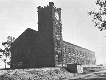
| Arsenal ("Clocktower") Building (1859), Benicia Arsenal, as it appears today. (photo Charles W. Snell, National Park Service) |
Throughout its existence the barracks-arsenal was a primary staging area and logistical support center for the Western United States and the Pacific area—in the Indian wars, Civil War, Spanish-American War, World Wars I and II, and the Korean conflict. For slightly more than 3 years during two separate periods in the 1850's Benicia was the headquarters of the Army's Department of the Pacific, before and after that time located at the Presidio of San Francisco. William T. Sherman, George Crook, and Ulysses S. Grant served at the arsenal as young lieutenants; Col. James W. Benet, father of the poets William Rose and Stephen Vincent, was commanding officer. And the Army's camel experiment in California ended at the arsenal, where the camels were assembled in 1863 and sold at public auction the next year.
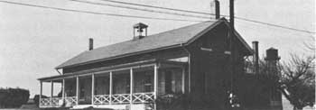
The old barracks and arsenal are both registered State historical landmarks. In 1965, or 2 years after the Army inactivated the arsenal, it conveyed the installation to the city of Benicia. The city has leased it to a corporation, which has modified some of the buildings. All of them are open to exterior inspection, but may not be entered except by permission. To facilitate a walking tour, the corporation has published a brochure on the history of the buildings. The barracks and arsenal sites are situated about one-quarter mile apart. Extant on 252 acres of the 2,200 acres that comprised the military reservation are 21 one- and two-story structures, four of frame and 17 of brick and sandstone, that were constructed between 1854 and 1884. One of these, the hospital, believed to be the first military hospital on the Pacific coast, in which Indian war casualties were treated, is at the barracks; and the remainder at the arsenal. Three other buildings date from 1900, 1909, and 1911.
Practically all the structures were used for modern arsenal purposes. They are all in excellent condition, have been little altered, and suffer only from minor intrusions. As a whole they provide an outstanding example of military architecture, especially of arsenals, in the last half of the 19th century. Buildings of historical interest, besides the hospital, include the arsenal; headquarters building; the commanding officer's quarters; various shops and warehouses, among them those that housed the camels in 1863-64; various officers' quarters; barracks; powder magazines; and guard house. Burials in the post cemetery date from the 1850's.
 |
| Hospital building, the only surviving structure from Benicia Barracks. (photo Charles W. Snell, National Park Service) |
 |
FORT BIDWELL California |
 |
| ||
Tucked into the extreme northeastern corner of California, Fort Bidwell (1865-93) was founded by Volunteer troops to protect settlers and emigrants from the Indians of northern California, southern Oregon, and western Nevada. In the 1890's the log post spread slightly to the south of its original location, and a town grew up around it. Its garrison fought with Gen. George Crook at the nearby Battle of Infernal Caverns in September 1867, during his 1866-68 Snake campaign, and in the wars against the Modocs (1872-73), Nez Perces (1877), and Bannocks (1878). The Indian Bureau succeeded the Army at the post and utilized it for a boarding school, which was operated until 1930. In that year the original two-story barracks, later a school dormitory, was razed.
All that remains, in varying states of preservation, are the stable; a school, now a private residence; a few other buildings; a graveyard; and the parade ground. The site, headquarters of the Fort Bidwell Indian Reservation and a registered State historical landmark, is marked by a monument.
 |
FORT BRAGG California |
 |
| ||
The major mission of the small garrison assigned to this coastal fort, established in 1857 on the Mendocino Indian Reservation, was control of the reservation. When the post was but a year old, its troops took part in the campaign in eastern Washington. At the beginning of the Civil War, California Volunteers replaced the Regulars and in 1864, by which time most of the Indians had departed from the reservation, abandoned it. Three years later the Government opened the lands to settlement, and the town of Fort Bragg grew up around the site.
A State marker commemorating the fort, a registered State historical landmark, is located near the hospital site, at 321 Main Street. Main Street bisects the site of the parade ground, bounded on the north by Laurel Street between Franklin and McPherson and on the south at a point about 100 feet south of Redwood Street.
 |
FORT HUMBOLDT California |
 |
| ||
This fort, active in the years 1853-67 and located on a bluff over looking Humboldt Bay and the Pacific, was the Army headquarters and logistics base for northern California and one of the few posts in the area. Lt. George Crook arrived with the first detachment, and Capt. Ulysses S. Grant served at the post during the years 1853-54. The garrison served in the second Rogue River War (1855-56), in Oregon.
Nothing remains of Fort Humboldt on the actual fort site. The only extant structure of any sort is the remodeled hospital, which has been shifted slightly from its original location. State offices now occupy it. Markers indicate officers' row. A bronze tablet on a boulder, placed by the Daughters of the American Revolution, marks the site. It is a registered State historical landmark and State historical monument.
 |
FORT JONES California |
 |
| ||
Fort Jones (1852-58), a small post in the Scott River Valley of north-central California, was founded to protect gold miners from the Indians. Two young officers who served there were Lt. George Crook and Capt. Ulysses S. Grant. The troops participated in the 1858 campaign in eastern Washington; the first (1853) and second (1855-56) Rogue River Wars, in Oregon; and the 1857 campaign against the Pit River Indians, in the northeastern part of California.
All traces of the post, originally of log and later of frame, have disappeared. A flagpole and commemorative marker, erected by Siskiyou County, indicate the site, a registered State historical landmark.
 |
FORT TEJON California |
 |
| ||
Near Tejon Pass along one of the routes running north from Los Angeles to the northern goldfields. Fort Tejon (1854-64) protected travelers and settlers; was a station on the Butterfield Overland Mail (1858-59); patrolled the area for cattle rustlers and horse thieves; served as a social and political center for a large area in central California; and controlled the Indians living on the Tejon (Sebastian) Indian Reservation. The reservation, founded in 1853 about 20 miles to the north by Edward F. Beale, Superintendent of Indian Affairs for California and Nevada (1852-56), was a governmental experiment he conceived in Indian management. It was the first of a series of small but well-defined reservations where Indians were to be concentrated and taught farming and trades so they could become self-sufficient. Beale's successors established a few other reservations, but mismanagement weakened practically all of them. The Fort Tejon Reservation was disbanded in 1863.
Meantime Fort Tejon had entered a new era in 1857 when Beale, while surveying for the Army a proposed wagon road across the Southwest, brought a 25-camel caravan from Camp Verde, Tex., to the scene of his earlier reservation experiment. The camels were later also quartered at Drum Barracks (Camp Drum), at present Wilmington, Calif., and other installations in southern California. They transported supplies between Fort Tejon and Drum Barracks, as well as between other posts. The outbreak of the Civil War and other factors ended the experiment. In 1861 the Army inactivated Fort Tejon, the camels temporarily went to other posts, and in 1863 were transported to Benicia Arsenal, Calif., and sold there the next year at public auction.
The year before, Volunteers from Camp Independence, Calif., had regarrisoned Fort Tejon to control 1,000 Indians they had removed from the Owens River Valley. By the middle of 1864, dissatisfied with conditions, most of the latter had returned to the valley. Evacuated that same year by the Army, Fort Tejon became part of the Rancho Castac and 2 years later part of Rancho El Tejon, owned by Beale, who used its buildings as residences and stables.
Fort Tejon State Historical Park is also a registered State historical landmark. It features three restored adobe buildings: a barracks, an officers' quarters, and a building that probably was an orderly's residence. Adobe ruins mark the sites of other buildings. A visitor center displays exhibits.
 |
 |
http://www.cr.nps.gov/history/online_books/soldier-brave/sitec2.htm
Last Updated: 19-Aug-2005