


Survey of Historic Sites and Buildings
  |
LOLO TRAIL Idaho-Montana |
 |
| ||
Ever a dim track through a primeval land, this trail across the Bitterroot Mountains of Idaho and Montana is in wilderness country even today. Being interpreted in conjunction with Nez Perce National Historical Park, Idaho, under a cooperative agreement between the U.S. Forest Service and the National Park Service, it is a National Historic Landmark primarily because of its relations with the Lewis and Clark Expedition (1804-6). Long before that time, however, the Nez Perce Indians followed it en route from Idaho to their buffalo hunting grounds in Montana; and in 1877 the nontreaty Nez Perces traveled over it on their eastward flight during the Nez Perce War.
The trail extended eastward across some 150 miles of rugged terrain from Weippe Prairie, Idaho, through Lolo Pass into the Bitterroot River Valley of western Montana to the junction of Lolo Creek and the Bitterroot River. For most of its distance, the trail passed along the high backbone of the mountain mass between the north fork of the Clearwater River and its middle fork the Lochsa River. Along the stream courses, cascades and rapids made the river gorges impassable, and the steep rock walls of the gorges prevented the establishment of a practical foot trail along the streams. U.S. 12, known as the Lewis and Clark Highway, parallels the route today but for the most part runs south of it.
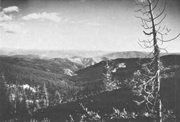 |
| View from the Lolo Trail in Idaho. (photo by Jonathan Blair, Bureau of Outdoor Recreation, Department of the Interior) |
The eastern part of the trail is in the Lolo National Forest of Idaho and the Bitterroot National Forest of Montana; its middle and western parts in Clearwater National Forest, Idaho. A dirt fire-access road constructed by the U.S. Forest Service in 1939, ordinarily suitable only for trucks and four-wheel-powered vehicles, generally follows a large portion of the trail. The road runs from the vicinity of Powell Ranger Station, on U.S. 12 about 12 miles southwest of Lolo Pass, to Pierce, Idaho. Its western portion runs north of the trail, but its central and eastern portions closely conform to it.
The trail was the traditional route of the Nez Perce Indians from their homeland along the Clearwater River, in north-central Idaho, to their buffalo hunting grounds in Montana. For this reason, the trail is sometimes known as the Nez Perce Buffalo Road. In September 1805 Lewis and Clark moved over it, the most arduous and critical portion of their 4,000-mile journey to the Pacific. Hampered by sleet and snow, dense underbrush, dangerous terrain, lack of food, and exhaustion, the men found the crossing to be a terrible ordeal. The lateness of the season threatened to strand them in the midst of the Rocky Mountains for the winter. On their return trip in June 1806 they once again followed the trail. The other dramatic incident involving it occurred in 1877, when about 700 nontreaty Nez Perces crossed it after the Battle of the Clearwater, Idaho. Resisting confinement to an Idaho reservation, they moved into Montana, pursued by Gen. Oliver O. Howard's slow-moving Army, but were finally vanquished at the Battle of Bear Paw Mountains, Mont.
The U.S. Forest Service has placed historical markers along the trail at sites associated with the Lewis and Clark Expedition and the Nez Perce War.
NHL Designation: 10/09/60
 |
 |
http://www.cr.nps.gov/history/online_books/soldier-brave/siteb5.htm
Last Updated: 19-Aug-2005