

Survey of Historic Sites and Buildings
 |
FORT GIBSON Oklahoma |
 |
| ||
Fort Gibson was one of the most important of the posts on the "Permanent Indian Frontier." The first fort established in Indian Territory, it was actively involved in the problems associated with the relocation there of the Five Civilized Tribes from the Southeast. A frontier hub of commerce and military activity, it was a key transportation point and a testing place for such newly activated organizations as the Ranger units and Dragoon Regiments.
Established in 1824 by Col. Matthew Arbuckle on the east bank of the Grand River just above its confluence with the Verdigris and Arkansas Rivers, the fort was responsible for keeping peace between the Osages, who opposed any intrusion into their territory, and the Cherokees, who were already filtering into Indian Territory. The post replaced Fort Smith, which had been too far south to control the Osages effectively and was to remain inactive, except for several months, until 1839. During the period of Indian removal, in the 1830's and 1840's, the Fort Gibson garrison helped receive, care for, settle, and enforce peace among immigrant Cherokees, Creeks, Choctaws, Seminoles, and Chickasaws, as well as attempted to protect them from the Plains Indians. Troops provided escorts for surveyors marking the boundaries of Indian lands; established other posts in Indian Territory, such as Forts Coffee and Wayne and Camp Holmes; laid out a network of military roads; and tried to control the illegal liquor traffic.
In 1834 the fort was the base for the Dragoon Expedition, originally under the command of Col. Henry Leavenworth, who died of fever en route. His successor, Col. Henry Dodge, met with some of the southern Plains tribes at the north fork of the Red River and persuaded them to send delegates to Fort Gibson for negotiations. As a result, in 1835 the tribes made their first treaties with the U.S. Government at Camp Holmes, Okla.
 |
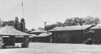
| Reconstructed Fort Gibson.(National Park Service) |
Fort Gibson was also a center of trade and travel. Located at a point beyond which river navigation was virtually impossible, it was a supply depot for a large area. Keelboats and later river steamers came up the Arkansas to the fort a few months each year, and unloaded passengers, military stores, and Indian trade goods. Traders furnished return cargoes. The Texas Road, which ran from north to south and linked the growing American settlements in Texas with the Missouri River Valley, passed by the fort, which became a way station for emigrants, freighters, and traders. The troops also provided escorts for road traffic. The fort continued to be a transportation and freighting center until the arrival in the region of the Missouri, Kansas, and Texas Railroad in 1872.
Originally a four-company post, the fort was expanded in 1831 to accommodate a regiment and it became the district headquarters, which overtaxed its limited capacity. Situated on low ground, it was also subject to flooding and threatened by malaria. In 1846 construction began of a new post on the hill overlooking the old site. But the project proceeded slowly and by 1857 only one stone building, the commissary storehouse, had been finished. That year, because the Cherokees had been requesting that the fort be evacuated and because the frontier had moved westward, the Army abandoned it and the tribe took possession.
At the outbreak of the Civil War the Confederates occupied the fort, but in 1863 Union forces made it a Federal stronghold in Indian Territory and sought to strengthen the loyal element of the Cherokees. Regular troops replaced the Volunteers in 1866 and garrisoned the post until 1890. During this period the fort on the hill was completed; it consisted of seven large stone buildings and 10 frame ones.
Although the original fort has long since disappeared, the State of Oklahoma, under a Works Progress Administration (WPA) grant, completed in 1936 on a 55-acre tract a reconstruction of the original log stockade and a number of outlying log buildings almost on the original site. Except for the use of more durable materials, especially pine timber and lime chinking, the reconstruction is faithful to the original. Interpretive markers guide the visitor. On the ridge to the east overlooking the reconstructed stockade is the second fort site. Stone buildings, some now private homes, survive in various stages of repair, together with some ruins. A two-story stone barracks, which has porches running its length on both levels, is the most imposing structure and is in good condition. Owned by the State historical society, it is a private residence. One mile east of the town of Fort Gibson is the Fort Gibson National Cemetery. Many of the soldiers buried there were removed from Oklahoma Forts Towson, Arbuckle, and Washita.
NHL Designation: 12/19/60
 |
 |
http://www.cr.nps.gov/history/online_books/soldier-brave/siteb24.htm
Last Updated: 19-Aug-2005