

Survey of Historic Sites and Buildings
 |
FORT SNELLING Minnesota |
 |
| ||
Founded in 1819, this fort was for many years the most northwesterly military base in the United States; a key bastion on the upper Mississippi; and the northern outpost on the "Permanent Indian Frontier," which extended as far south as Fort Jesup, La. The post protected settlers from Indians, cleared the way for the settlement of the old Northwest, and promoted the growth of the fur trade. Later, from 1861 until 1946, it was essentially a training installation.
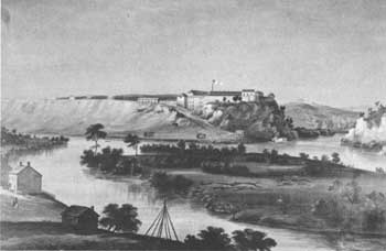
After the War of 1812 the Army, seeking to extend U.S. control over the upper Mississippi Valley, planned a fort at the confluence of the Mississippi and Minnesota Rivers, a site that had been well known to French traders, on land that Lt. Zebulon M. Pike had purchased for a pittance in 1805 from the Sioux Indians. In 1819 Lt. Col. Henry Leavenworth led a detachment up the Mississippi from Prairie du Chien, Wis., to build the fort and wintered near an Indian village at the site of Mendota, Minn. The camp, known as Camp New Hope, consisted of log cabins and a stockade. In 1820 the troops moved across the Mississippi and established Camp Goldwater just north of the mouth of the Minnesota. That same year Col. Josiah Snelling succeeded Leavenworth and began constructing a permanent fort on a 100-foot-high bluff overlooking the confluence of the Minnesota and Mississippi Rivers. The fort, completed in 1823 and named Fort St. Anthony, became Fort Snelling 2 years later. Of log and stone, it was constructed in the shape of a diamond and was surrounded by a limestone wall. More medieval in appearance than most forts, it had towers commanding the four corners.
 |
| Fort Snelling in 1844, by J. C. Wild. (Minnesota Historical Society) |
The fort, a quarter mile east of an Indian agency, guarded the region between the Great Lakes and the Missouri River. The officers cooperated with Indian Agent Lawrence Taliaferro, who served between 1819 and 1839, in preventing clashes between the Sioux and Chippewas. Later the garrison kept other Iowa, Minnesota, and Wisconsin Indians on their reservations. It also policed the Canadian border to prevent the incursions of Métis and French-Canadian buffalo hunters.
Once the frontier advanced to the Great Plains, Fort Snelling's importance declined and it became mainly a supply base. In 1857 the Army abandoned it. Reactivated in 1861 as a training center for Civil War troops, it also was instrumental in putting down the 1862 Sioux uprising in the Minnesota River Valley. The focus of conflict between Indians and soldiers subsequently shifted West, to the Dakotas, and later to Montana and Wyoming. Playing a supporting role in these operations, in 1881 the fort became headquarters of the Department of Dakota (Minnesota, the Dakotas, and Montana). In later years it was mainly a training center. In 1946 the Army departed and deeded it to the Veterans' Administration.
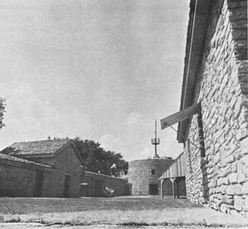
Modern bridges, highways, and urban expansion have impaired the historical scene. The Veterans' Administration, other Government Agencies, and the State have jurisdiction over various parts of the modern Fort Snelling reservation. The Minnesota Historical Society has long been active in preserving and interpreting the old fort. In 1957-58 excavations uncovered the foundations of several structures, including the powder magazine, schoolhouse, sutler's store, hospital, shops, cisterns, and a portion of the original walls. At that time, two of the original 16 buildings, constructed in the early 1820's, were still standing: a hexagonal stone tower, only slightly altered; and a round stone tower, considered the oldest building in Minnesota.
 |
| The Minnesota Historical Society is carrying out an extensive restoration-reconstruction program at Fort Snelling. The round tower, background, is one of the structures that has been restored. (Minnesota Historical Society) |
In October 1969 the State acquired from the Veterans' Administration for inclusion in Fort Snelling State Park the old fort area, a 21.25-acre tract lying to the east and north of the adjacent freeway and surrounded on three sides by the modern Fort Snelling installation. Four years before, with the permission of the Veterans' Administration, the State historical society had begun a large-scale reconstruction-restoration program. By April of 1970, it had reconstructed the guard complex, a building consisting of separate rooms that served a wide variety of functions and were separated by interior walls; pentagonal tower; 560 feet of the original wall; schoolhouse; powder magazine; sutler's store; and well house. Restorations included the old round and hexagonal towers. The society plans to furnish all the buildings in period style. When this volume went to press, it was still seeking title to a 141.39-acre tract comprising the later fort area, to the west and south of the freeway.
NHL Designation: 12/19/60
 |
 |
http://www.cr.nps.gov/history/online_books/soldier-brave/siteb12.htm
Last Updated: 19-Aug-2005